Neighbor News
Dry weather in store to finish holiday weekend; showers, thunderstorms possible Tuesday; hot weather coming for Wednesday
As this holiday weekend comes to a close tomorrow, dry and warm weather will continue to prevail. But, wet weather is possible for Tuesday.
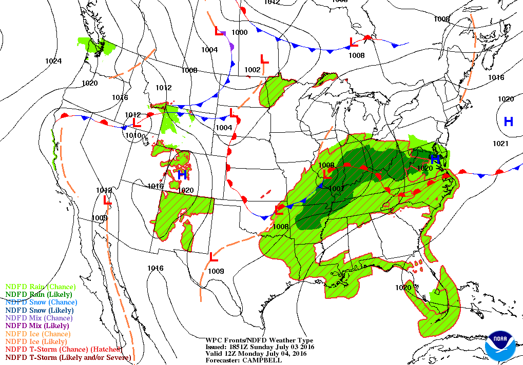

Weather Forecast Discussion for Rhode Island on July 4, 2016
We had bright sunshine during Sunday morning here in the Ocean State, although we began to see increasing clouds by the afternoon. We have mostly cloudy skies at the moment over northern Rhode Island. The cloud cover is due to low-level moisture in the atmosphere. As the sun sets, the daytime heating will end, and skies will slowly clear. We will see clear skies later tonight, with lows falling towards 60 degrees. By Monday, high pressure will move offshore. We will start the day with bright sunshine, but moisture from the south will move northward. Expect increasing clouds by the afternoon, with highs reaching the upper 80’s. With the high pressure ridge breaking down, this will allow a low pressure system over southern Illinois to creep into the Mid-Atlantic by early Tuesday morning. We may see some passing showers after midnight, moving south to north. Low temperatures Sunday night will stay in the middle 60’s.
We will return to work after the long holiday weekend on Tuesday with the risk for passing showers and thunderstorms by mid-morning. The best chance at seeing precipitation will be along the south coast, as the low’s center stays south of Long Island. We will see the precipitation activity end by 3 p.m., as the low quickly moves out to sea. Partial to bright sunshine is expected by the evening commute. With the cloud cover, high temperatures will only reach the lower 80’s. Skies will be clear by Tuesday night, with lows only falling into the middle to upper 60’s. Dewpoint temperatures will remain high, despite the clear skies. We will have sunshine on Wednesday, as we will be protected by a high pressure ridge. But, get the fans and air conditioners ready, because high temperatures are expected to reach the lower to middle 90’s. It will not be much cooler Wednesday night, as overnight lows only fall to the lower 70’s under partly cloudy skies.
Find out what's happening in East Providencefor free with the latest updates from Patch.
By Thursday, a low pressure system will begin to work its way into Northern New England. With this low, moisture will move north along a weak disturbance to our southwest. Bright sunshine in the morning will lose to overcast skies by the late morning. The low might help trigger some showers and isolated thunderstorms by mid-afternoon. High temperatures will cool into the upper 80’s. The chance for showers and thunderstorms persist into Thursday night, as the low slowly moves into the Gulf of Maine. Low temperatures will be near 70 degrees.
A weak area of high pressure ridging will be over Rhode Island on Friday, giving us a mix of clouds and sunshine. However, a warm front to our south will bring overcast skies by mid-afternoon. Daytime high temperatures will reach the middle 80’s. The frontal boundary will be just south of Block Island Friday night, giving us the slight chance for a few showers and thunderstorms entering the weekend. Overnight lows Friday night will be in the upper 60’s. With the low moving into Northern New England on Saturday, we will continue to see scattered showers and thunderstorms until the late afternoon. By then, the low’s center will be over Nova Scotia, with the cold front moving offshore. We may even see some sunshine by the early evening. Expect daytime highs to be in the middle 80’s. Skies will take a while to clear Saturday night, keeping our overnight lows pretty mild, with the mercury only falling into the upper 60’s.
Find out what's happening in East Providencefor free with the latest updates from Patch.
We will finish off the forecast period by looking at next Sunday. I have to throw the American model out, since it still keeps that low over Northern New England through the weekend. The European and United Kingdom models agree the low is already into the Canadian Maritimes. So, throwing the American model out, high pressure ridging will give us mostly sunny skies with highs in the lower to middle 80’s.
Jim Laurie is a local meteorologist who earned a B.S. in Meteorology at Lyndon State College in Lyndonville, VT. Jim has fifteen years of professional experience, with eight years in the field of marine meteorology.