Weather
With Friday being over 90 degrees, will this weekend bring Rhode Island a heat wave? Models showing great possibility
Despite the risk for strong thunderstorms this evening and late Saturday afternoon, sunny skies will bring hot temperatures to the inland.

Weather Forecast Discussion for Rhode Island on July 23, 2016
Entering this weekend, I had said in the previous discussion we could see our first “heat wave” in the Ocean state this summer. We already have one day over 90 degrees (the high at T.F. Green Friday is 92 degrees.) Thanks to the high temperatures and high dewpoints, an Air Quality Alert is in effect for all of Rhode Island until 11 p.m. this evening. So, will our temperatures go above 90 for Saturday and Sunday?
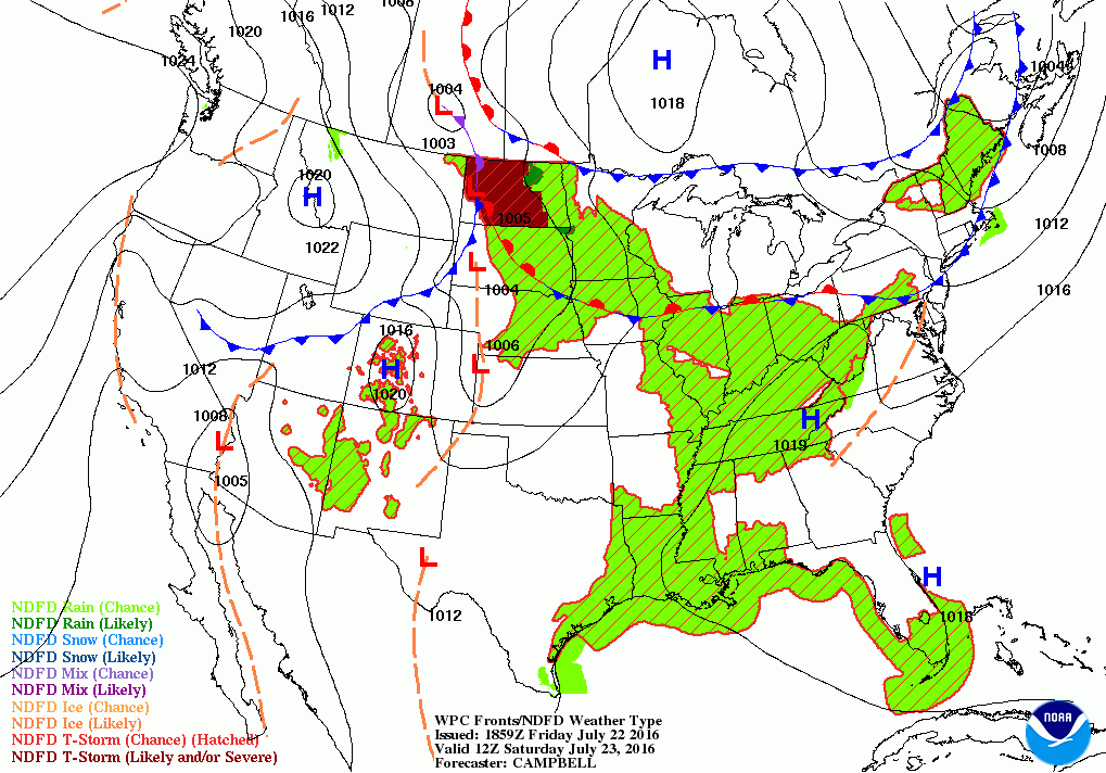
At the moment, we will be awaiting a cold front slipping into the eastern Great Lakes. This front will push through Southern New England for this evening. The front may help create scattered showers and thunderstorms from 8 p.m. until 4 a.m. Saturday morning. Some thunderstorms may be strong to severe, with strong downward wind gusts, small hail, and heavy rainfall. However, they will be more isolated than widespread. With high dewpoints, it will remain quite humid, with overnight lows in the lower 70’s. By 7 a.m., the front moves offshore, and skies will begin to clear. We will have mostly sunny skies through the early afternoon. High temperatures are forecast to be in the lower to middle 90’s.
Find out what's happening in East Providencefor free with the latest updates from Patch.
However, if you happen to be in northern or eastern Massachusetts, keep an eye to the sky. There will be some instability occurring in the atmosphere over this area, so the sun’s heating and the other factors may help create isolated strong thunderstorms, especially between the time of 2 and 5 p.m. For Rhode Island, there is a slight chance for some showers during this time, and then isolated thunderstorms from 5 p.m. to 9 p.m. A weak cold front is expected to move quickly through Southern New England, which will help enhance the instability. I would not cancel any outdoor activities for Saturday night, because the risk is very slight. We will slowly see our skies clear after midnight, as the front pushes offshore. Partly cloudy skies await by midnight, with lows in the upper 60’s.
For Sunday, high pressure coming down from central Canada will give us mostly sunny skies and lower dewpoint temperatures. The heat wave may not occur, as high temperatures Sunday are forecast to reach the upper 80’s. A light north wind may help keep our temperatures from reaching 90. However, I feel some inland areas, including Providence, will see three straight days with 90 degree temperatures. This would be an official heat wave. We will keep partly cloudy skies Sunday night, with lows falling into the upper 60’s. For Monday, an approaching cold front will bring some increasing clouds by late morning. The European and American models disagree on when the precipitation actually begins. The European is giving us showers and rain by 8 a.m. The American model feels the precipitation is behind the front, instead of ahead of it. Therefore, we would not see the first raindrops until after the evening commute. For now, I will cut it down the middle, and predict rainfall to begin by the mid-afternoon. I feel the precipitation will start ahead of the front, but will take longer for the dry atmosphere to get saturated with all of the incoming moisture. Look for the heaviest rainfall to come during the end of the evening commute. Rain will taper off during the overnight, and end before the start of the morning commute on Tuesday morning. High temperatures will reach the upper 80’s Monday, with slowly clearing skies Monday night, and lows in the lower 70’s.
Find out what's happening in East Providencefor free with the latest updates from Patch.
By Tuesday, a weak area of high pressure will bring back sunny skies, and daytime temperatures will reach the lower 90’s. We will remain in this area of dry air right into early Thursday morning. Daytime highs Wednesday will reach the upper 80’s under mostly sunny skies, with overnight lows in the upper 60’s. On Thursday, a weak cold front may bring another round of showers and moderate rain to the Ocean State by the late morning. The showers will taper off by early Friday morning, after the front passes. I am predicting highs in the middle 80’s for Thursday, with lows Thursday night in the lower 70’s.
By Friday, we will be back under the influence of a weak area of high pressure ridging. A weak upper level disturbance passing over New England may create a few passing showers in the afternoon. Otherwise, we will see more clouds than sun, with cooler high temperatures in the lower 80’s.
Jim Laurie is a local meteorologist who earned a B.S. in Meteorology at Lyndon State College in Lyndonville, VT. Jim has fifteen years of professional experience, with eight years in the field of marine meteorology.