Neighbor News
Hot, muggy weather ahead for Wednesday; possible showers, thunderstorms Thursday into Saturday; dry start to next week
After a low passes east of us, we will really feel the lazy, hazy, crazy days of summer. Temperatures hit 90 or more across the inland.
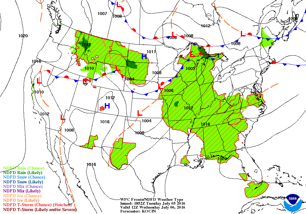

Weather Forecast Discussion for Rhode Island on July 6, 2016
After a gorgeous holiday weekend, we received some much needed rainfall last night, as a low pressure system passed through western Massachusetts. T.F. Green Airport received about 0.40 inches of rainfall by 9 a.m. Tuesday. Now, the low is moving off the Cape Cod Canal, giving the Ocean State partly to mostly sunny skies. We may still see a stray shower for the next couple of hours, before the frontal boundary passes to our east. By tonight, weak high pressure ridging will give us partly cloudy skies. However, the high dewpoints will remain, as low temperatures only fall into the upper 60’s. The ridging will remain in control for Wednesday, giving us sunny skies and hot temperatures. It will be muggy, with the mercury reaching the lower 90’s inland. A sea breeze will develop along the coast by the afternoon, keeping temperatures in the upper 70’s to lower 80’s. We will keep clear to partly cloudy skies Wednesday night, but low temperatures will continue to stay mild, staying near 70 degrees. In fact, we may see some patchy fog a few hours before sunrise Thursday, as the temperature and dewpoint come quite close together.
For Thursday, a weak area of low pressure will move over western New York. We will have sunshine in the morning, but there is the slight possibility the daytime heating and the muggy atmosphere may create some afternoon showers and thunderstorms. Any activity would not start until 2 p.m. and last into the early evening hours. With sea breezes in effect, daytime highs will range to the lower 80’s along the coast to the upper 80’s inland. If we remain sunny, the lower 90’s inland is quite possible. The low will move over New Hampshire by late Thursday night, giving us the slight chance for more showers and thunderstorms. Otherwise, we will only see mostly cloudy skies, with lows in the lower 70’s.
Find out what's happening in East Providencefor free with the latest updates from Patch.
By Friday, we will see more clouds than sunshine, as another low pressure system from the west draws closer to New England. We will see temperatures only reach the middle 80’s, as I expect increasing clouds by noon. Showers ahead of the cold front arrive by 10 p.m., with the risk for isolated thunderstorms after midnight. Lows Friday night will stay in the upper 60’s. The weekend comes a little faster, thanks to the shortened work week. However, the cold front basically stalls right over eastern Connecticut on Saturday, giving us the risk for more scattered showers and thunderstorms. For now, we will keep mostly cloudy skies, with high temperatures cooling into the lower 80’s. By Saturday night, the front finally passes Cape Cod, with partial clearing from the southwest of the low pressure system. We will see cloudy skies until 2 a.m., before skies begin to clear. With lowering dewpoints, we will see lows fall into the middle 60’s.
With high pressure sinking down from central Canada into the Ohio River Valley on Sunday, we will finally have a bright, sunny day to end the weekend. Temperatures will be more seasonable, as highs reach the lower 80’s. This high will continue to give us sunny, dry skies right into next Tuesday. Expect daytime highs Monday and next Tuesday in the lower 80’s, with lows in the lower 60’s.
Find out what's happening in East Providencefor free with the latest updates from Patch.
Jim Laurie is a local meteorologist who earned a B.S. in Meteorology at Lyndon State College in Lyndonville, VT. Jim has fifteen years of professional experience, with eight years in the field of marine meteorology.