Neighbor News
Muggy weather returns by tonight; hot, hazy, humid weather starts Wednesday, and lasts through Saturday
We had cool weather this weekend, but we will return to the three H's of summer, starting Wednesday. It continues into Saturday night.
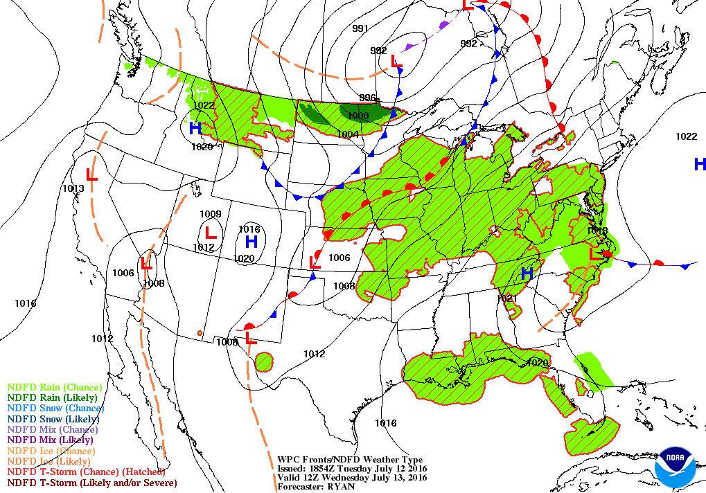

Weather Forecast Discussion for Rhode Island on July 13, 2016
After some cooler weather to start the week, temperatures climbed into the lower to middle 80’s across the Ocean State on Tuesday. High pressure offshore is helping with the warmer temperatures, as the winds come from the southwest. Also, an upper level ridge will move over New England by tonight, allowing for more moisture and warmer temperatures to move northward.
Although high pressure is well into the Atlantic, it will continue to influence our weather for tonight and Wednesday. We will keep partly cloudy skies for tonight, with lows in the middle 60’s. The humidity will begin to rise, as moisture creeps up from the Gulf of Mexico. We will begin to feel muggy weather and warmer temperatures. Expect high temperatures in the upper 80’s, with lows in the upper 60’s. With dewpoint temperatures staying in the upper 60’s to lower 70’s, it will be uncomfortable sleeping weather without a fan or air conditioning. On Thursday, a cold front extending from Canada to central Illinois will move over the state. We will see more clouds than sun, and any sunshine may cause some instability in the atmosphere. There is the slight chance for showers and isolated thunderstorms after 8 a.m. Despite limited sunshine, temperatures will still climb into the middle to upper 80’s. With the front stalled over us Thursday night, we will keep the slight risk for showers and thunderstorms through the overnight. Overnight lows will stay in the upper 60’s.
Find out what's happening in East Providencefor free with the latest updates from Patch.
The cold front will slowly push offshore by the evening commute on Friday. We will keep partly sunny skies, but there will still be the isolated chance for a shower or thunderstorm, preferably before 3 p.m. If we keep more sun than clouds, especially by the early afternoon, highs should reach the lower 90’s inland. At this time, I’ll keep it just below 90 degrees. A high pressure system moving over Pennsylvania will give us partly cloudy skies Friday night, with lows in the upper 60’s. On Saturday, a weak area of low pressure will remain south of Rhode Island, but the computer models keeps the precipitation shield south of the state. We will see partly to mostly sunny skies with highs in the upper 80’s. By Saturday night, we may see a passing shower across the south coast. Otherwise, expect mostly cloudy skies with dewpoints lowering. The upper level ridge will break down, and give way to a weak upper level trough. Low temperatures remain quite warm, with the mercury only falling into the upper 60’s.
Going into Sunday, a weak ridge of high pressure will try to protect Southern New England from any precipitation. We will keep partly sunny skies in the forecast, as there is still some moisture at the lower level of the atmosphere to create some stratus clouds. With lowering dewpoints, high temperatures will only reach the lower 80’s. Weak high pressure over the Mid-Atlantic will keep us dry, with partly to mostly cloudy skies. Skies will slowly clear Sunday night, as the high slowly dries out the atmosphere. We will see partly cloudy skies by sunrise, with lows in the middle 60’s.
Find out what's happening in East Providencefor free with the latest updates from Patch.
On Monday, we will start off with some sunshine, before a weak cold front makes its way into New England by the evening. Expect sunny skies through the morning, with partly sunny to mostly cloudy skies through the afternoon. Showers may arrive by Monday night. Expect high temperatures in the lower 80’s, with lows in the middle 60’s Monday night. The models are unclear whether the precipitation ends by the morning hours, or if we remain dry Tuesday, with the threat of showers by the evening. With the United Kingdom model agreeing more with the European, I will keep showers entering Monday night, and continuing into Tuesday morning. Another low moving into the Great Lakes may bring some late showers into early Wednesday morning.
First Pitch Forecast (for McCoy Stadium, home of the Pawtucket Red Sox)
July 14th vs. Charlotte (7:05 p.m.): Mostly cloudy, slight chance of a shower/thunderstorm, 80.
Jim Laurie is a local meteorologist who earned a B.S. in Meteorology at Lyndon State College in Lyndonville, VT. Jim has fifteen years of professional experience, with eight years in the field of marine meteorology.