Neighbor News
Thunderstorms moving through Rhode Island right now; activity will be limited Friday, but risk increases Friday night
A slightly moving frontal boundary and weak lows will result in the Ocean State seeing the risk for showers/thunderstorms for 24-36 hours.
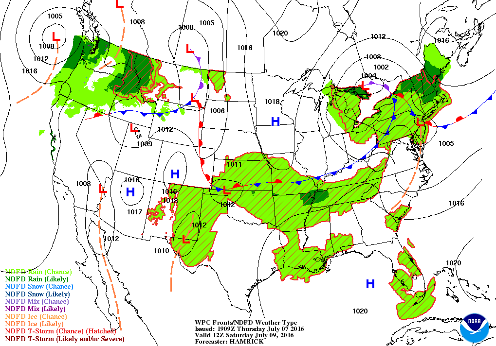

Weather Forecast Discussion for Rhode Island on July 8, 2016
Before we begin, I just want to update everyone that the Ocean State is not under a Severe Thunderstorm Warning as of 3:50 p.m. However, northwest Providence County is now under a Flood Warning, until 6:45 p.m., due to thunderstorms developing over the area within the last 30 minutes. Due to the possible heavy rainfall under these conditions, you may see street flooding or flooded roads. Please take precaution during this time.
The latest radar images are showing that a frontal boundary over eastern Massachusetts is helping to create showers and thunderstorms, with widespread precipitation taking over much of the state. Expect this activity to continue into the evening, with some thunderstorms containing strong winds, small hail, and heavy rain. The activity will begin to weaken after 11 p.m., due to the front moving slightly southward, as well as losing the daytime heating from the sun. We will see patchy fog across the state, due to the high dewpoint temperatures. Expect low temperatures tonight to only fall to 70 degrees. As we move into Friday, drier air in the middle levels of the atmosphere will help limit any precipitation during the daytime hours. A new low pressure system coming from the Mid-Atlantic will be south of Rhode Island by the afternoon. We will see limited sunshine at times, with the slight risk for a shower or thunderstorm. With northeast winds, our high temperatures will struggle to reach 80 degrees. The chance for more showers and thunderstorms increase into Friday night, as waves of low pressure to our south helps destabilize our atmosphere. The best chance for rainfall will be after midnight. Low temperatures are only expected to fall into the upper 60’s.
Find out what's happening in East Providencefor free with the latest updates from Patch.
As we begin the weekend, the waves of low pressure remain south of us, but the main low over northwest New York will enhance our risk for more scattered showers and thunderstorms for Saturday. With the continued northeast winds, high temperatures will only reach the middle 70’s. As the low slowly moves over Vermont Saturday night, the precipitation shield moves off to the north and east. We will keep mostly cloudy skies, with the slight risk for a passing shower or thunderstorm. Expect lows to fall into the middle 60’s. By Sunday, we will begin to see improving weather, as the low weakens and moves further east. It will be cloudy in the morning, with some sunshine throughout the afternoon. But, it will remain cool, with highs in the middle 70’s. Drier air finally moves over New England by Sunday night, allowing for partly cloudy skies before sunrise. Low temperatures are expected to fall into the lower 60’s.
High pressure finally moves over the eastern U.S. by Monday, bringing back mostly sunny skies. Despite the sunshine, cooler air in the upper levels of the atmosphere will limit our high temperatures to the lower 80’s. Partly cloudy skies are forecast for Monday night, with lows in the lower 60’s. Looking ahead from Tuesday into Thursday, a weak high pressure center well south of Long Island will continue to influence our weather. We will see mostly sunny skies through the rest of the forecast period. With winds slowly turning to the southwest, high temperatures will slowly increase, with highs in the lower 80’s Tuesday and in the middle 80’s next Wednesday. Some cooler air arrives Thursday, lowering highs to the lower 80’s. Overnight lows will increase from the lower 60’s Tuesday to the middle 60’s Wednesday and next Thursday.
Find out what's happening in East Providencefor free with the latest updates from Patch.
Jim Laurie is a local meteorologist who earned a B.S. in Meteorology at Lyndon State College in Lyndonville, VT. Jim has fifteen years of professional experience, with eight years in the field of marine meteorology.