


After discovering that maps are rarely accurate, I went looking for other areas that are poorly represented. On Google Maps I stumbled upon a thin strip of green cutting horizontally across the state, from the Connecticut border to the outskirts of Warwick. It's so small that unless you zoom in really far, you wouldn't know it was there.
The Rails to Trails Conservancy has converted more than 19,000 miles of railway tracks to walking, hiking and biking trails since they were founded in 1986. The first section of the Coventry Greenway was opened in 1998 and holds the distinction of being both the 1,000th U.S. rail-to-trail conversion and the 10,000th mile of trail. That mile of trail lays in Greene, R.I., a place no one really needs to go to and hasn't since the railroad closed in 1968.
Narragansett to… Greene
Find out what's happening in Narragansett-South Kingstownfor free with the latest updates from Patch.
Total Trip Mileage: Approximately 60 miles roundtrip.
Trip Time: An hour each way - yes I am aware that is longer than 45 minutes but we are pushing boundaries here!
Find out what's happening in Narragansett-South Kingstownfor free with the latest updates from Patch.
Pack: A little slice of civilization, because there isn't any here.
As much as I love avoiding the highway, this time I headed north on Route 1, merged onto Route 4 and took Exit 5. I had mapped out several alternative routes but the adage "you can't get there from here" definitely applies when driving in a northwesterly direction in Rhode Island. I turned left onto Route 102 and said goodbye to civilization. It would be a long time before I saw the marvelous vestige of capitalism that is Walmart again.
Clouds refused to give up the sun and Mother Nature was pushing out Autumn so Winter could rush in. Leafless trees were dark against the gray skies and I remembered how hard it had been to get out of my warm bed. And then I wondered why I had even bothered at all. I had lingered under the blankets but my sense of adventure had gotten the better of me while imagining what I might discover.
If you pick a destination you create an expectation. It is occasionally surpassed but rarely fulfilled. As I drove along I thought about what I had seen on the map, but there are so few key features in Greene that I was at a loss to develop much of a mental picture. That should have been a clue.
It would be easy enough to follow Route 102 straight up to Greene, but that's too simple and not my style. No, I prefer to take unnecessary "shortcuts" that don't deliver efficiency in time or distance, but take you to a place you would never have a reason to visit otherwise.
A tornado of leaves veered wildly from the side of the road out toward traffic before dying in a quick implosion. I took a right onto Widow Sweets Road, named after the denizen of a nearby cemetery. The narrow road is barely two lanes wide, which always causes me to wonder what I might do if a car were to approach from the other direction. For every twist and turn, mailbox and tree close to the road's edge, I imagine how I would react to an oncoming car. It wasn't until later in my trip that I entered into a game of chicken with a UPS truck. (I backed down and slammed on the brakes, clearly cementing my image as a skilled aggressive driver.)
Every map I have access to plainly shows Widow Sweets Road running straight along and intersecting New London Turnpike directly across from Congdon Mill Road. Even the broadest definition of "road" would not include the last half-mile of Widow Sweets Road. The pavement gives way to a dirt road with several houses along it, but it ends a quarter mile short at a couple boulders on the edge of the woods.
I backtracked to the pavement and took the left onto Falcon Ridge Drive, which made my "shortcut" a waste of time. The houses along the road were a diverse collection of the kind of people who live in the middle of nowhere. Everyone from those with the luxury to live "away from it all," to the strange hermits who need extra space for the voices in their heads. Rusted out minivans seem to be a popular yard decoration in these parts.
Reaching the end I turned right and my car rattled along the washboard dirt surface of New London Turnpike before easing onto a paved portion. On either side of the road pickup trucks were pulled off into the woods – hunters. Considering that it was the middle of the day in the middle of the week, I was surprised by there being more than a dozen trucks along the road.
Congdon Mill Road becomes Robin Hollow Road after it crosses Nooseneck Hill Road. Mark's Big River Inn sits on the corner and boasts karaoke on Friday nights. Judging by the demographics of the area it must be an interesting show. The road plunges down a steep hill and passes below the dual underpasses of Interstate 95. Leftover snow from Sunday night's freak precipitation remained in the shadow of the highway.
Route 102 is in no way remarkable, but it's a necessary evil unless you want to drive down a few more dirt roads that may or may not actually exist. I cruised north at a good clip to get this leg of the journey out of the way, before turning left onto Perry Hill Road at the flashing yellow lights on Route 102.
It was along this road that I encountered the UPS truck, and the thick forest and adjacent rock walls offered no room to dive off to the side. Off to the right side of the road were two cobblestone posts, with the words "Mays" and "Hidden Hollow Farm" engraved into stone blocks. They marked the entrance to a farm that no longer exists and hasn't for a while - there is no trace of the driveway or buildings.
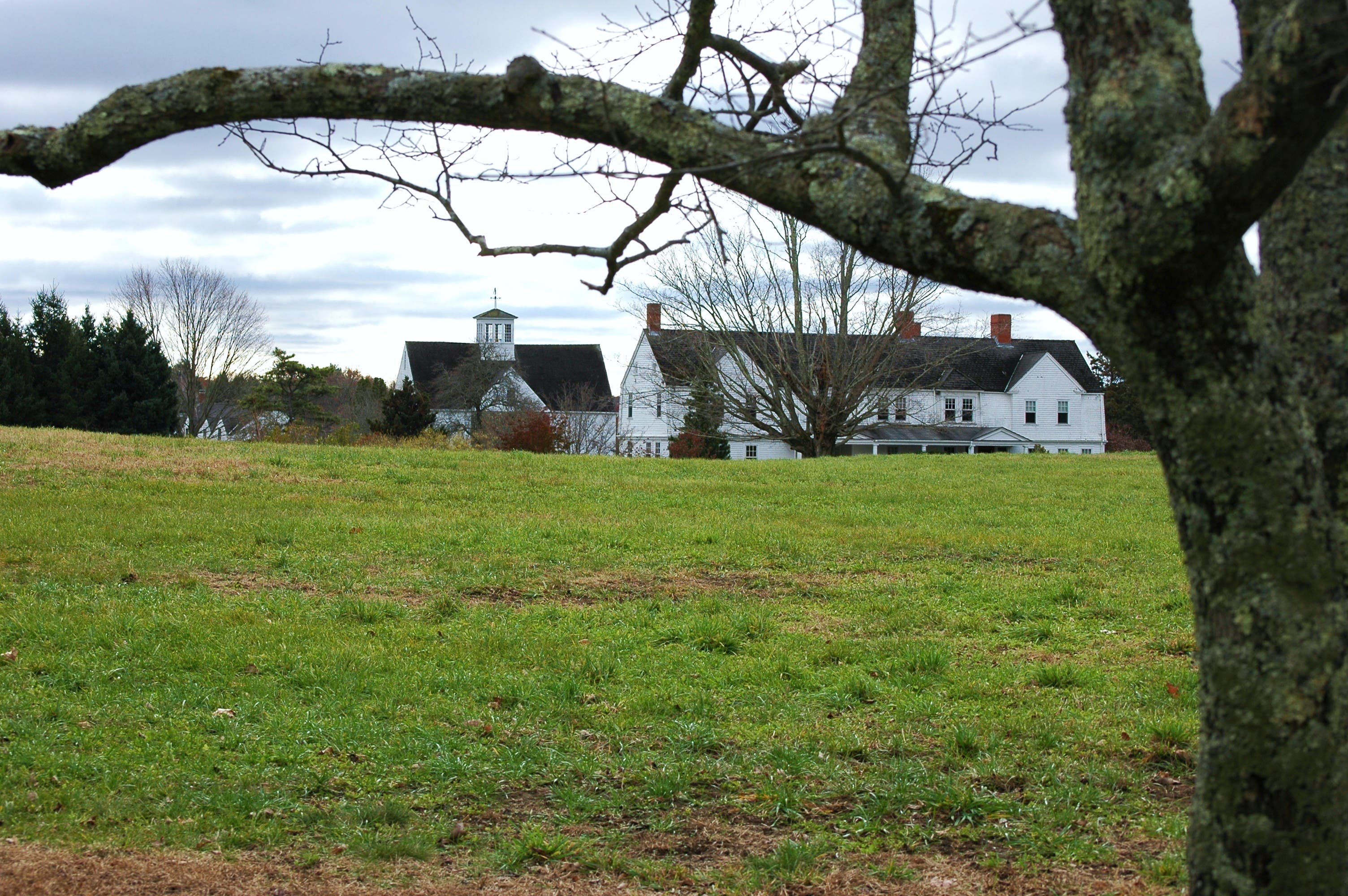
Perry Hill Road ended abruptly in one of the nicer areas I had driven through so far, and I turned right. A beautiful house and large barn topped with a weathervane sit in an open field. Carefully crafted stone walls run along the road for a hundred feet and tall, evenly spaced trees branch out over the road. If they weren't completely devoid of leaves I bet they would look gorgeous. The field is a breath of fresh air before I dove back into pine groves.
Taking a right onto Hopkins Hill Road I began to wonder about my destination and how I would know when I was actually there. I slowed down to a crawl so I wouldn't miss the 12-foot wide path I had journeyed far and wide to get to. Passing the Green Public Library on my left, I found the only landmark to identify the Coventry Greenway at the corner of Benefit Street, a railroad truck on three feet of track and a plaque commemorating the railroad that ran through Greene from 1854 until 1968.
Not to be confused with the wide, paved bike path that begins in Coventry Center, this stretch of the Greenway is nothing more than a tunnel through the brush. I parked in the dirt patch on the corner and started to walk down the path. I left the only set of footprints. The path was textured with the tracks of ATVs, and several branches had dipped low enough that I had to duck around them. The ground undulated like the scalloped edge of a birthday cake and added a bounce to my step.
I felt very unsure about myself as I walked and an eerie feeling crept down my spine. Benefit Street is just 15 feet off to the left, and the ground slopes down to the path on either side. I walked along until the trail met up with the end of the street and I peered down through the tunnel of brush. Every so often I'm tempted to journey back there and finish what I had wanted to start, but next time I would bring a friend, because at that moment it felt like it could be my last walk in the woods.
I turned around and strode briskly back to my car. I continued north on Hopkins Hollow Road to where it curves around and becomes Route 117. Right as you turn south onto Route 102, a bridge carries you up and over the woods and I looked down on either side and I could just make out the trail. If I could just ditch that strange feeling I could walk all the way to Warwick.