Weather
Coastal Storm Could Bring Half A Foot Of Snow To Parts Of RI
Rain will turn into a wet, heavy snow, with some parts of the state seeing half a foot of accumulation.

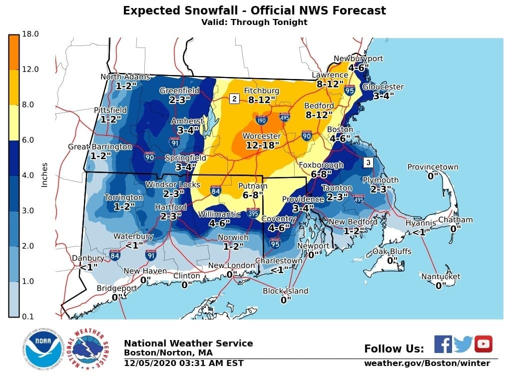
A nasty Nor'easter has taken aim at Southern New England Saturday, with snow totals again upped across the region. What started as a rainy day will turn into snow, leading to messy conditions across the state.
The National Weather Service has continued to raise the expected snow totals in the days leading up to the storm, with Saturday morning's updated forecast showing parts of the state could see as much as 6 inches of accumulation. A winter storm warning is in effect from 1 p.m. Saturday until 7 a.m. Sunday, and a wind advisory is in place from 1 p.m. until midnight.
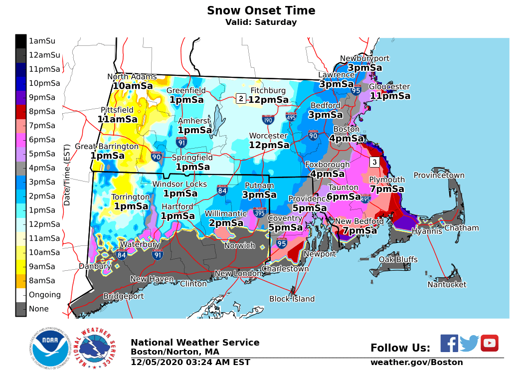
Most of the state should see the first flakes fall mid-evening, though the southern coast likely won't see any snow until the overnight hours. The central part of the state is expected to be hit the hardest, with four to six inches possible in Coventry.
Find out what's happening in Newportfor free with the latest updates from Patch.
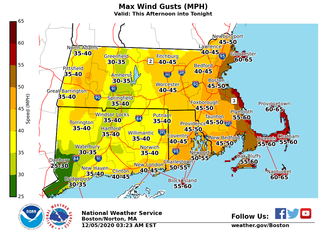
The combination of the wet, heavy snow with high winds could lead to downed trees, power lines and power outages. While the East Bay and southern coast aren't expected to see much in the way of accumulation, they'll be hit hardest by the winds, which could top out at 60mph on Block Island. Keep electronic devices charged in case of a power outage.
Here's a look at the latest forecast from the National Weather Service.
Find out what's happening in Newportfor free with the latest updates from Patch.
Saturday
Rain before 3 p.m., then rain and snow. The rain and snow could be heavy at times. Temperature falling to around 35 by 3 p.m. Breezy, with a north wind 14 to 19 mph increasing to 20 to 25 mph in the afternoon. Winds could gust as high as 47 mph. Chance of precipitation is 100 percent. Total daytime snow accumulation of 1 to 2 inches possible.
Saturday Night
Snow, mainly before 9 p.m. The snow could be heavy at times. Low around 28. Blustery, with a northwest wind 16 to 23 mph, with gusts as high as 44 mph. Chance of precipitation is 80 percent. New snow accumulation of 1 to 2 inches possible.
Sunday
Sunny, with a high near 39. Northwest wind 11 to 15 mph, with gusts as high as 29 mph.
Sunday Night
Mostly clear, with a low around 25. West wind 6 to 9 mph.
Monday
Mostly sunny, with a high near 38. West wind 6 to 8 mph.
Monday Night
Partly cloudy, with a low around 26. North wind 5 to 9 mph.
Tuesday
Mostly sunny, with a high near 37. North wind 9 to 11 mph.
Tuesday Night
Mostly clear, with a low around 25. Northwest wind around 7 mph.
Get more local news delivered straight to your inbox. Sign up for free Patch newsletters and alerts.