Weather
RI Weather: Up To 3 Inches Of Snow On The Way
Several cities and towns already have parking bans in place.


Snow is once again in the forecast for Rhode Island, with some areas of the state expected to see up to three inches of accumulation. Several cities and towns have already announced parking bans for Tuesday night and Wednesday.
The snow is expected to arrive mainly after 4 p.m. Tuesday and continue until around noon on Wednesday. Snow showers are possible throughout the day Wednesday, but expect the main accumulation from Tuesday night to Wednesday morning.
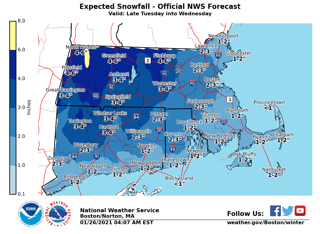
Most of the state will see one to two inches of snow accumulation, with up to three inches possible in Coventry and the central part of the state. Coastal areas and Block Island will see the lowest snow totals in the state.
Find out what's happening in Newportfor free with the latest updates from Patch.
- Cranston: 5 p.m. Tuesday to noon Wednesday
- Smithfield: noon Tuesday to noon Wednesday
Here's a look at the latest Rhode Island forecast from the National Weather Service.
Tuesday
Snow showers likely, mainly after 4 p.m. Mostly cloudy, with a high near 37. East wind around 7 mph. Chance of precipitation is 60 percent. Total daytime snow accumulation of less than a half inch possible.
Find out what's happening in Newportfor free with the latest updates from Patch.
Tuesday Night
Snow showers. Low around 29. Northeast wind around 8 mph. Chance of precipitation is 80 percent. New snow accumulation of 1 to 3 inches possible.
Wednesday
Snow showers likely before noon, then a chance of rain showers. Cloudy, with a high near 39. North wind around 7 mph. Chance of precipitation is 60 percent. New snow accumulation of less than a half inch possible.
Wednesday Night
A chance of snow showers, mainly before 5 a.m. Cloudy, with a low around 29. North wind 3 to 7 mph. Chance of precipitation is 30 percent. New snow accumulation of less than one inch possible.
Thursday
A slight chance of snow showers before 9 a.m. Mostly cloudy, with a high near 36. North wind 9 to 13 mph. Chance of precipitation is 20 percent.
Thursday Night
Mostly clear, with a low around 11. Northwest wind around 11 mph, with gusts as high as 24 mph.
Friday
Sunny, with a high near 22. Northwest wind 13 to 16 mph, with gusts as high as 31 mph.
Friday Night
Mostly clear, with a low around 7. Northwest wind 10 to 14 mph.
Saturday
Sunny, with a high near 25. Northwest wind around 11 mph.
Saturday Night
Mostly clear, with a low around 12. Northwest wind around 7 mph.
Sunday
Partly sunny, with a high near 32. North wind around 6 mph becoming northeast in the afternoon.
Sunday Night
A chance of snow showers. Mostly cloudy, with a low around 22. Northeast wind 6 to 8 mph. Chance of precipitation is 30 percent.
Get more local news delivered straight to your inbox. Sign up for free Patch newsletters and alerts.


