Weather
RI's Long-Term Spring Forecast Should Warm You Up
April and May are expected to be warmer than usual, and temperatures should start normalizing once we approach summer.


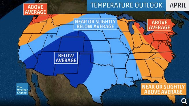
It's still kind of chilly out there, but a long-term spring forecast has things heating up soon. The Weather Channel's spring outlook has above-average temperatures for the next two months as the region drags itself out of a winter that saw some exceptional cold. Forecasters at the Weather Channel said their climate and statistical models mostly agree that the next few months will be warmer than usual.
The big thaw is expected to begin in April, with higher-than-normal temperatures forecast. The warm-up should continue in May, but we may see a cooling off period due to the above-average soil moisture thanks to the late-season snow. If El Niño conditions persist, that could also level off temperatures a bit.
Temperatures are expected to get back to normal in June, which isn't so bad since "normal" means pretty warm heading into the summer.
Find out what's happening in Newportfor free with the latest updates from Patch.
The Weather Channel's early look at summer also calls for warmer-than-normal temperatures.
Find out what's happening in Newportfor free with the latest updates from Patch.


What's more concrete at this time is that spring will start wet. A potentially heavy rainstorm is expected to come Thursday into Friday. Patch will update as the forecast solidifies.
Providence-area weather forecast via NWS Boston
Tuesday night - Mostly clear, with a low around 25. Northwest wind around 5 mph becoming calm in the evening.
Wednesday - Sunny, with a high near 52. Calm wind becoming southwest 5 to 8 mph in the afternoon.
Wednesday night - Increasing clouds, with a low around 34. South wind 5 to 7 mph.
Thursday - A slight chance of rain and snow before 8am, then rain likely. Mostly cloudy, with a high near 47. South wind 6 to 10 mph, with gusts as high as 25 mph. Chance of precipitation is 60%. Little or no snow accumulation expected.
Thursday night - Rain likely, mainly before 2am. Mostly cloudy, with a low around 38. Southeast wind around 6 mph becoming northeast after midnight. Chance of precipitation is 70%.
Friday - A chance of rain before 2pm, then a chance of showers after 2pm. Partly sunny, with a high near 48. West wind 9 to 13 mph. Chance of precipitation is 40%.
Friday night - A chance of showers before 8pm. Mostly cloudy, with a low around 27. Northwest wind 13 to 15 mph, with gusts as high as 26 mph. Chance of precipitation is 30%.
Saturday - Mostly sunny, with a high near 41. Northwest wind around 17 mph, with gusts as high as 29 mph.
Saturday night - Mostly clear, with a low around 29. Northwest wind 9 to 14 mph.
Sunday - Sunny, with a high near 52. West wind 9 to 13 mph.
Sunday night - Mostly clear, with a low around 37. West wind 7 to 9 mph.
Monday - Mostly sunny, with a high near 53. West wind 6 to 9 mph.
Get more local news delivered straight to your inbox. Sign up for free Patch newsletters and alerts.


