Seasonal & Holidays
Tropical Storm Watch From Watch Hill To Plymouth: National Weather Service
The National Weather Service has issued a Tropical Storm watch that includes Newport, Washington County, Block Island.


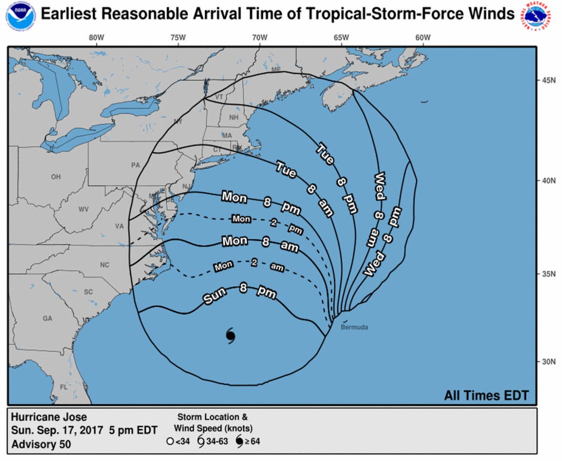
The National Weather Service in Taunton at 6:02 p.m. Sunday issued a new advisory. The locations affected are from Watch Hill to Plymouth, Mass. Other parts of the state are not under the watch currently but could see impacts, such as rain. Jose's track is still unclear. Here is the latest information.
Hurricane Jose will likely weaken to a tropical storm before nearing southern New England but will still bring a variety of significant hazards.
Tropical Storm Force winds may impact coastal Rhode Island including
Block Island, and coastal portions of southeast Massachusetts
including Cape Cod, Martha`s Vineyard, and Nantucket by sometime
Tuesday afternoon and result in scattered power outages.
Other hazards include potential severe beach erosion, minor to
moderate coastal flooding, and heavy rain. We are especially concerned
with the potential severe beach erosion along ocean coastlines of
Rhode Island and southeast Massachusetts. Some protective dunes may be
overtopped or severely eroded by this storm.
Across the coastal waters south and southeast of New England, seas
will likely build to over 20 feet and result in an extremely dangerous
marine environment. Mariners are advised to be in port by Monday
night.
PRECAUTIONARY/PREPAREDNESS ACTIONS ----------------------------------
* OTHER PREPAREDNESS INFORMATION:
If you live in a place that is particularly vulnerable to high wind
such as a mobile home or on a boat, plan to move to safe shelter.
If you are a mariner, make sure that your boat is moored very securely
or remove it from the water while there is still time.
Always heed the advice of local officials and comply with any orders
that are issued. Do not needlessly jeopardize your life or the lives
of others.
Closely monitor NOAA Weather Radio, NWS web pages, NWS social media
messages, or other local news outlets for official storm information.
* Additional sources of information:
- For information on appropriate preparations, see READY.GOV
- For information on creating an emergency plan, see GETAGAMEPLAN.ORG
- For additional disaster preparedness information, see REDCROSS.ORG
* WIND
- LATEST LOCAL FORECAST: Equivalent Tropical Storm force wind
- Peak Wind Forecast: 30-40 mph with gusts to 45 mph
- Window for Tropical Storm force winds: Tuesday afternoon
until Wednesday evening
Find out what's happening in Newportfor free with the latest updates from Patch.
- CURRENT THREAT TO LIFE AND PROPERTY: Moderate
- Emergency planning should include a reasonable threat for
strong tropical storm force wind of 58 to 73 mph.
- To be safe, earnestly prepare for the potential of
significant wind impacts. Efforts should now be underway to
secure all properties.
- Dangerous wind is possible. Failure to adequately shelter
may result in injury.
- POTENTIAL IMPACTS: Significant
- Some damage to roofing and siding materials, along with
damage to porches, awnings, carports, and sheds. A few
buildings experiencing window, door, and garage door
failures. Mobile homes damaged, especially if unanchored.
Unsecured lightweight objects become dangerous projectiles.
- Several large trees snapped or uprooted, but with greater
numbers in places where trees are shallow rooted. Several
fences and roadway signs blown over.
- Some roads impassable from large debris, and more within
urban or heavily wooded places. A few bridges, causeways,
and access routes impassable.
- Scattered power and communications outages, but more
prevalent in areas with above ground lines.
Find out what's happening in Newportfor free with the latest updates from Patch.
* STORM SURGE
- Latest Local Forecast: Up to 2 feet.
- Threat to Life and Property: Minor to Moderate coastal flooding with
areas of 1 to 3 feet of inundation.
- Potential Impacts: Some coastal roads and residential basements
may be flooded. Some protective dunes may be severely eroded.
* FLOODING RAIN
- LATEST LOCAL FORECAST:
- Peak Rainfall Amounts: 1-3 inches, with locally higher
amounts
- CURRENT THREAT TO LIFE AND PROPERTY: Elevated
- Emergency planning should include a reasonable threat for
minor flooding where peak rainfall totals are near amounts
conducive for localized flash flooding and rapid inundation.
- To be safe, prepare for the potential of limited flooding
rain impacts.
- Localized flooding is possible. If flood related watches
and warnings are issued, heed recommended actions.
- POTENTIAL IMPACTS: Limited
- Localized rainfall flooding may prompt a few evacuations.
- Rivers and tributaries may quickly rise with swifter
currents. Small streams, creeks, canals, arroyos, and
ditches may become swollen and overflow in spots.
- Flood waters can enter a few structures, especially in
usually vulnerable spots. A few places where rapid ponding
of water occurs at underpasses, low-lying spots, and poor
drainage areas. Several storm drains and retention ponds
become near-full and begin to overflow. Some brief road and
bridge closures.
* TORNADO
- LATEST LOCAL FORECAST:
- Situation is unfavorable for tornadoes
- CURRENT THREAT TO LIFE AND PROPERTY: None
- Emergency planning need not include a threat for tornadoes.
Showers and thunderstorms with strong gusty winds may still
occur.
- Little to no preparations needed to guard against tropical
tornadoes.
- Ensure readiness for the next tropical tornado event.
- POTENTIAL IMPACTS: Little to None
- Little to no potential impacts from tornadoes.
* FOR MORE INFORMATION:
- http://weather.gov/box
Get more local news delivered straight to your inbox. Sign up for free Patch newsletters and alerts.