Weather
Tropical Storm Cindy: Middle Tennessee Preps For Heavy Rains
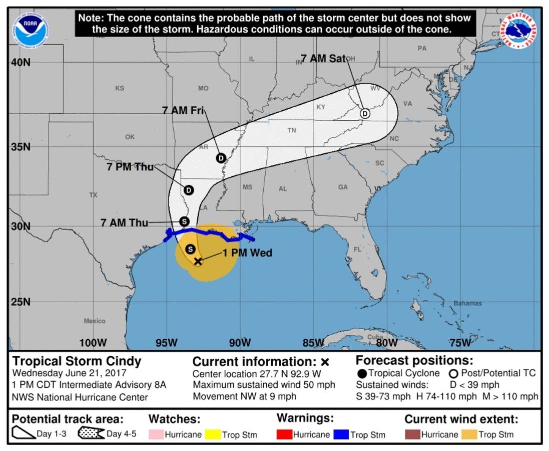
The latest track of Tropical Storm Cindy shows the storm chugging straight across Tennessee later this week.

NASHVILLE, TN — The latest track for Tropical Storm Cindy brings the storm through the heart of Tennessee starting Thursday and continuing through the weekend.
Cindy will make landfall late Wednesday along the Gulf Coast of Louisiana and Texas, where the National Hurricane Center issued tropical storm warnings from Houston to the mouth of the Mississippi. Heavy rains are already falling, particularly along the sodden eastern half of the storm. Maximum sustained winds are 60 mph with tropical-storm force winds extending 205 miles from the center of the storm. (For more updates on this story and free news alerts for your neighborhood, sign up for your local Middle Tennessee Patch morning newsletter.)
But it isn't the winds that have forecasters and emergency management teams concerned. It's torrential rains, already dumping up to five inches along the coast before the storm even makes landfall and much of that moisture is headed to Middle Tennessee, according to the National Weather Service office in Old Hickory.
Find out what's happening in Nashvillefor free with the latest updates from Patch.
"The remnants of Tropical Storm Cindy are expected to produce significant rainfall amounts across Middle Tennessee beginning Thursday and lasting through Saturday. Total rainfall amounts for this period are expected to range from 2 to 4 inches. This could produced localized flash flooding," the NWS said. "In addition to the flooding potential, there is the possibility of strong to severe storms developing Thursday through Friday night with the approach of the tropical storm remnants. The primary threat is strong to damaging straight line winds. However, tropical systems are known to also produce weak, short-lived tornadoes."
All of the Midstate is under a marginal risk of severe storms Thursday, with the northern half of the region — roughly an east-west line passing through Franklin and Murfreesboro — again under marginal risk Friday, with the southern half under "slight" risk.
Find out what's happening in Nashvillefor free with the latest updates from Patch.
The heaviest rains are expected in a swath of Middle Tennessee roughly north of Interstate 40 and south of a Dover-to-Red Boiling Springs line, where four inches of rain are possible. South of I-40 and north of a Columbia-to-Murfreesboro-to-Crossville line, three to four inches are expected. South of that line to the Alabama border, two to three inches are expected.
The Tennessee Valley Authority is drawing down lake and reservoir levels across its area of control. Patch called and emailed the Nashville District of the United States Army Corps of Engineers, which controls most of Middle Tennessee's lakes to determine if they'd follow suit, but has yet to receive a response.
Image via National Weather Service/National Hurricane Center
Get more local news delivered straight to your inbox. Sign up for free Patch newsletters and alerts.