Weather
Travis, Williamson Counties Under Severe Thunderstorm Watch
Powerful storms are expected to descend upon the Austin region for the second time this week since Sunday when flood warnings were issued.


AUSTIN, TX — The National Weather Service has placed Travis and Williamson counties under a severe thunderstorm watch until 9 p.m. on Wednesday.
According to the National Weather Service, a 50 percent chance of showers and thunderstorms is being forecast after 4 p.m., and some of the storms could be severe. Until then, it's expected to be mostly sunny with a high near 88 degrees, with a calm wind blowing from the south at between five and ten miles per hour. New rainfall amounts between a quarter and half an inch are possible, according to forecasters.
By nightfall, showers and thunderstorms likely, mainly before 10 p.m., according to the forecast. Once the rain descends, motorists are urged to visit ATXfloods.com to see low-water crossings that are closed off and should be avoided.
Find out what's happening in Austinfor free with the latest updates from Patch.
#ATXWx Alert: The @NWSSanAntonio has issued a Severe Thunderstorm Watch until 9pm CDT this evening for 6 counties in South Central Texas including: Travis - Williamson - Bastrop - Burnet - Fayette - Lee Remain #WeatherAware, #StaySafe, & monitor local forecasts for updates. pic.twitter.com/3xlpe1G0QQ
— ATCEMS (@ATCEMS) May 27, 2020
The severe thunderstorm watch covers a wide swath other than Travis and Williamson counties. Other counties that are under the weather advisory are: Austin; Bastrop; Bell; Bosque; Brazoria; Brazos; Burleson; Burnet; Chambers; Colorado; Comanche; Coryell; Erath; Falls; Fayette; Fort Bend; Freestone; Galveston; Grimes; Hamilton; Hardin; Harris; Jefferson; Lampasas; Lee; Leon; Libety; Limestone; Madison; Matagorda; McLennan; Milam; Mills; Montgomery; Orange; Roberston; San Jacinto; Travis; Walker; Waller; Washington; and Wharton.
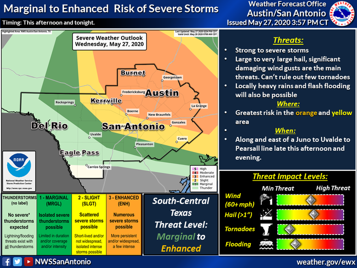
National Weather Service graphic.
Find out what's happening in Austinfor free with the latest updates from Patch.
Weather officials offer ways to prepare and stay safe:
- Unplug electronic equipment. Power surges from lightning can damage computers, monitors and TVs, and cause sparks that might start a fire.
- If it’s safe, bring in outdoor furniture and other items that could blow away. These may become a hazard.
- Stay inside a building or car that’s not a convertible.
- Rubber tires won’t protect you from lightning so avoid touching metal inside the car.
- Close windows, shutters, blinds, shades, and curtains. This will help keep out wind, rain, and broken glass.
- Make sure outside doors are securely closed. This will help keep out wind and rain.
From earlier:
AUSTIN, TX — Potentially severe weather is returning to Austin on Wednesday as powerful storms head into Central Texas for a second time this week.
According to the National Weather Service, a 50 percent chance of showers and thunderstorms is being forecast after 4 p.m., and some of the storms could be severe. Until then, it's expected to be mostly sunny with a high near 88 degrees, with a calm wind blowing from the south at between five and ten miles per hour. New rainfall amounts between a quarter and half an inch are possible, according to forecasters.
By nightfall, showers and thunderstorms likely, mainly before 10 p.m., according to the forecast. Forecasters noted some of the storms could be severe. Nighttime conditions will be mostly cloudy, with a low around 65. An east/northeast wind is expected to linger at speeds between five to ten miles per hour. The chance of precipitation is 60 percent. New rainfall amounts between a tenth and quarter of an inch are being predicted, except higher amounts possible in thunderstorms.
If severe storms materialize, it will be the second time since Sunday that severe weather has hit the area. The region was pelted with strong thunderstorms on Sunday, yielding flash flood warnings throughout the area.
As always during such rain, motorists are urged to visit ATXfloods.com to see low-water crossings that are closed off and should be avoided.
Conditions will improve exponentially after the rain. By Thursday, forecasters said the chance of showers and thunderstorms will be reduced to 20 percent. It will be partly sunny, with a high temperature near 86 degrees. Wind will be negligible at around five miles per hour, blowing in from the west/northwest. Thursday night is expected to be partly cloudy, with a low around 66. East northeast wind will be around 5 miles per hour, becoming calm in the evening.
Friday will bring mostly sunny skies with a high temperature near 87 degrees. A north wind of between five and ten miles per hour will blow. And Friday night is expected to be mostly clear, with a low around 66 degrees. Northeast wind of around five miles per hour will become calm after midnight.
Get more local news delivered straight to your inbox. Sign up for free Patch newsletters and alerts.


