Weather
Austin, Surrounding Area Under 'Severe Thunderstorm Watch'
Line of thunderstorms will descend on region Tuesday evening, with the possibility of hail, strong winds and remote chance of tornadoes.


AUSTIN, TX — A severe thunderstorm watch has been issued for Central Texas to alert residents of incoming downpours Tuesday evening that could be accompanied by hail, strong winds and a chance for tornadoes, according to the National Weather Service.
The line of thunderstorms is expected to move into the Austin region between 7:15 p.m. and 7:30 p.m. this evening. Rain — albeit light precipitation — is already being reported along U.S. 183 and MoPac Expressway (Loop 1). The former corridor from U.S. 290 to SH 71 is one of the city's key arteries, the four-lane divided highway serving as the primary route to and from the Austin-Bergstrom International Airport.
"We have increasing confidence in the potential for severe thunderstorms to develop this afternoon and into the evening hours," National Weather Service officials said in the advisory. "A cold front will move through and could produce severe storms with the potential for very large hail as well as damaging straight line winds. This threat will continue through midnight tonight."
Find out what's happening in Austinfor free with the latest updates from Patch.
The severe thunderstorm watch is in effect until midnight Wednesday, officials said. The storms will more than likely bring up to penny-sized rain, but versions up to ping-pong-ball sized are possible, according to weather officials. Winds could reach 70 miles per hour, forecasters added. In Texas, the possibility of tornadoes forming are ripe under such conditions, and tonight is no exception, forecasters noted.
The substantive rainfall expected Tuesday night comes just one week after heavy downpours descended upon the region, dumping amounts of water that broke previously set records in some regions — three to five inches' worth. While the area was spared from flash flooding, the chances re-emerge tonight and enhanced given the already-saturated soil upon which water will likely disperse more quickly upon impact.
Find out what's happening in Austinfor free with the latest updates from Patch.
Motorists, before venturing out, are urged to visit ATXFloods.com, a website that shows closures of low-water crossings deemed impassable in real time. At last check, the site shows 46 low-water crossings of 1,987 in the area have already been closed to traffic.
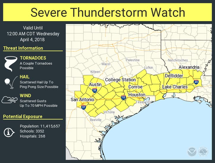
>>> Graphic above via National Weather Service
Get more local news delivered straight to your inbox. Sign up for free Patch newsletters and alerts.


