Weather
Bombogenesis, Bomb Cyclone, Polar Vortex: Weather Terms Explained
Scary weather along the Eastern Seaboard brings terms just as frightening — "bombogenesis," "bomb cyclone," "polar vortex" and others.

The weather outside really is frightful in many places in America, and the terms we’re hearing to describe the system moving up the Eastern Seaboard — “bomb cyclone,” “bombogenesis,” “polar vortex” and the like — aren’t helping.
Some, but not all, may be weather hyperbole. We’ve unraveled the mystery for you. Here are some questions and answers:
What is “bombogenesis”?
Find out what's happening in Across Americafor free with the latest updates from Patch.
Yikes, is this the end of days? No, it’s an actual meteorological term derived from the words "bomb" and "cyclogenesis” to describe an explosively strengthening storm. As the National Oceanic and Atmospheric Administration explains it, a bombogenesis occurs when a midlatitude cyclone rapidly intensifies, dropping at least 24 millibars — a measure of atmospheric pressure — over a 24-hour period. Still confused? Basically, as a giant column of air spinning counterclockwise over the Northern Hemisphere rises, it creates a vacuum effect that lowers atmospheric (or barometric) pressure, AccuWeather explained in a news release. As it increases in velocity, the pressure within the storm storm lowers. What defines bombogenesis isn’t the low pressure, but how quickly the pressure takes a nosedive.
What is a “bomb cyclone”?
Find out what's happening in Across Americafor free with the latest updates from Patch.
Yikes again, should we duck and cover? Bombogenesis is the process that forms what is called a “bomb cyclone.” A cyclone, a low-pressure rotating storm system, sees a dramatic drop in atmospheric pressure over a short period of time. These storms draw colder air from the north and bring a blast of frigid temperatures. You might also hear it referred to as a “weather bomb” or simply a “bomb.” A “bomb cyclone” sounds like a hurricane, and it has the strength of one and is capable of causing coastal flooding and heavy snow.

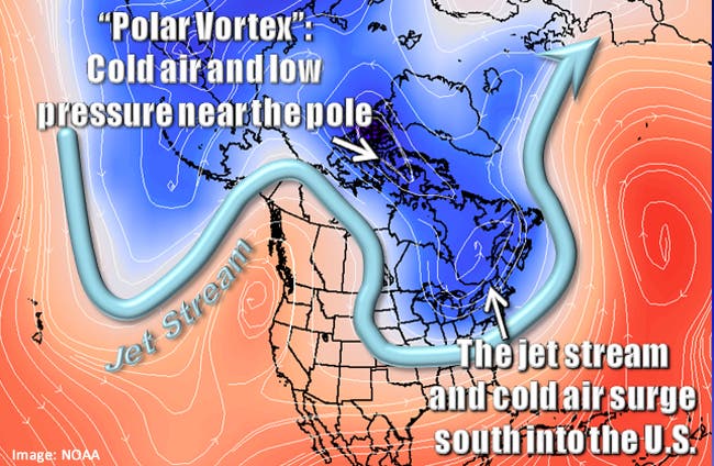
What is a polar vortex?
You could just call it ridiculously cold. You wouldn’t be wrong. A polar vortex is a vast low-pressure system of frigid air that spins around like a wheel. The Arctic air usually stays where it belongs — around the North and South Poles, where it is constantly swirling in a counter-clockwise motion known as a vortex keeps it where it belongs. Occasionally, the polar vortex expands and it dips down and causes extreme cold in parts of the lower 48 states, as it did in 2014, 1989, 1985, 1982 and 1977. With the exception of 2014, you might not have heard these extreme blasts of cold referred to as a polar vortex, because the term has only recently been popularized. The current storm is giving people as far south as Florida a taste of what it’s like to live “up north.”
What is an Arctic blast?
You probably want to put on extra layers the minute you hear the term, and if an Arctic blast is headed your way, you should. It’s a slightly sexier term to describe the boundary or front separating deep, cold Arctic air from shallower, relatively less cold polar air.
What is a snow eater?
Your snowblower? Uhm, no, and when a snow eater moves in, you won’t need it. It is a phrase to describe Chinook winds, the unseasonably warm winds that bring a rapid rise in temperatures in a few hours, according to AccuWeather.com. The easterly winds rise over the western slopes of the Rocky and Sierra mountains, then descend, eating up the snow and humidity and bringing in extremely dry, warm air. Sometimes, Chinook winds can cause a 40-degree rise in temperatures in a matter of minute and snow literally vanishes.
What is thundersnow?
You had to ask? Thunder snow is simply thunder and lightning that that occur during a snowstorm. It can be scary, because lightning strikes are as dangerous in the winter as they are in the summer. The big disadvantage is that in blinding snowstorms, you may not be able to see the lightning.
A pedestrian crosses the street in Harlem during a snow storm on Jan. 4, 2018, in New York City. As a major winter storm moves up the Northeast corridor, New York City is under a winter storm warning and forecasts are calling for 6 to 8 inches of snow. (Dia Dipasupil/Getty Images News/Getty Images)
Get more local news delivered straight to your inbox. Sign up for free Patch newsletters and alerts.