Weather
Severe Thunderstorm, Flood Watches Issued: DC, NoVA Weather
The National Weather Service issued severe thunderstorm and flood watches for D.C. and Northern Virginia Tuesday into the evening.

Updated at 2:30 p.m.
VIRGINIA — The National Weather Service has added a severe thunderstorm watch until 10 p.m. to its weather warnings for the region. A flood watch for Washington, D.C., and Northern Virginia is in place from 4 p.m. to midnight on Tuesday.
The thunderstorm watch is in effect for the District of Columbia, Prince William, Manassas, Manassas Park, Fairfax, Arlington, Falls Church, Fairfax City, Fredericksburg, Alexandria, Fauquier, Loudoun, Stafford, Spotsylvania and King George.
Find out what's happening in Arlingtonfor free with the latest updates from Patch.
The scattered severe thunderstorms are expected to arrive after hot and more humid air moves into the D.C. area Tuesday morning and afternoon.
"Hot and humid weather is back and it's bringing a severe weather threat along with it," NBC4 meteorologist Chuck Bell said Tuesday morning. "Storms likely to impact the PM commute in Metro DC with damaging wind gusts and localized flash flooding possible in the areas that had the heaviest rain last Saturday."
Find out what's happening in Arlingtonfor free with the latest updates from Patch.
Thunderstorms could drop "a quick inch of rain" on areas that were hammered with heavy rain last Saturday, including the 4.05 inches that fell at Reagan National Airport, Bell said.
With the storms, excessive rainfall may cause the flooding of rivers, creeks, streams and other low-lying and flood-prone locations, the NWS said.
Damaging wind gusts and large hail are also "primary threats," the NWS said, noting that an isolated tornado is possible.
The flash flood watch is in effect for areas of Northern Virginia as far south as Prince William County. The watch is not in effect for the Fredericksburg area.
In its forecast, The Washington Post's Capital Weather Gang said that after temperatures climb into the low-90s on Tuesday, scattered storms are likely. Some of the storms could be strong to severe, with damaging gusts.
"The timing of these storms could be critical for the evening drive, with a risk for slower-than-normal traffic from heavier rainfall," AccuWeather Senior Meteorologist Matt Rinde said Tuesday morning. Airports could also face flight delays and cancellations.
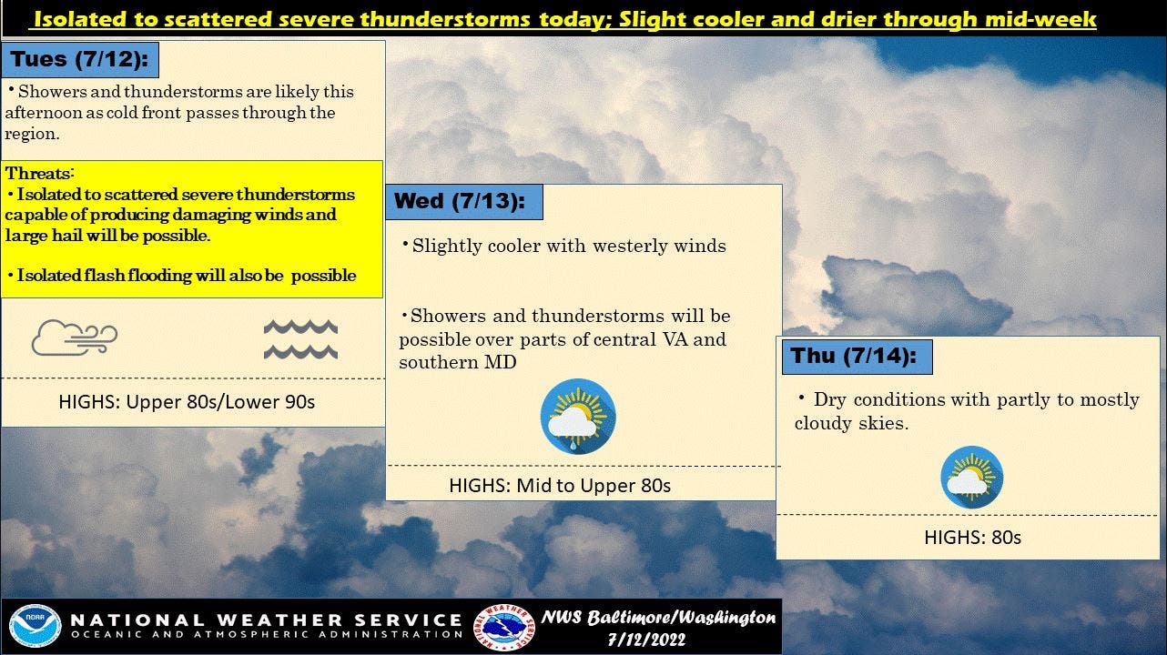
Here's the NWS forecast for D.C. and the Virginia suburbs for the next few days:
Tuesday: Scattered showers and thunderstorms, then showers likely and possibly a thunderstorm after 5pm. Some of the storms could produce small hail, gusty winds, and heavy rain. A high near 92.
Tuesday night: Showers likely and possibly a thunderstorm before 8 p.m., then a chance of showers and thunderstorms between 8 p.m. and 2 a.m. Some of the storms could produce small hail, gusty winds, and heavy rain. Mostly cloudy, with a low around 71.
Wednesday: Mostly sunny, with a high near 88.
Wednesday night: Partly cloudy, with a low around 70.
Thursday: Mostly sunny, with a high near 86.
Thursday night: Partly cloudy, with a low around 69.
Friday: A chance of showers and thunderstorms after 2 p.m. Mostly sunny, with a high near 83.
Get more local news delivered straight to your inbox. Sign up for free Patch newsletters and alerts.