Community Corner
Hurricane Joaquin's Path Shifts to the East of DC Metro Area
As current forecast by National Hurricane Center predicts, DC metro area is not in the direct path of Hurricane Joaquin.

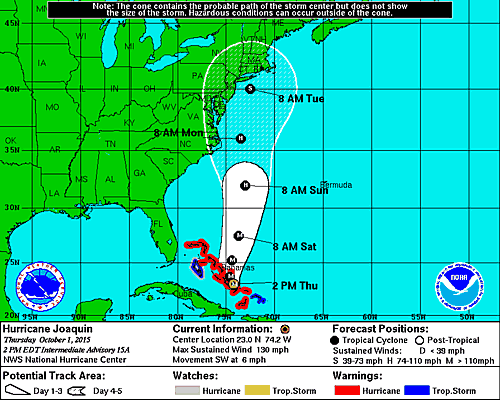


MAP: National Hurricane Center map as of 2 p.m. Thursday shows path of Hurricane Joaquin shifting to the east, away from DC metro area.
_____________
UPDATE: 4 p.m. A strengthening Hurricane Joaquin is now an “extremely dangerous” Category 4 storm, packing winds of 130 MPH, according to the National Hurricane Center. Central Bahamas will experience hurricane force winds through tonight, the Hurricane Center says.
Find out what's happening in Arlingtonfor free with the latest updates from Patch.
Some additional strengthening is possible during the next 24 hours, with some fluctuations in intensity possible Friday night and Saturday. Forecasters say the DC metro area will likely several inches of rain from the storm, after the Nor’easter expected Friday and Saturday.
Forecasters say it will dissipate to a Category 1 by Monday off the coast of the Carolinas. Beach erosion from the hurricane is a potential problem officials are concerned with along Virginia and Maryland coastlines.
Find out what's happening in Arlingtonfor free with the latest updates from Patch.
______________
Forecasters are now predicting that Hurricane Joaquin’s path will shift to the east of the D.C. metro area, according to the most recent report Thursday morning from the National Hurricane Center.
Forecasters have not yet said how much rain the area might still get from the hurricane Sunday and Monday, but the area is currently under a flash flood watch Friday and Saturday, ahead of the hurricane.
Hurricane Joaquin continues to gain strength Thursday morning, with maximum sustained winds near 120 MPH winds, with higher gusts, according to the National Hurricane Center report. The hurricane is a Category 3. For the hurricane to become a Category 4, it would need to reach maximum sustained winds of 131 MPH.
Its impact on the DC metro area is still uncertain, forecasters say.
- Flash Flood Watch Issued for Region
- State of Emergency Declared Ahead of Nor’easter
- How to Be Hurricane-Ready
Some strengthening is forecast in the next day or so, with some fluctuations in intensity possible on Friday, according to hurricane forecasters. Hurricane-force winds extend outward up to 35 miles from the center and tropical storm force winds extend outward up to 140 miles.
The National Hurricane Center cautions in its report Thursday morning that:
- Because landfall, it it occurs, is still more than three days away, it’s too early to talk about specific wind, rain or surge impacts from Joaquin in the United States.
- A hurricane watch for a portion of the U.S. coast could be required as early as tonight.
- Many portions of the eastern U.S. are currently experiencing heavy rains and gusty winds associated with a frontal system.
Location and path
At 8 a.m., the center of Hurricane Joaquin was located near latitude 23.2 North, longitude 73.7 West. Joaquin is moving toward the west-southwest near 5 mph, and this motion is expected to continue Thursday, according to the National Hurricane Center.
A turn toward the west- northwest is forecast tonight, followed by a turn toward the north and an increase in forward speed on Friday. On the forecast track, the center of Joaquin will move near or over portions of the central Bahamas Thursday and Thursday night, and pass near or over portions of the northwestern Bahamas on Friday.
Bahamas
A Hurricane Warning is up for the Central Bahamas. A Hurricane Warning means that hurricane conditions are expected somewhere within the warning area. Preparations to protect life and property should be complete in the central Bahamas. A Hurricane Watch means that hurricane conditions are possible within the watch area. A Tropical Storm Warning means that tropical storm conditions are expected somewhere within the warning area.
Joaquin is expected to produce total rain accumulations of 10 to 15 inches over the central Bahamas with isolated maximum amounts of 20 inches are possible. Rainfall amounts of 5 to 10 inches are expected over the southeastern Bahamas with 2 to 4 inches over the northwestern Bahamas. This rainfall could result in life-threatening flash floods.
Swells generated by Joaquin will affect portions of the Bahamas during the next few days, and will begin to affect portions of the southeastern coast of the United States today and spread northward through the weekend. These swells are likely to cause life-threatening surf and rip current conditions.
Get more local news delivered straight to your inbox. Sign up for free Patch newsletters and alerts.