Weather
NoVA, DC Weather: Flood Watch Issued As Heavy Rains Move In Monday
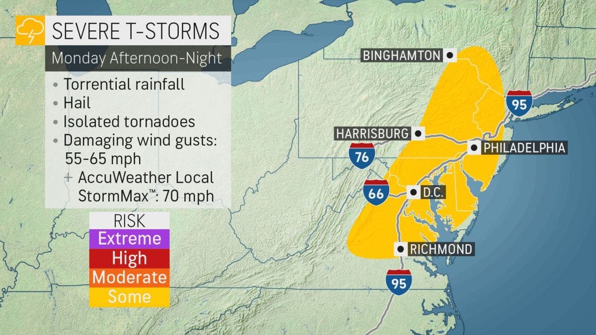
The National Weather Service issued a flood watch for DC and parts of Northern Virginia, as up to 3 inches of rain is forecast for Monday.

VIRGINIA — The National Weather Service has issued a flood watch for Washington, D.C., and parts of Northern Virginia as up to 3 inches of rain could fall in the region Monday afternoon and evening.
The flash flood watch is in effect from 5 p.m. to midnight Monday for D.C., plus Fairfax County, Arlington County, Falls Church, Alexandria, Loudoun County and Prince William County.
Showers and thunderstorms are expected Monday afternoon into the evening as a cold front pushes through the area. Heavy rainfall rates could produce localized rainfall amounts of 2 to 3 inches in a short period of time.
Find out what's happening in Arlingtonfor free with the latest updates from Patch.
Excessive runoff may result in flooding of rivers, creeks, streams, and other low-lying and flood-prone locations, the NWS said.
Residents should monitor forecasts and be prepared to take action should flash flood warnings be issued, according to the weather service.
Find out what's happening in Arlingtonfor free with the latest updates from Patch.
Forecasters at AccuWeather said damaging winds will be one of the hazards from any severe storms in the Mid-Atlantic area, though forecasters note that hail and even a few tornadoes also cannot be ruled out.
"The highest tornado threat should line up with where the strongest winds above the surface are found. For Monday, this will likely be in the northern half of the threat area, from the D.C. metro area northward," AccuWeather meteorologist Andrew Johnson-Levine said.
The Washington Post's Capital Weather Gang said showers and storms become more probable across the region Monday evening, and "some could be intense, producing a few pockets of flooding." Like AccuWeather, Capital Weather Gang forecasters said there is a chance of a brief tornado from the storms.
"Today is a 'WEATHERALERT' day with a risk of severe storms and flash flooding," NBC4 meteorologist Chuck Bell said in a tweet Monday morning. "After that, September sunshine and low humidity will take over and hold on tight for the rest of the week."
Here's the NWS forecast for DC and Northern Virginia for the next few days:
Monday: Scattered showers and thunderstorms between 2 p.m. and 5 p.m., then showers and possibly a thunderstorm after 5 p.m. Some of the storms could produce small hail and gusty winds. High near 84.
Monday night: Showers and thunderstorms, mainly before 11 p.m. Some of the storms could produce small hail, gusty winds and heavy rain. Low around 66.
Tuesday: Mostly sunny, with a high near 80.
Tuesday night: Mostly clear, with a low around 60.
Wednesday: Sunny, with a high near 81.
Wednesday night: Clear, with a low around 63.
Thursday: Sunny, with a high near 81.
Thursday night: Clear, with a low around 59.
Get more local news delivered straight to your inbox. Sign up for free Patch newsletters and alerts.