Community Corner
Tropical Storm Joaquin Forms, Could Impact Northern Virginia
Northern Virginia is included in National Hurricane map showing possible trajectory of storm over the weekend.

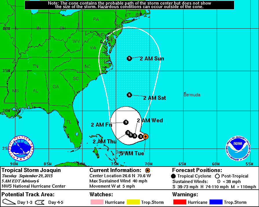
MAP: Issued by the National Hurricane Center at 5 a.m. Tuesday, map shows Tropical Storm Joaquin’s possible path could impact Northern Virginia over the weekend.
_____________
The trajectory of a newly formed Tropical Storm Joaquin, pinpointed in the Atlantic Ocean by the National Hurricane Center, shows it could impact Northern Virginia over the weekend.
Find out what's happening in Arlingtonfor free with the latest updates from Patch.
A forecast map issued by the National Hurricane Center at 5 a.m. Tuesday shows Joaquin moving westward about 385 miles northeast of the central Bahamas with maximum sustained winds of 40 MPH, with higher gusts. The forecast for the storm’s trajectory shows an area that includes Northern Virginia.
Find out what's happening in Arlingtonfor free with the latest updates from Patch.
“Depending on [Tropical Storm Joaquin’s] exact track, which is highly uncertain, heavy rain could impact coastal areas anywhere from the Mid-Atlantic to southern New England and even expand inland west of the I-95 corridor,” The Washington Post’s Capital Weather Gang said in a post Monday night.
“In addition to the rain, coastal areas could also face gusty winds, high surf, beach erosion and flooding — depending on how the system evolves,” the Gang noted.
There are currently no coastal watches or warnings.
At 5 a.m., the center of the storm was located near latitude 26.6 North, longitude 70.6 West. Joaquin is moving toward the west near 5 mph, and this general motion is expected to continue through Wednesday. A decrease in forward speed and a turn toward the west-northwest are forecast by Wednesday night.
Slow strengthening is forecast by the hurricane center during the next 48 hours. Tropical storm force winds extend outward up to 70 miles from the center.
Get more local news delivered straight to your inbox. Sign up for free Patch newsletters and alerts.