Health & Fitness
Impacts of Tropical Storm Andrea
Local impacts of Tropical Storm Andrea over our region
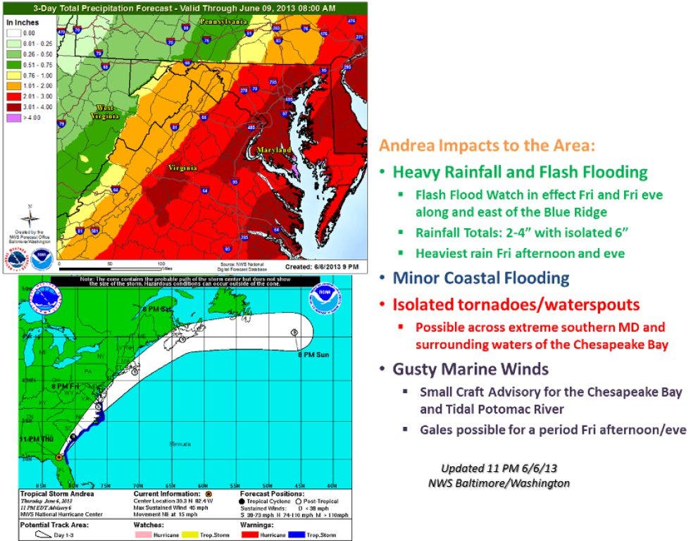
Tropical Storm Andrea will become a post-tropical storm within 24 hours as it continues to move northeast bringing tropical moisture to the area. The major concern from this system is heavy rainfall that may produce flash flooding. The National Weather Service has issued a flash flood watch* until 10pm Friday June 7th.
The greatest impacts from rainfall are expected Friday afternoon and evening as the storm moves near the mount of the Chesapeake Bay. Precipitation chances will decrease overnight as the system continues to moves away from our region. Rainfall totals will be between one to four inches, with possible isolated totals of six inches, especially near and east of I-95.
Winds will be between 8 and 15 mph, with possible gusts up to 20 mph.
Find out what's happening in Fredericksburgfor free with the latest updates from Patch.
The National Weather Service Baltimore/Washington has also issued a hazardous weather outlook that includes a coastal flood advisory** for the Tidal Potomac River and a small craft advisory*** for the waters. A gale warning**** may be needed for portions of the waters Friday afternoon and evening, especially for the Lower Tidal Potomac River.
Isolated tornadoes or waterspouts cannot be ruled out over the Lower Tidal Potomac River.
Find out what's happening in Fredericksburgfor free with the latest updates from Patch.
For official information please visit:
------------
*A flash flood watch means that conditions may develop that lead to flash flooding. Flash flooding is a very dangerous situation. You should monitor later forecasts and be prepared to take action should flash flood warnings be issued.
**A coastal flood warning means that moderate or major coastal flooding is likely. Moderate coastal flooding produces widespread flooding of vulnerable shore roads and/or basements due to the height of storm tide and/or wave action. Numerous road closures are needed. Lives may be at risk for people who put themselves in harms way. Isolated structural damage may be observed.
***A small craft advisory means that wind speeds of 21 to 33 knots are expected to produce hazardous wave conditions to small craft. Inexperienced mariners...especially those operating smaller vessels should avoid navigating in these conditions.
****A gale warning means winds of 34 to 47 knots are imminent or occurring. Operating a vessel in gale conditions requires experience and properly equipped vessels. It is highly recommended that mariners without the proper experience seek safe harbor prior to the onset of gale conditions.