Weather
Hurricane Ian: How Could The Storm Impact VA?
Will Virginia see the impacts of the hurricane expected to bring damaging winds to the southeast? Here's when VA could see remnants of Ian.


VIRGINIA — Devastating wind damage, life-threatening storm surges, and flash floods are expected in Florida late Tuesday and Wednesday as Hurricane Ian barrels toward the southeastern U.S. states and is likely to upgrade to a Category 4 storm, according to the National Hurricane Center.
After the storm makes landfall in Florida, experts expect it to weaken before moving up the east coast. It's still too early to know the exact effects of Ian in our region.
AccuWeather meteorologists are currently monitoring the forward speed of Ian after landfall in Florida, which may determine its path in the rest of the U.S.
Find out what's happening in Fredericksburgfor free with the latest updates from Patch.
"Ian will slow down over the Southeast states, but as long as it maintains some forward speed, rainfall will be heavy but not over the top," AccuWeather Senior Meteorologist Alex Sosnowski said. "However, if Ian stalls over the Southeast for a day or two, there is the potential for much heavier rainfall to fall over a broad area, including interior locations."
According to Accuweather's hurricane tracker, the remnants of Ian could reach Virginia over the weekend and into next week. At that point, experts believe the hurricane would be downgraded from a hurricane to a "tropical rainstorm."
Find out what's happening in Fredericksburgfor free with the latest updates from Patch.
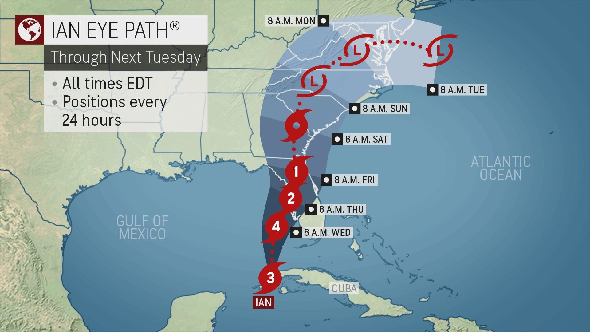
"For the weekend and even into Monday, a great deal of uncertainty remain regarding the track of Hurricane Ian," the National Weather Service said in its forecast discussion for Northern Virginia. "What does seem certain at this point is that our region should at least see some rainfall from Ian Saturday into Sunday."
Still, experts noted that the extent of Ian's effects on our area remains to be seen.
"Whether that is a beneficial or hazardous amount [of rain] has yet to be seen," the National Weather Service said. "We will continue to monitor the forecast for Ian and adjust the forecast as needed."
Stay up-to-date by viewing all Hurricane Ian coverage on Patch here.
Here's the latest forecast for the Northern Virginia region:
- Tuesday: Sun mixing with clouds. Highs near 75 with low temperatures around 50.
- Wednesday: Partly sunny with high temperatures in the low 70s and lows around 52.
- Thursday: Sunny and windy. Wind gusts could reach 13 miles per hour from the northeast. High temperatures near 69 with lows around 59.
- Friday: Dry conditions with high temperatures in the mid to upper 60s.
- Saturday: Chance of rain begins. Highs near 70 with lows around 60.
- Sunday: 90 percent chance of rain as a tropical rainstorm reaches the area. Wind gusts could exceed 30 miles per hour. High of 66 with an expected low in the mid 50s.
- Monday: More rain from the remnants of Ian. Wind gusts near 30 miles per hour. High temperature of 70 with a low of 52 at night.
Get more local news delivered straight to your inbox. Sign up for free Patch newsletters and alerts.