How did Elden Street get its name? The short answer is: We are not 100 percent sure, but we do have some information that gives us some hints.
Over 200 years ago Ferdinando Fairfax sold 370 acres of land in the downtown Herndon area to members of the Coleman family. Some deeds are missing from this time period, which makes some information spotty.
Oral history regarding the origin of Elden Street has been passed down in Herndon through the years. The gist of the oral history goes like this:
Find out what's happening in Herndonfor free with the latest updates from Patch.
“A man named Colonel John Coleman, a Revolutionary War veteran, built the first home in Herndon in 1776. He named his home Elden and he also gave Herndon’s main street that same name.”
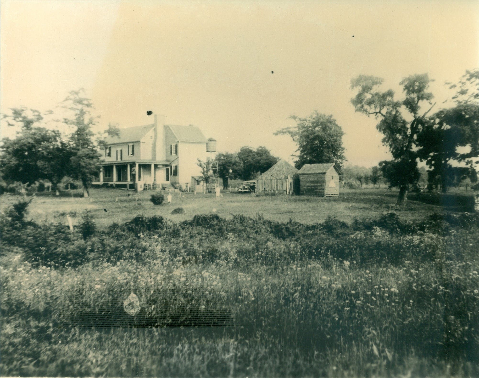
Coleman’s house formerly sat in the area behind (just southeast of) Herndon Middle School in the vicinity of the present day Lifestyle Condominiums. But the problem with part of the oral history story is that Herndon’s main street did not exist in John Coleman’s time.
Find out what's happening in Herndonfor free with the latest updates from Patch.
We believe the source of this oral history story was Kathryn “Kitty” Kitchen Hanna (1830 to 1907) who lived in Herndon for the majority of her life. In 1905-1906, Kitty was interviewed by Virginia Castleman to document a first-hand account of her life in Herndon. The book is entitled “Reminiscences of an Oldest Inhabitant, A Nineteenth Century Chronicle.” In that book Kitty is quoted as saying:
“Susan Critcher, my great grandmother’s stepdaughter, married John Coleman, same as built Elden place years ago, and named the main street of this town.”
Herndon history stories that have been written over the years have repeated this same story about how Revolutionary War veteran, Col. John Coleman, built and named the house, and the road. End notes in the “Reminiscences” book, which were written by other local Herndon residents in the 1970s, refer to the Coleman home this way:
“The house that was erected in 1776 by Colonel John Coleman and known through the years as Elden, the Coleman place, the Bowers place … was taken down when the International Apartments and Jefferson Mews was built.”
Unfortunately, there are some other potential inconsistences with the oral history story. For example, it was James Coleman – John Coleman’s father – who was the Revolutionary War Colonel, not John. Also, one has to question why James Coleman would have built a home in 1776 while he was serving in the Revolutionary War. Additionally, ancestry documents indicate that James’s son, John, lived from circa 1764 to 1813, which would have put his age at approximately 11 to 19 years old during the war, so the chances that John built the house at that age (or in 1776) also seems unlikely.
Moreover, deeds indicate that father and son — James and John Coleman — bought the land in question from Ferdinando Fairfax in 1803-04, not in the 1700s. However, it is possible that the Colemans could have been renting the land and built a home there prior to their purchase of the land.
John Coleman did marry a woman named Susan (formally Susannah) Critcher in 1788. But his father, James Coleman, also married a Critcher – Jean[e] Critcher. Could it be that Kitty simply mixed up James with John, or Jean[e] Critcher with Susan Critcher? Or might John Coleman have built the house later, after he married Susan? These Colemans and Critchers were all people who lived many generations before Kitty was interviewed in 1905-1906.
On the face of it, it appears that Kitty clearly credits the naming of Elden Street to John Coleman. But could it be that Kitty was referring to the name “Elden place” in her own present time when she was being interviewed in 1905-1906?
The northern boundary of Coleman’s property ran along what is now Elden Street. Could the street have been named Elden Street later, named after the Elden house, since the street abutted the property on which the house sat? Here we have “the chicken or the egg” dilemma: Did Coleman build his house along an existing roadway that he later named Elden Street? Or did Coleman build his house first and then the pathway which lead up to the Coleman’s house formed later and became known as “the road that leads to Elden place?”
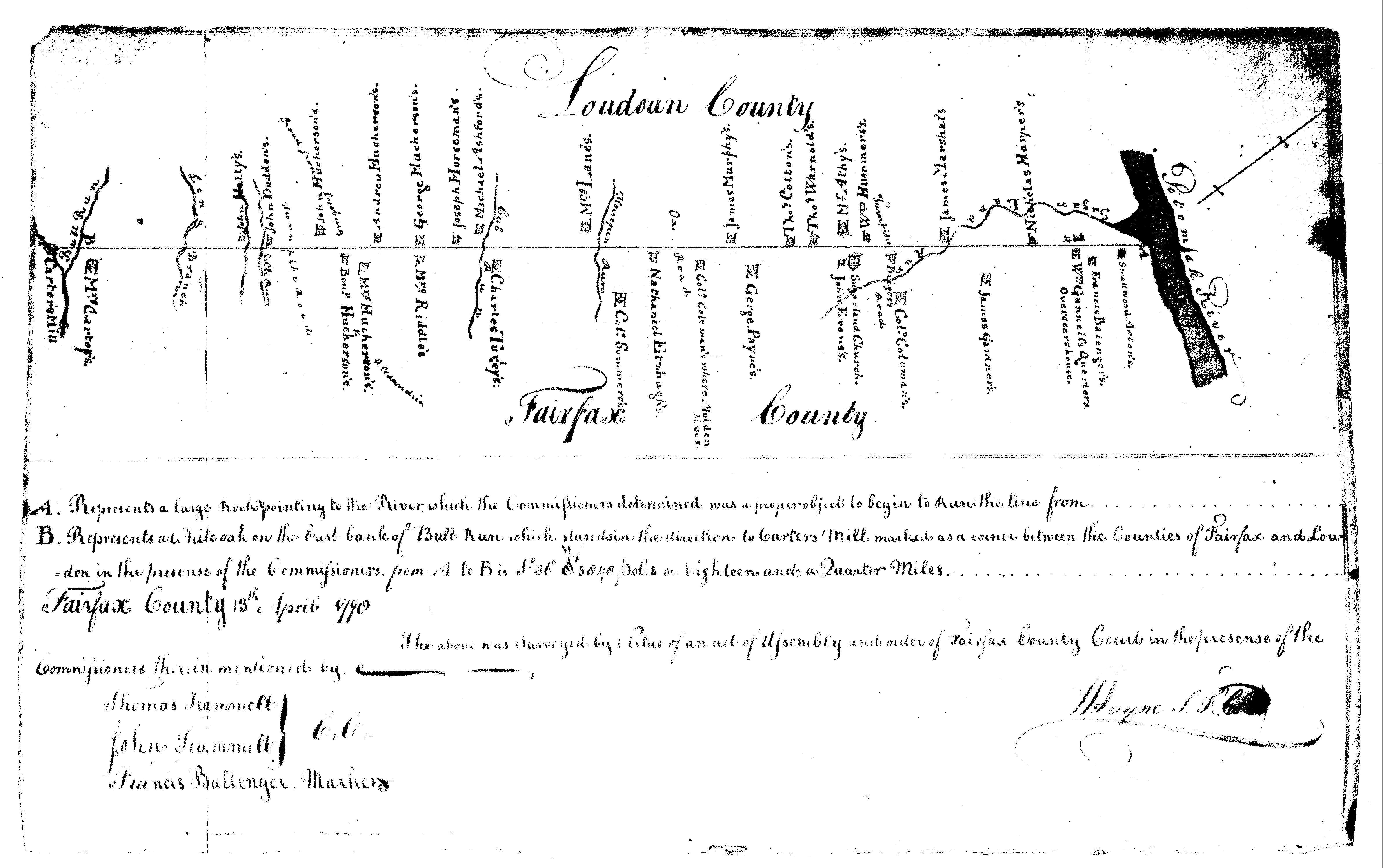
We have discovered a survey map dated 1790 which has few topographical details. It marks the Potomac River and the boundary line between Fairfax and Loudoun counties. We took note of three homes that were marked on the map. One is George Payne’s house, which still stands on Dranesville Road in Herndon today. The next home south of that is marked “Col. Coleman’s where Molden lives.” Just south of that house is a short line to mark Ox Road. “Ox Road” likely refers to today’s Old Ox Road, Route 606, a portion of which is called Sterling Road in Herndon.
Although the map is near featureless map, it appears the house marked as “Col. Coleman’s” is in the approximate vicinity of where the Elden house would have been, so the map lends credence to the assertion that the home was built in the 1700s, at least as far back as 1790. The wording seems to indicate someone named Molden may have been renting the home. But was it the Coleman family who named the house “Elden?” And did they name Elden Street as well?
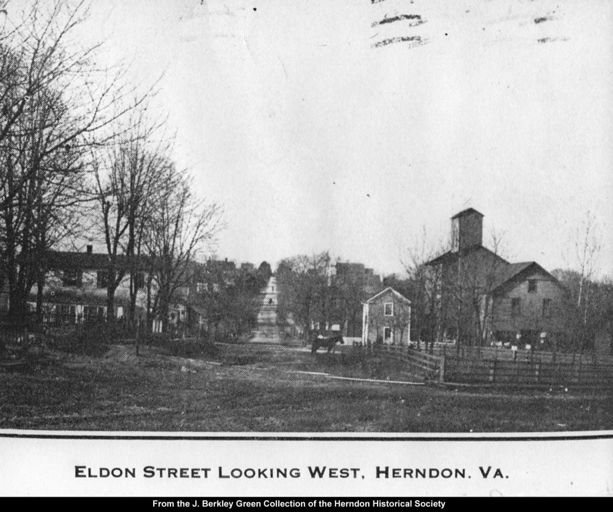
Over the last many decades this house was commonly known as the Elden (or Eldon) House, but it is not fully clear at what point in time the house, or its surrounding farm, obtained that name. Old deeds and captions on old photographs show the name being spelled two ways – Elden and Eldon. But the words Elden or Eldon only start appearing in deeds beginning in the mid-1800s. It is also unclear which spelling was the original spelling, when the spelling may have changed, or whether the two different spellings simply reflect a typo. However, one fact we do know is that the Town’s first official map drawn by cartographer G.M. Hopkins in 1878 shows that the main road that runs through the center of the town of Herndon is labelled “Elden Street.”
After James and John Coleman died in the early 1800s, the land passed down through members of the Coleman family, including James and Sarah Bland, and Samuel and Sara Coleman. The Coleman family had the land up until 1842. Later, portions of this land were sold to various people over the years, including Thomas J. Carper, Thomas and Elizabeth Cox, John McKelden, Ulysses Ward, Curtis and Anna Gilbert, Thomas A. King, Richard S. T. and Elizabeth Cissell, and J. Luther and Alice Bowers. The Bowers bought 165 acres of the land in 1886 and lived in the old Coleman house for many years.
Note that one of the previous owners was named John C. McKelden, whose name in various deeds and newspapers is occasionally spelled “McKeldon.” Thinking about word origins, the prefix “Mc” or “Mac” means “son,” therefore, “McKeldon” could mean “son of Keldon” or “son of Eldon.” Doing a quick Internet search it appears that Eldon is considered an Old English name that could have various meanings, including: “Ella’s hill,” or “from the elves valley,” or “from the old town,” or “the old homestead.” And the name Elden is a variation of Eldon. We will leave any further research on the etymology of that name to the readers.
John C. McKelden, born in Ireland in 1809, bought the old Coleman property in 1856 and then sold it in 1866. Could John McKelden have been the one who named the property “Elden?” Or is it just a coincidence that the McKelden’s name is very similar to the house and the street name?
For many years the house and the 165 acres of the old Coleman property that the Bowers owned after 1886 was often referred to as the Elden house and the Elden plantation. Many years later it became the Bower’s subdivision. The farm grew crops such as corn, wheat, barley and soy. At one point, Mr. J. Luther Bowers took a narrow 12-acre strip of the farm’s land (between Elden and Locust Streets) and formed a fruit farm, which was called “Eldenwood Fruit Farm.” The fruit farm ended up not being successful. By the 1890s, he subdivided the 12 acres and sold off the small individual lots, which now have homes on them. That subdivision is still called the Eldenwood Fruit Farm subdivision today. Could the name “Elden” have first appeared when J. Luther Bowers named his fruit farm in the late 1800s? One descendant of the Bower’s family could not be sure when the house or the street obtained the name Elden but speculated it could have possibly been named quite a long time after the house was first constructed.
Trying to document the earliest references to “Elden,” we have discovered there is no mention of the word Elden/Eldon in the Fairfax County Road Orders from 1749-1800. And the earliest newspaper articles that mention Elden/Eldon in the Herndon area do not appear until the late 1800s (Washington Post, Washington Evening Star, Alexandria Gazette, Fairfax Herald) where we find references to people buying/selling houses on Elden Street in Herndon in the 1890s. Those references were in association with the Eldenwood Fruit Farm, the time period in which J. Luther Bowers was selling off his subdivided land. Later, in the 1920s, additional references to Elden Street start appearing in the newspapers.
We also tried looking through old maps from the 1700s and 1800s to see if we could discover when Elden Street first appeared on maps. During Coleman’s day Little River Turnpike (now Route 50) and Leesburg Pike (Route 7) existed. The hamlet of Dranesville existed in the 1700s, long before the town of Herndon came into being. The main access to Dranesville was Route 7, which stretched from Alexandria to Leesburg.
Additionally, according to the book, Fairfax County, Virginia, A History, by Nan Netherington, et al.:
“As originally laid out in 1729 by Robert ‘King’ Carter, Ox Road ran from Occoquan to the Frying Pan Copper Mine on the Horse Pen Branch of Broad Run.”
The road that Netherington described ran to the Frying Pan area, which is now known as Floris. But that road did not run further north to Herndon, since Herndon did not yet exist. Instead, the road ultimately continued in a northwesterly direction, out toward Leesburg via the Goose Creek/Belmont area. Looking at various maps of the Herndon area, the Fairfax County area, the Northern Virginia area, and the state of Virginia, no maps dated between the 1700s and 1859 can be found that show any roads connecting Frying Pan (or Floris) to Herndon.
But that soon after changed. Maps from 1861 and later show a road leading from Frying Pan northward to Herndon Station (or train depot), which continued northward to Leesburg Pike. The road from Frying Pan to Herndon Station is what we now know as Centreville Road. At some unknown point in time, the section of that road that lies within the town of Herndon’s corporate limits came to be known as Elden Street. These 1860s maps did not have street names marked. We only see the pathway of what would be Elden Street.
Maybe not so coincidental is the fact that the Washington and Old Dominion (W&OD) Railroad (then the Alexandria Loudoun and Hampshire Railroad) was being constructed in the 1850s. The Herndon Depot is thought to have been built in 1857 and the Herndon Post Office opened inside the depot in 1858. Could this be the reason why a roadway was finally built between Frying Pan and Herndon Station? It is well known that the dairy farmers along Centreville Road used the W&OD railroad to ship their milk into Washington, D.C. Or could it be that the Civil War (1861-1865) had something to do with the road being constructed from Frying Pan to Herndon and then further on to Leesburg Pike?
In later deeds, the cut-through road that ran from Frying Pan to Herndon was often referred to as “the old county road.” Donald LeVine wrote a book in 1982 called, “Herndon, The Land: 1649-1900,” in which he tracked Herndon land deeds for that time period. References to Elden Street appeared in some of the land deeds ranging from 1858 to the 1890s. But there were also references to the “old county road” during that time period, which were obvious references to what we now know as Elden Street. For instance, an 1857 deed describes a section of Elden Street as “the County Road from Dranesville to Frying Pan Meeting House.” An 1861 deed refers to the “county road leading to Frying Pan Church and to corner to Br[e]ady,” which is also a reference to today’s Elden Street and Centreville Road leading to Mayor Bready’s property in Herndon, near Elden Street and Ferndale Avenue. In 1870 there was a reference to “the old county road leading through Herndon.” These “county road” references appear in deeds that range from 1850 to 1896. A Bowers subdivision map, dated 1911, labels Elden Street as “County Road to Floris." A deed as late as 1921 still referred to Elden Street as “the county road.”
However, there were also some references to “Elden Street” in deeds that range from 1858 to 1900. Additionally, there were some deeds that referred to both names. For example, an 1875 deed made a reference to “old County Road or Elden Street.”
Therefore, it appears that the time frame that stretched from the mid-1850s to 1900 was possibly a transition period when the road was being referred to as both Elden Street and “old County road.” And, as mentioned earlier, the 1878 Hopkins map labelled the road Elden Street, just one year before the Town was incorporated.

It is believed that between 1810 and 1840 there were only four homes that existed within what are now the corporate limits of the Town of Herndon. A lumber mill and the railroad depot were built in the mid-1850s which helped spur the growth of the Town. Prior to that Herndon was predominantly vast open land. No deeds can be found which make any references to Elden Street prior to the 1850s. Is it just coincidental that the Elden Street name starts appearing in deeds at about the same time that the railroad depot was built and when John McKelden owned the Elden house from 1856-1866?
Questions remain: if John Coleman bought the property in 1803-04 (or possibly built a house in 1776), and if he supposedly named our main road Elden Street, and if the property was sold out of his descendants’ possession in 1841, how come there are no official references to Elden Street in the late 1700s and up to the 1850s? Could it be that the Coleman’s (or other later residents) simply informally called the road Elden Street because it was the roadway that lead to the Elden house That is, “the road that leads to the Elden house” eventually become known as “Elden Street?” It was not uncommon for early roads or intersections to be informally named after properties and/or their owners, since many early dirt roads had no official names. Or did the road not get its name until years later when John McKelden owned the land?
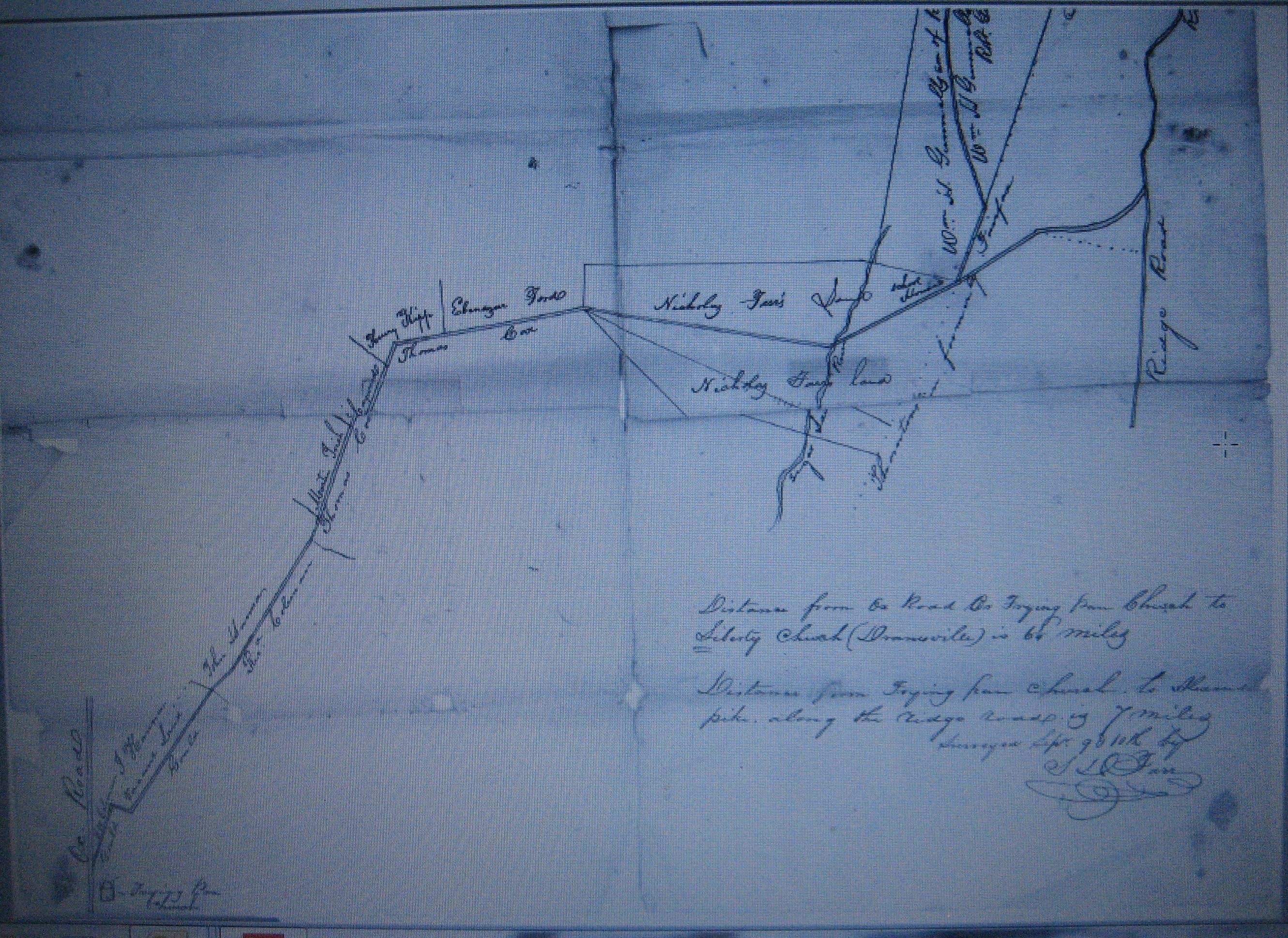
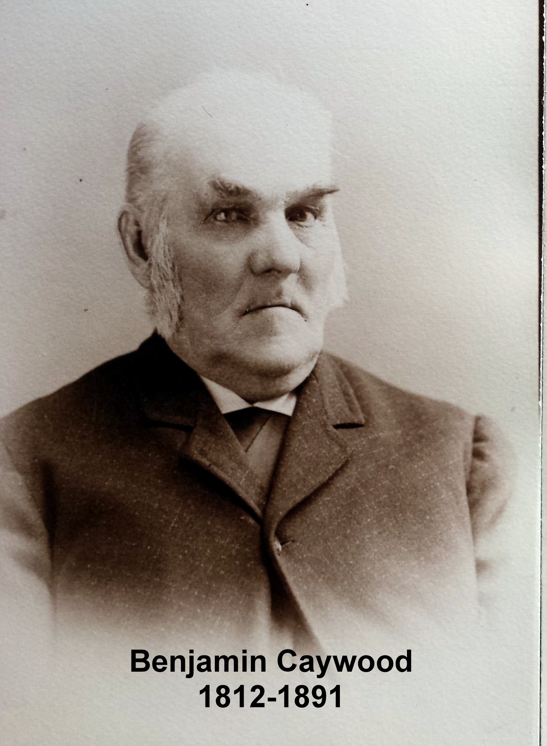
The recent discovery of the origins of Elden Street came in the form of a Fairfax County road order petition dated 1851. In 1851 Benjamin Caywood petitioned the county for a road “from Frying Pan Church to Liberty Church.” The Frying Pan Meeting House Church is located on Centreville Road in Floris. The Liberty Church was located off of Leesburg Pike (Route 7), between the present location of Fairfax County Parkway and Reston Parkway. The plat map associated with Caywood’s petition shows the pathway of the proposed road going right through what is now Herndon, the pathway of today’s Elden Street. The petition was granted in 1852. How long it took to actually build the road is unknown, but now we know that the formal road was not constructed until after 1852. And, as mentioned earlier, the road starts showing up on maps in the early 1860s.
Benjamin Caywood moved to Herndon in 1949, investing in 200 acres of land. He was a prominent citizen who farmed and also worked in real estate. His home was located on south Elden Street, near the present day intersection of Elden Street and the Herndon Parkway.
In the 1840s there were no local connections between the two existing main east-west thoroughfares, Little River Turnpike (Route 50) and Leesburg Pike (Route 7). In 1847 a group of local merchants and bankers chartered the Alexandria and Harper’s Ferry (A&HF) Railroad which was planned to go through Herndon. That initial railroad endeavor ended up not being successful. However, the Alexandria, Loudoun and Hampshire Railroad (AL&H) came soon after. Could it be that Mr. Caywood — who came to Herndon during this time period — anticipated the economic future and benefits of the coming rail, which prompted him to petition for a road through Herndon in 1851? His proposed road would connect Floris to the railroad station in Herndon and then onto the already vibrant Dranesville area where the mega-thoroughfare of Leesburg Pike was located.
One Caywood descendent, who has done extensive research on family history, said he could not find the name “Elden” associated within any family genealogies. Nor could he find any place named Elden in Orange or Ulster Counties in New York, where the family ancestors had originated. Therefore, it does not seem likely that the name “Elden” was associated with the Caywood family.
At the time Caywood’s petition was initially approved in 1852, Thomas Cox owned the land that included the old Coleman house (Elden House). However, in 1856, Cox sold the land to John McKelden. McKelden owned the land until 1866.
Looking into John McKelden’s family history we find that he was born in 1809 in County Monaghan in the Province of Ulster in Northern Ireland. The surname Eldon has Anglo-Saxon origins. According to The Oxford Dictionary of Family Names in Britain and Ireland, in the mid-1800s the name could be found in both Great Britain and Ireland. The main Irish location for the name Eldon (of which Elden is a variant) was in the town of Armagh. Armagh is also located in Northern Ireland, just 10 miles away from Monaghan, John McKelden’s birthplace. Conversely, the Coleman family ancestry is rooted in Virginia, as far back as the 1600s, with no known associations to the name “Elden.”
The 1851 road petition likely explains why Elden Street does not start showing up in maps until the early 1860s. (The road could have been built in the 1850s and then started showing up on maps in the early 1860s). As said before, early 1850s deeds refer to the road as the “county road.” However, in the late 1850s references to “Elden Street” start appearing in deeds. And, as also previously mentioned, all this happened to be the time period when John McKelden owned the land along what is now Elden Street that, much later, would become the Bower’s property.
Clearly, the house on the property was known as Elden, at least for the last 125 years, back to at least the Bower’s time at the house. Was our main street named by John (or James) Coleman as Kitty Kitchen alluded, or by somebody else later on? Or did the road somehow naturally become known as Elden Street due to its close proximity to the Elden house and its surrounding farm? Was the house built and named by John (or James) Coleman as Kitty claimed? Or was the house named by John McKelden? Certainly some kind of pathway must have led on and off McKeldon’s (and Coleman’s) property. Could that pathway have been known in its early years as the road that led to the McKeldens? Could it have later morphed into being called the McKelden road? Or later, the Elden Road/Street?
At this point we are not one hundred percent sure of the answers to these question, nor are we sure why the word Elden was selected. The oral history origins of the name of Elden Street seem to be based predominantly on Kitty’s recollections in 1905-1906. Parts — or all — of her story could possibly be true. Or not.
The house was built by members of the Coleman family, but it is in doubt if they were the ones who named the house, and subsequently the street, “Elden.” It is plausible that the house was called Elden and the street was later named after the house. However, it is also very plausible that the name “Elden” came about in the 1850s when the road was built, when John McKelden owned the house and the adjacent land to the road.
The truth is, the details about how the name Elden Street came about are still not fully clear and a sense of mystery still surrounds it.
About this column: “Remembering Herndon’s History” is a regular Herndon Patch feature offering stories and anecdotes about Herndon’s past. The articles are written by members of the Herndon Historical Society. Barbara Glakas is a member. A complete list of “Remembering Herndon’s History” columns is available on the Historical Society website at www.herndonhistoricalsociety.org.
The Herndon Historical Society operates a small museum that focuses on local history. It is housed in the Herndon Depot in downtown Herndon on Lynn Street and is open every Sunday from 12 noon until 3 p.m. Visit the Society’s website at www.herndonhistoricalsociety.org, and the Historical Society’s Facebook page at https://www.facebook.com/HerndonHistory for more information.
Note: The Historical Society is seeking volunteers to help keep the museum open each Sunday. If you have an interest in local history and would like to help, contact HerndonHistoricalSociety@gmail.com.
Get more local news delivered straight to your inbox. Sign up for free Patch newsletters and alerts.