Weather
Below-Zero Wind Chills, Snow Squalls In Brutal Weekend Forecast: NoVA Warnings Issued
Brutal temperatures, high winds and snow are expected to return to Northern Virginia Friday night and into the weekend. See the forecast.

An Arctic front is set to hit Northern Virginia this weekend, bringing brutally cold temperatures, high winds, and snow to the D.C. region.
The direct blast of frigid air will surge south Friday into Saturday, affecting more than 100 million people across multiple states, including Virginia. The harshest conditions are expected during the first half of the weekend, with snow and the strongest winds accompanying the system, according to forecasters.
Friday should start off sunny before giving way to afternoon clouds, according to The Washington Post's Capital Weather Gang.
Find out what's happening in Old Town Alexandriafor free with the latest updates from Patch.
"Afternoon snow showers arrive earliest in western areas, then perhaps nearer late afternoon or sunset around the Beltway," the Capital Weather Gang wrote. "Highs in the low to mid-30s should limit accumulations to a dusting."
The best chance for snow will be between 1 p.m. and 7 p.m. and could impact the Friday evening commute.
Find out what's happening in Old Town Alexandriafor free with the latest updates from Patch.
"If this threat does materialize, any untreated roads could quickly turn snow-covered and slippery. This could lead to hazardous traveling conditions," forecasters said. "If commuting this afternoon and evening, be aware of the possibility of significant travel disruptions."
Snow showers will be hit-or-miss into the evening hours as the Arctic front approaches. Up to a half-inch of snow is possible for the Baltimore region, forecasters said.
.jpg)
As the front exits the state, temperatures will plummet into the teens and strengthening winds could cause possible snow squalls.
Because of the forecasts, multiple advisories and warnings are in effect for Northern Virginia this weekend, according to the National Weather Service.
A high wind warning is in effect from 4 a.m. until 7 p.m. Saturday and includes Fairfax, Arlington, Loudoun and Prince William counties, as well as the cities of Alexandria, Falls Church, Manassas and Manassas Park. According to the warning, northwest winds of 20 to 30 mph are expected with gusts possibly reaching 60 mph.
"Damaging winds will blow down trees and power lines," the National Weather Service said. "Widespread power outages are expected. Travel will be difficult, especially for high-profile vehicles."
An extreme cold warning is also in effect for the same counties and cities starting at 4 a.m. Saturday and continuing through 10 a.m. Sunday. Meanwhile, several other Virginia counties are under a cold weather advisory.
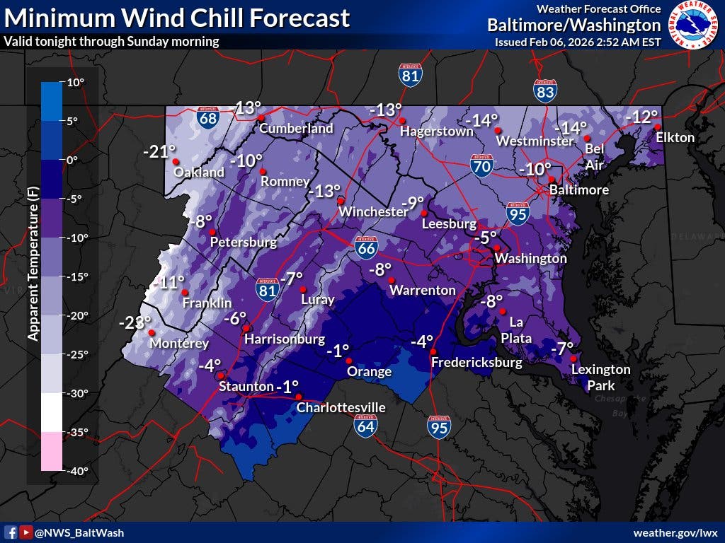
Dangerously cold wind chills as low as 10 to 15 degrees below zero are expected throughout the region, forecasters said. Wind chills will remain at or below zero during the day on Saturday due to windy conditions and cold temperatures.
"(The wind chills) could result in hypothermia if precautions are not taken," National Weather Service forecasters said. "Frostbite and hypothermia will occur if unprotected skin is exposed to these temperatures."
Widespread sub-freezing temperatures are expected to persist through early next week.
"The longevity of these sub-freezing temperatures will continue to increase the risk of impacts, including to people and infrastructure," according to the National Weather Service.
Here's a look at the latest detailed forecast for the D.C. region:
Friday: A chance of snow, mainly after 3pm. Mostly cloudy, with a high near 33. Light south wind. Chance of precipitation is 40%.
Friday Night: A chance of snow, mainly before 9pm. Cloudy during the early evening, then gradual clearing, with a low around 14. Blustery, with a light and variable wind becoming northwest 16 to 21 mph in the evening. Winds could gust as high as 36 mph. Chance of precipitation is 40%.
Saturday: Sunny, with a high near 19. Wind chill values as low as -6. Windy, with a northwest wind 29 to 32 mph, with gusts as high as 60 mph.
Saturday Night: Mostly clear, with a low around 11. Wind chill values as low as -6. Windy, with a northwest wind 23 to 28 mph decreasing to 17 to 22 mph after midnight. Winds could gust as high as 44 mph.
Sunday: Mostly sunny, with a high near 25. Northwest wind 14 to 16 mph, with gusts as high as 26 mph.
Sunday Night: Partly cloudy, with a low around 13.
Monday: Partly sunny, with a high near 32.
Monday Night: Mostly cloudy, with a low around 22.
Tuesday: Mostly sunny, with a high near 43.
Get more local news delivered straight to your inbox. Sign up for free Patch newsletters and alerts.