Weather
Flood, Severe Thunderstorm Watch Issued In VA: See Latest Forecast
A line of strong-to-severe thunderstorms could bring torrential rain to Northern Virginia on Thursday. See the latest forecast.


Strong to severe thunderstorms are expected to return to Northern Virginia on Thursday, bringing the potential for damaging wind gusts, torrential rainfall and localized flooding, forecasters said.
The National Weather Service issued a flood watch for the greater D.C. region, which is in effect from 2 p.m. Thursday until later this evening. A severe thunderstorm watch has also been issued for parts of Northern Virginia until 10 p.m.
According to forecasters, a cluster of strong-to-severe thunderstorms is likely to move across the region starting around 2 p.m. and continuing through the evening
Find out what's happening in Old Town Alexandriafor free with the latest updates from Patch.
The system is expected to bring very heavy rainfall to the area, bringing the chance for scattered gusts of up to 70 mph, lightning, and isolated hail the size of a quarter.
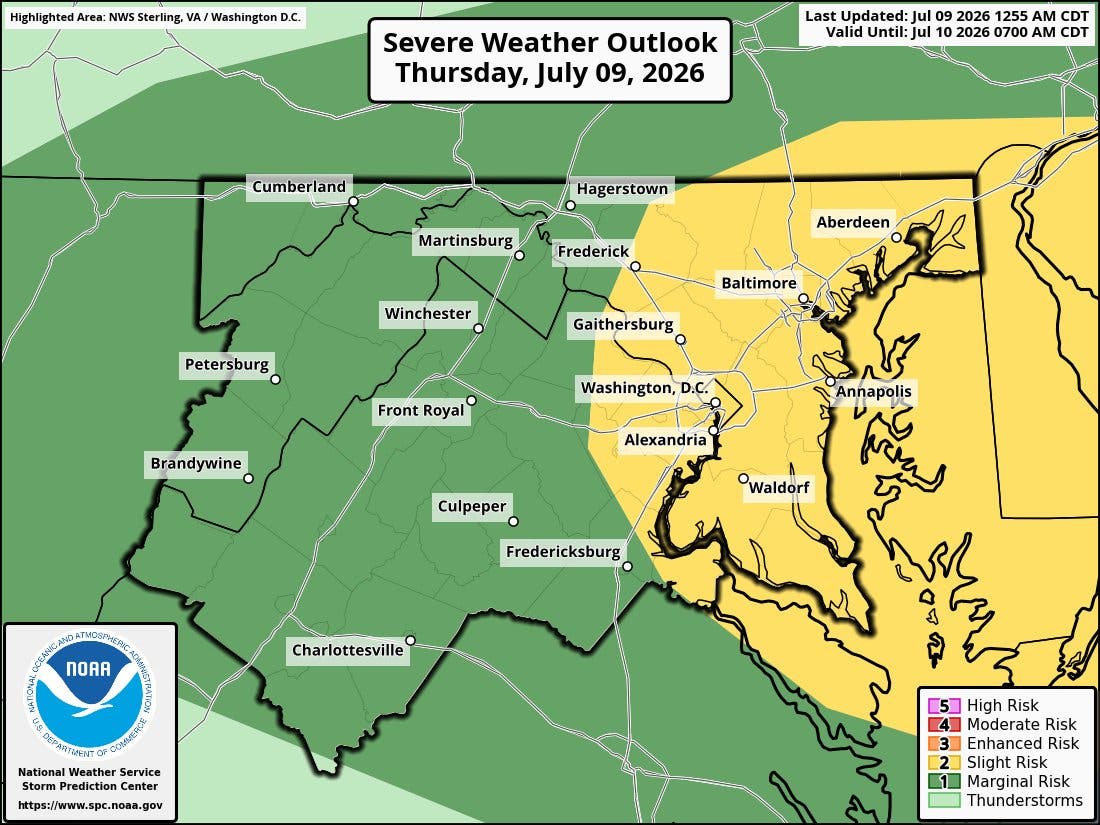
"These rates could approach 2 to 3 inches per hour, with higher instantaneous rates possible," the National Weather Service wrote. "The most vulnerable locations would be urbanized areas along I-95, as well as areas that have experienced heavy rainfall in recent days."
Find out what's happening in Old Town Alexandriafor free with the latest updates from Patch.
The primary threat of severe thunderstorms ends by
the mid-evening hours as the system pushes out of the state; however, scattered showers and thunderstorms are possible on Friday, mainly after 4 p.m.
Some lingering showers are possible over the weekend, when temperatures are expected to drop.
"The true drop in humidity levels does not take place until late
in the weekend into Monday. This should offer a dry start to the upcoming work week," the National Weather Service wrote. "Eventually, above-average temperatures return to the picture toward the middle of next week."
Detailed Northern Virginia Forecast
Thursday: Isolated showers, then showers and possibly a thunderstorm after 2pm. Some of the storms could produce heavy rainfall. High near 87. South wind 3 to 6 mph. Chance of precipitation is 90%. New rainfall amounts between a quarter and half of an inch possible.
Thursday Night: Showers and possibly a thunderstorm before 8pm, then isolated showers and thunderstorms between 8pm and 9pm. Some of the storms could produce heavy rainfall. Low around 70. Calm wind. Chance of precipitation is 80%. New precipitation amounts between a tenth and quarter of an inch, except higher amounts possible in thunderstorms.
Friday: Showers likely and possibly a thunderstorm before 4pm, then scattered showers and thunderstorms between 4pm and 5pm, then showers likely and possibly a thunderstorm after 5pm. Increasing clouds, with a high near 89. West wind 3 to 7 mph. Chance of precipitation is 60%. New rainfall amounts of less than a tenth of an inch, except higher amounts possible in thunderstorms.
Friday Night: Scattered showers and thunderstorms. Mostly cloudy, with a low around 69. Light west wind. Chance of precipitation is 30%.
Saturday: A chance of showers, then showers likely and possibly a thunderstorm after 2pm. Partly sunny, with a high near 84. Northwest wind 5 to 7 mph. Chance of precipitation is 60%.
Saturday Night: Showers and thunderstorms likely before 11pm, then a slight chance of showers between 11pm and 2am. Mostly cloudy, with a low around 65. Chance of precipitation is 60%.
Sunday: A slight chance of showers after 2pm. Mostly sunny, with a high near 84. Chance of precipitation is 20%.
Sunday Night: Partly cloudy, with a low around 64.
Monday: Mostly sunny, with a high near 84.
Get more local news delivered straight to your inbox. Sign up for free Patch newsletters and alerts.