Weather
Ian Remnants To Bring Rain, Other Impacts To Virginia: Full Forecast
As Ian moves up the coast, forecasters expect rain in Virginia from the remnants, and southeast coastal areas have a storm surge watch.

VIRGINIA — After Tropical Storm Ian made landfall as a category 4 hurricane Tuesday afternoon near Fort Myers, Florida, remnants may send rain and wind to Virginia. Some coastal areas of Virginia are under a storm surge watch.
Millions of Floridians were ordered to evacuate their homes, and over 2.6 million people are without power after the hurricane made landfall. The hurricane caused damage with up to 155 mph sustained winds, storm surge and heavy rain.
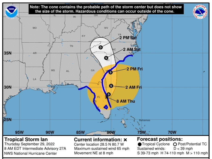
By Thursday morning, Ian was a tropical storm with 70 mph winds and was moving to the east coast at 8 mph. The National Hurricane Center expects Ian to re-intensify and be near hurricane strength when it approaches the South Carolina coast Friday. A second landfall is expected as a tropical storm near the South Carolina/Georgia border. Ian is expected to weaken as it moves inland across the Carolinas Friday night and Saturday.
Find out what's happening in Old Town Alexandriafor free with the latest updates from Patch.
In Virginia, Gov. Glenn Youngkin declared a state of emergency Wednesday evening to prepare for the arrival of the remnants of Hurricane Ian in Virginia. The storm is expected to be a tropical depression by the time it reaches Virginia, with impacts starting Friday.
RELATED: VA State Of Emergency Declared Ahead Of Hurricane Ian
Find out what's happening in Old Town Alexandriafor free with the latest updates from Patch.
The National Weather Service's Baltimore-Washington office expects rain associated with Ian remnants to start affecting the greater DC area by late Friday through the weekend. Remnants are expected to leave offshore by early next week.
Stay up-to-date by viewing all Hurricane Ian coverage on Florida Patch sites here.
Forecasters believe most of the area will see times of moderate to heavy rain, but models largely suggest relatively dry forecasts for southern Maryland and points south to southeastern Virginia.
"Overall, the pattern looks to be more of a beneficial rainfall at this time, but some scattered instances of flooding may be possible, especially Saturday into Sunday for areas along and
west of the Blue Ridge Mountains and south of US-50," the National Weather Service stated in its forecast.
Accuweather is predicting at least 2 to 4 inches of rain in much of Virginia.
"Ian will slow down over the Southeast states, but as long as it maintains some forward speed, rainfall will be heavy but not over the top," said Alex Sosnowski, an AccuWeather senior meteorologist. "However, if Ian stalls over the Southeast for a day or two, there is the potential for much heavier rainfall to fall over a broad area, including interior locations."
The National Weather Service's Wakefield office issued a storm surge watch and coastal flood watch for coastal parts of southeastern Virginia. The storm surge watch means "life-threatening inundation, from rising water moving inland from the coastline" is possible within 48 hours. A coastal flood watch means low-lying areas near shorelines and tidal waterways would see two feet of inundation above ground level. A tropical storm warning is impacting areas south of Virginia in North Carolina.
National Weather Service forecasters believe the main wind threat in the DC region will be marine winds. A "non-zero chance" of winds from Ian are possible in some areas, particularly higher elevations and west of the Blue Ridge mountains.
All available Virginia State Police personnel are on standby during the storm, and its search and rescue divers are pre-deploying to based on projected rainfall, vulnerable flood zones and storm surge.
State police urged Virginia drivers to follow these tips during the storm:
- Headlights are required to be on when windshield wipers are activated. Headlights both help you see and be seen.
- Slow your speed for conditions.
- Everyone in the vehicle should wear a seat belt.
- Put the phone down and limit other distractions.
- If you encounter standing water in the road, turn around, don't drown. The depth of the water can be deceiving and dangerous for all vehicles.
- Turn to VDOT's 511 for the latest in road closures and openings. Please do not call 911 or #77 for non-emergency issues or road closure information.
Here's the latest forecast for the Northern Virginia region:
- Thursday: Partly sunny with a high near 69 and mostly cloudy at night with a low around 52. Northeast wind around 14 mph and gusts as high as 24 mph. At night, wind will be around 9 mph with gusts up to 20 mph.
- Friday: A chance of rain after 2 p.m. and mostly cloudy with a high near 66. Winds will be between 10 to 14 mph with gusts as high as 25 mph. At night, rain is likely, mainly after 2 a.m. Otherwise, cloudy with a low around 55, winds between 14 to 16 mph and gusts as high as 31 mph.
- Saturday: Rain is likely. Cloudy, with a high near 62 and winds between 15 to 17 mph with gusts up to 32 mph. At night, rain is likely, along with clouds and a low of 55.
- Sunday: Showers are likely, and mostly cloudy with a high near 62. At night, showers likely and mostly cloudy with a low around 51.
- Monday: Rain transitions to scattered showers and partly sunny with a high near 61. At night, scattered showers and cloudy conditions with a low around 49.
Get more local news delivered straight to your inbox. Sign up for free Patch newsletters and alerts.