Weather
Multiple Rounds Of Storms In VA Forecast: See Latest Timeline
Damaging winds, large hail and flash flooding are possible Thursday when a cold front pushes into Northern Virginia. See the forecast.


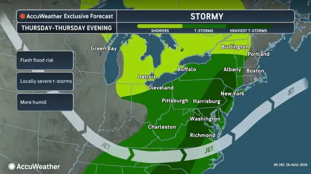
The threat of severe thunderstorms is increasing across Northern Virginia on Thursday, when storms could bring damaging winds, large hail and isolated flash flooding, according to the National Weather Service.
Forecasters expect a warmer, increasingly humid air mass to settle over the region ahead of an approaching cold front. While a stray shower is possible Wednesday afternoon, no hazardous weather is expected through Wednesday night.
What To Expect Thursday
The first chance for more widespread storms arrives overnight into Thursday morning, when scattered showers and thunderstorms could develop. The National Weather Service said how much morning rain and cloud cover develops could influence the severity of storms later in the day.
Find out what's happening in Old Town Alexandriafor free with the latest updates from Patch.
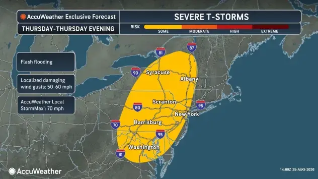
The main severe weather window is expected between 1 and 9 p.m. Thursday, with scattered severe storms possible. Damaging wind gusts are the primary threat, although storms could also produce large hail and isolated flash flooding.
Forecasters said there could be two rounds of storms — one during the early afternoon and another later in the evening. If conditions become favorable enough, one or two supercells could develop, and the National Weather Service said a tornado cannot be ruled out.
Find out what's happening in Old Town Alexandriafor free with the latest updates from Patch.
What Comes Next
Some showers and thunderstorms could linger Friday, but the threat of severe weather will be lower. A few showers or storms remain possible into the early weekend before progressively drier weather takes hold.
Another shift arrives early next week, when summer heat and humidity return.
The National Weather Service expects highs in the low to mid-90s Monday through Wednesday, with heat index values generally between 95 and 100 degrees. In a hotter scenario, heat indices could reach 105 degrees. Thunderstorm chances may also increase again as the week progresses.
Detailed Northern Virginia Forecast
Wednesday Afternoon: Partly sunny, with a high near 87. South wind 6 to 9 mph.
Wednesday Night: Mostly cloudy, with a low around 69. Southeast wind around 8 mph.
Thursday: A chance of showers and thunderstorms, mainly after 2pm. Partly sunny, with a high near 89. South wind 7 to 10 mph. Chance of precipitation is 30%.
Thursday Night: Showers likely and possibly a thunderstorm before 8pm, then a chance of showers and thunderstorms between 8pm and 2am. Some of the storms could be severe. Mostly cloudy, with a low around 67. South wind around 6 mph becoming calm in the evening. Chance of precipitation is 60%. New rainfall amounts between a quarter and half of an inch possible.
Friday: A slight chance of showers and thunderstorms after 2pm. Partly sunny, with a high near 86. Calm wind becoming north around 5 mph in the afternoon. Chance of precipitation is 20%.
Friday Night: A slight chance of showers and thunderstorms before 8pm, then a slight chance of showers between 8pm and 2am. Mostly cloudy, with a low around 66. Chance of precipitation is 20%.
Saturday: Partly sunny, with a high near 86.
Saturday Night: Partly cloudy, with a low around 67.
Sunday: Mostly sunny, with a high near 88.
Get more local news delivered straight to your inbox. Sign up for free Patch newsletters and alerts.