Weather
Nor'easter Impacts In VA: Here's What We Can Expect From This Storm
Find out the latest storm track, its impacts on Virginia and what it means for your weekend, according to meteorologists.

A rapidly intensifying coastal storm isn't likely to bring any significant snowfall to Northern Virginia this weekend; however, it could disrupt some travel plans as bitterly cold temperatures continue to maintain a tight grip on the D.C. region.
This weekend's storm is expected to take shape on Friday, then evolve into a nor'easter along the Atlantic Coast into Saturday, according to forecasters
The most significant snowfall is predicted for the Carolinas, the southern Appalachians and parts of southern Virginia, where a winter storm warning is in effect from 4 a.m. Saturday until 7 p.m. Sunday. Total snow accumulations between 5 and 10 inches are expected.
Find out what's happening in Old Town Alexandriafor free with the latest updates from Patch.
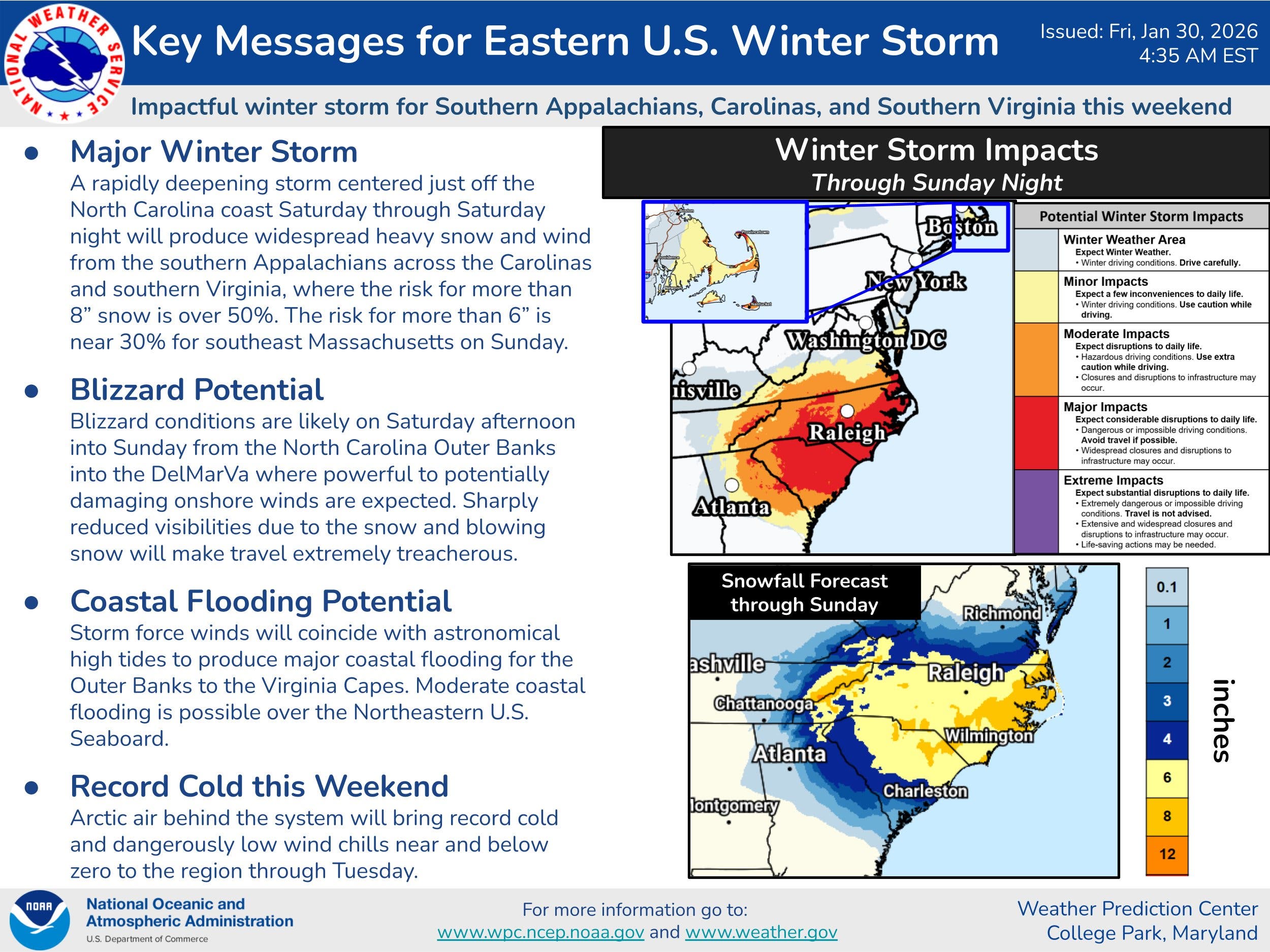
Right now, the storm will likely stay to the south and east of the D.C. region, which will probably see a dusting of snow at most on Saturday, according to The Washington Post's Capital Weather Gang.
The storm is also expected to bring strong winds to Virginia on Saturday and Sunday, with gusts reaching up to 40 mph at times on Sunday.
Find out what's happening in Old Town Alexandriafor free with the latest updates from Patch.
Virginians with weekend travel plans should keep an eye on the forecast and expect major disruptions in the southern portion of the state, according to NBC Washington meteorologists.
"I-95 and I-85 from southern Virginia to South Carolina, I-81 in southwest Virginia and east Tennessee and I-40 from eastern North Carolina to Nashville will all be snow-covered," NBC Washington forecasters said. "Airports from Charlotte Douglas to Raleigh to Greenville-Spartanburg to Asheville to Norfolk will all have widespread cancellations and delays."
.jpg)
Meanwhile, bitterly cold temperatures and dangerous wind chills are expected to linger through the weekend as an Arctic blast of air sweeps in behind the storm, forecasters said.
A cold weather advisory is in effect for the D.C. region until 10 a.m. Saturday, the National Weather Service said. Very cold wind chills as low as 10 degrees below zero are expected, which could result in hypothermia if precautions are not taken.
By Monday, temperatures could finally climb above freezing with highs aiming for the mid-30s.
Here's a look at the detailed National Weather Service forecast for the region:
Friday: Partly sunny, with a high near 21. Northwest wind 6 to 8 mph.
Friday Night: Mostly cloudy, with a low around 9. Wind chill values as low as -3. North wind around 7 mph.
Saturday: Mostly cloudy, with a high near 22. Wind chill values as low as -4. North wind 9 to 13 mph, with gusts as high as 21 mph.
Saturday Night: A slight chance of snow before 1am. Mostly cloudy, with a low around 12. Wind chill values as low as -4. Blustery, with a north wind 15 to 20 mph, with gusts as high as 38 mph. Chance of precipitation is 20%.
Sunday: Mostly sunny, with a high near 26. Blustery, with a northwest wind 18 to 22 mph, with gusts as high as 45 mph.
Sunday Night: Mostly clear, with a low around 17.
Monday: Sunny, with a high near 32.
Monday Night: Partly cloudy, with a low around 19.
Tuesday: Mostly sunny, with a high near 36.
Get more local news delivered straight to your inbox. Sign up for free Patch newsletters and alerts.