Weather
Potentially Severe Thunderstorms In NoVA Weekend Forecast: What To Know
The storms could break a several-day heat wave when temperatures are expected to soar into the 90s.

Thunderstorms could slam into Northern Virginia later this weekend, bringing potentially damaging wind gusts and interrupting weekend plans.
The National Weather Service said the storms could be "strong to severe."
The storms will follow a period of brutal heat, with temperatures expected to exceed 90 degrees for three straight days starting Friday.
Find out what's happening in Old Town Alexandriafor free with the latest updates from Patch.
"Compared to the final weekend of May, temperatures this weekend will be 20-25 degrees higher across much of the region," Accuweather said. "The contrast will be even greater compared to Memorial Day weekend, when daytime highs in many areas challenged record-cold maximum temperatures. This weekend is projected to be 35-40 degrees warmer across portions of the Northeast."
A Code Orange air quality alert is also in effect for the Northern Virginia on Friday, meaning that air pollution concentrations in the area may become unhealthy for some people, including children, the elderly, or those suffering from asthma, heart disease, or other lung diseases.
Find out what's happening in Old Town Alexandriafor free with the latest updates from Patch.
Meanwhile, chances of storms begin late Saturday as a cold front moves into the state.
Strong to severe thunderstorms are possible across the northern portions of the D.C.-Baltimore forecast area on Saturday afternoon and into the evening, according to the National Weather Service.
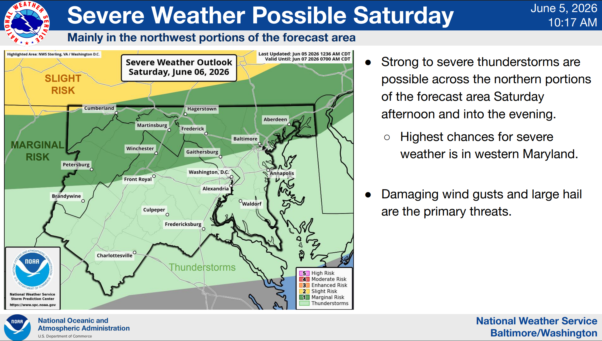
The highest chances for severe weather are in western Maryland. Damaging wind gusts and large hail will likely be the primary threats.
As the cold front passes through the forecast area, strong to severe thunderstorms remain possible on Sunday. The highest chances for severe weather are in the southern portions of the
forecast area, mainly along and east of the Blue Ridge.
On the back end of the cold front, temperatures will offer a brief respite from the heat with highs expected to reach the mid-80s on Monday and Tuesday.
By Wednesday, temperatures will likely climb back into the 90s. Hot and humid conditions will also bring daily shower and thunderstorm chances beginning midweek.
Here is the detailed weather forecast for Northern Virginia:
Friday: Mostly sunny, with a high near 92. West wind 3 to 5 mph.
Friday Night: Partly cloudy, with a low around 64. Light southwest wind.
Saturday: Mostly cloudy, then becoming sunny during the afternoon, with a high near 94. Light west wind increasing to 6 to 11 mph in the morning. Winds could gust as high as 21 mph.
Saturday Night: A chance of showers and thunderstorms. Partly cloudy, with a low around 68. West wind 5 to 7 mph. Chance of precipitation is 30%.
Sunday: Mostly sunny, with a high near 90. Northwest wind 7 to 10 mph, with gusts as high as 18 mph.
Sunday Night: Mostly clear, with a low around 65.
Monday: Sunny, with a high near 86.
Monday Night: Mostly clear, with a low around 60.
Tuesday: Mostly sunny, with a high near 86.
Get more local news delivered straight to your inbox. Sign up for free Patch newsletters and alerts.