Weather
Snow Returns To NoVA: Timing, How Much Accumulation To Expect
Rain, wind and snow are in the forecast for Northern Virginia. Here are the latest details and timeline.

Rain falling across Northern Virginia could turn to snow on Thursday as colder air moves in, bringing gusty winds and dramatically cooler temperatures to the D.C. region through the day.
A hazardous weather outlook is in effect for Northern Virginia and the tidal Potomac River as a massive cold front moves through the state.
According to the National Weather Service, rain falling in Northern Virginia could precede a brief period of snow on Thursday. If any accumulation occurs, it will likely be on grassy surfaces.
Find out what's happening in Old Town Alexandriafor free with the latest updates from Patch.
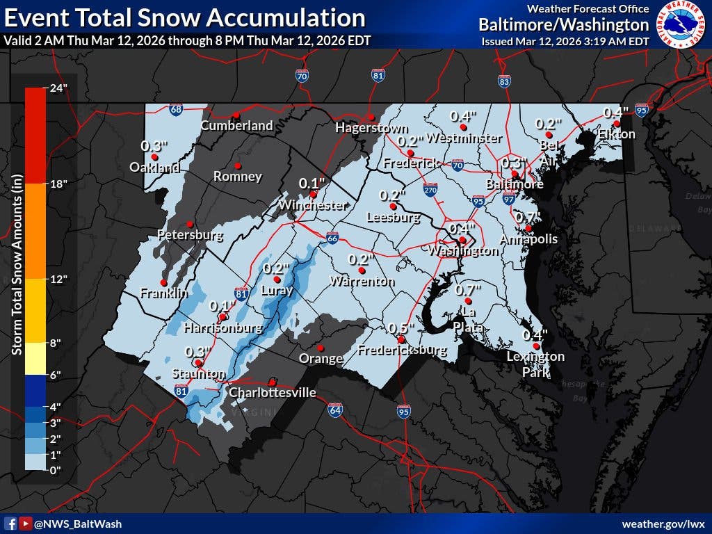
In the southern parts of the region, snow may be heavier and could cause some slush on roads.
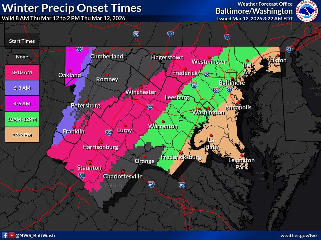
As for timing, The Washington Post's Capital Weather Gang wrote that rain on Thursday morning may mix with or turn to snow before ending in the early afternoon.
Find out what's happening in Old Town Alexandriafor free with the latest updates from Patch.
"With temperatures above freezing, there’s not much concern about iciness," Capital Weather Gang forecasters wrote.
After reaching more than 80 degrees on Wednesday, cold temperatures will make a chilly comeback through Thursday. Highs are expected to be in the 40s, but could slip into the 30s.
Strong, blustery winds are also expected on Thursday, averaging around 15 mph with gusts approaching 30 mph.
Winds prompted National Weather Service forecasters to issue several alerts for Maryland waters, including a small craft advisory for the tidal Potomac River from Key Bridge to Smith Point, and the Chesapeake Bay and adjoining estuaries north of Smith Point.
"A brief period of gusts near gale force is possible this morning," forecasters wrote. "Inexperienced mariners, especially those operating smaller vessels, should avoid navigating in hazardous conditions."
Looking ahead, the D.C. region should see temperatures in the mid- to upper 50s on Saturday and then 50s to low 60s on Sunday.
Temperatures will fall again early next week, ushering in a return to more winter-like conditions.
Here's a look at the detailed National Weather Service forecast for the D.C. region:
Thursday: Rain before 1pm, then rain and snow. High near 55. Breezy, with a northwest wind 15 to 20 mph, with gusts as high as 34 mph. Chance of precipitation is 100%. Total daytime snow accumulation of less than a half inch possible.
Thursday Night: Mostly clear, with a low around 32. Northwest wind 6 to 11 mph becoming light and variable. Winds could gust as high as 21 mph.
Friday: Mostly sunny, with a high near 53. Breezy, with a south wind 5 to 10 mph increasing to 16 to 21 mph in the afternoon. Winds could gust as high as 38 mph.
Friday Night: Mostly clear, with a low around 43. Southwest wind 11 to 14 mph, with gusts as high as 29 mph.
Saturday: Partly sunny, with a high near 58. West wind around 11 mph.
Saturday Night: Mostly cloudy, with a low around 43.
Sunday: Mostly cloudy, with a high near 61.
Sunday Night: Showers likely, mainly after 2am. Mostly cloudy, with a low around 55. Chance of precipitation is 70%.
Monday: Showers. High near 68. Windy. Chance of precipitation is 90%.
Monday Night: A chance of showers before 2am. Mostly cloudy, with a low around 33. Breezy. Chance of precipitation is 40%.
Tuesday: Mostly sunny, with a high near 42.
Get more local news delivered straight to your inbox. Sign up for free Patch newsletters and alerts.