Weather
Threat Of Major Winter Storm Increases For VA: Latest Forecast
The huge weather event affecting much of the country is gaining strength and seems more likely to drop 6 inches or more of snow in Virginia.

Weather forecasters say the odds are increasing that a major snowstorm will strike Virginia this weekend, with one forecast noting it could be the biggest winter storm to hit the Commonwealth in 10 years.
That comes as the storm draws nearer and forecasters begin to gain a clearer picture of what looks to be the most significant weather of the winter thus far.
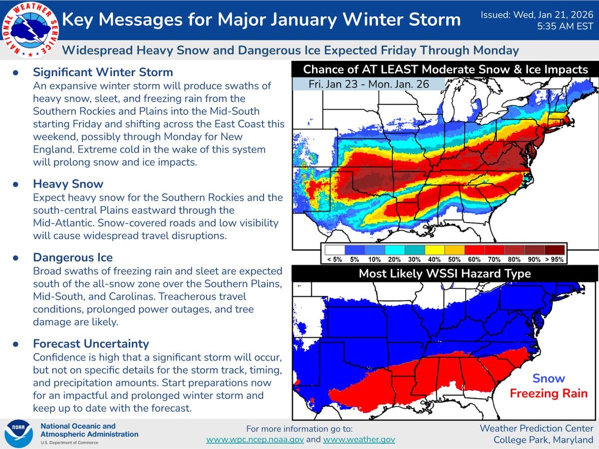
Forecasters with the National Weather Service Weather Prediction Center said Wednesday morning that the path of the storm has shifted to the north, which bumps up likely snowfall totals for Virginia and the rest of the Mid-Atlantic region.
Find out what's happening in Old Town Alexandriafor free with the latest updates from Patch.
Heavy snow and low visibility will cause widespread travel disruptions Sunday and Monday. The NWS urged residents to start preparing now for a prolonged winter storm, along with school and business closures, road closures, flight delays or cancellations, and general disruptions to infrastructure.
Before the storm arrives, Northern Virginians are in for at least three mild days with high temperatures reaching 40 on Wednesday and Friday, and hitting 51 degrees on Thursday.
Find out what's happening in Old Town Alexandriafor free with the latest updates from Patch.
Snowfall is likely to begin after 1 p.m. Saturday, ramp up overnight and continue through Sunday night.
"The odds of a major winter storm this weekend continue to climb," said the weather team at NBC Washington. "Thursday will be a good day to shop for snow supplies as temperatures will be a little milder in the 50s. … This upcoming storm will come on the 10-year anniversary of the blizzard of 2016 and may well end up being our biggest snowfall since that infamous storm. Take full advantage of the next few days to get storm ready."
The Washington Post's Capital Weather Gang has upped the likelihood of impactful snow and ice in the Baltimore-DC region over the weekend, along with brutal cold.
"While not a lock, the odds of accumulating snow between late Saturday and early Monday continue to rise," the Post said. "There is certainly big snow potential — several inches or more, maybe mixed with ice — but it’s still a little too early to talk numbers."
More than 6 inches of snow is possible according to Accuweather, which is forecasting up to 12 inches in many parts of the mid-Atlantic.
The storm will have heavy impacts on large regions of the country, Accuweather says.
"Potentially hundreds of thousands of people may go without electricity and heat for days,” Accuweather Chief Meteorologist Jonathan Porter said.
The high temperature Saturday, when the storm first arrives, will only be 20 degrees. Lows will be in the mid teens on both Saturday and Sunday night, and will drop to 7 on Monday, meaning that everything will freeze. Ice may compound whatever issues are caused by snow.
"In areas where a thick glaze of ice forms, scores of trees and power lines may come down, and removing ice from streets, highways, parking lots and sidewalks may be difficult or impossible, especially where ice-melting supplies are limited," Accuweather adds. "Utility crews could be overwhelmed by the scope of the storm."
Here's the full forecast, according to the National Weather Service:
Wednesday
Mostly sunny, with a high near 40. South wind 9 to 14 mph, with gusts as high as 25 mph.
Wednesday Night
Mostly cloudy, then gradually becoming mostly clear, with a low around 33. Southwest wind around 10 mph, with gusts as high as 18 mph.
Thursday
Mostly sunny, with a high near 51. West wind 8 to 11 mph, with gusts as high as 22 mph.
Thursday Night
Partly cloudy, with a low around 29. Northwest wind around 6 mph becoming calm in the evening.
Friday
Mostly cloudy, with a high near 40. Light northwest wind becoming west 5 to 10 mph in the morning. Winds could gust as high as 18 mph.
Friday Night
Mostly cloudy, with a low around 11.
Saturday
A chance of snow after 1pm. Mostly cloudy, with a high near 20. Chance of precipitation is 30%.
Saturday Night
Snow. Low around 14. Chance of precipitation is 80%.
Sunday
Snow. High near 20. Chance of precipitation is 90%.
Sunday Night
A chance of snow. Mostly cloudy, with a low around 14. Chance of precipitation is 50%.
Monday
Mostly sunny, with a high near 26.
Monday Night
Mostly clear, with a low around 7.
Tuesday
Sunny, with a high near 26.
Get more local news delivered straight to your inbox. Sign up for free Patch newsletters and alerts.