Weather
VA, DC Weather: 70 MPH Winds Possible, Severe Thunderstorm Watch
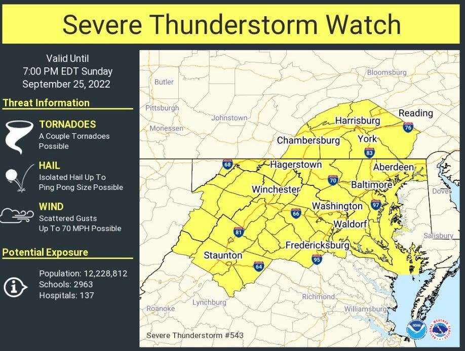
Parts of Northern Virginia are under a severe thunderstorm watch, with large hail and 70 mph winds possible, forecasters said.

BALTIMORE, MD —Parts of Northern and central Virginia are under a severe thunderstorm watch, with large hail and 70 mph winds possible until 7 p.m. Sunday, the National Weather Service said.
Showers and thunderstorms will expand across the region Sunday afternoon. Some storms may produce damaging winds and large hail. Ping pong ball size hail has already been reported in western Maryland, the NWS said.
Counties in the watch include: Arlington, Fairfax, Fauquier, Loudoun, Prince William, Spotsylvania, Stafford and Warren.
Find out what's happening in Old Town Alexandriafor free with the latest updates from Patch.
Cities in the watch area are: Alexandria, Charlottesville, Fairfax, Falls Church, Fredericksburg, Harrisonburg, Manassas, Manassas Park, Staunton, Waynesboro and Winchester.
The weather service has also issued a hazardous weather outlook for the Baltimore-Washington, D.C., region. The outlook covers much of the Chesapeake Bay from north of Pooles Island, Maryland, to Smith Point, Virginia along with the tidal Potomac River from Key Bridge in Maryland to Smith Point. The Patapsco River including Baltimore Harbor is also included.
Find out what's happening in Old Town Alexandriafor free with the latest updates from Patch.
This hazardous weather outlook is for the Maryland portion of the Chesapeake Bay, tidal Potomac River, and I-95 corridor through central Maryland, northern Virginia, and District of Columbia.
A severe thunderstorm is possible late this afternoon; thunderstorms can bring damaging winds and even an isolated tornado, AccuWeather.com said.
Here's the latest forecast from the National Weather Service:
Sunday Afternoon: Scattered showers and thunderstorms, then showers likely and possibly a thunderstorm after 3pm. Some storms could be severe, with large hail and damaging winds. Mostly cloudy, with a high near 79. Southwest wind 11 to 13 mph, with gusts as high as 23 mph. Chance of precipitation is 70%. New rainfall amounts between a tenth and quarter of an inch, except higher amounts possible in thunderstorms.
Sunday Night: Showers and thunderstorms likely, mainly before 10pm. Some of the storms could be severe. Cloudy during the early evening, then gradual clearing, with a low around 58. West wind around 8 mph. Chance of precipitation is 60%. New precipitation amounts of less than a tenth of an inch, except higher amounts possible in thunderstorms.
Monday: Sunny, with a high near 77. West wind 7 to 13 mph, with gusts as high as 23 mph.
Monday Night: Mostly clear, with a low around 54. West wind around 7 mph.
Get more local news delivered straight to your inbox. Sign up for free Patch newsletters and alerts.