Weather
Wednesday Will Be The Windiest Day In A Stormy Week Ahead
Several storms are on tap in the days to come, but the worst of the winds should pass by Wednesday evening.

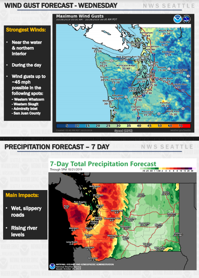
SEATTLE, WA — Amid a wet and windy week ahead, meteorologists expect Wednesday will bring our region the highest winds. Tuesday night brought the first system in, with several others headed to Western Washington through the weekend. Beginning in the early hours Wednesday, rain showers and a breeze will give way to steady precipitation and wind gusts ranging from 25 to 45 mph by the afternoon. The morning commute will be a soaker.
Since many trees still have a fair amount of leaves on them, meteorologists say there is a good chance many places will see downed branches, clogged drains and isolted power outages. Forecasters do not expect flooding or widespread outages.
Get real-time updates (and a predictive map of where winds will be strongest) via City Light's WindWatch: https://t.co/fWbQ2AiMPf #WAWx pic.twitter.com/FRLyvxGNux
— Seattle City Light (@SEACityLight) October 16, 2019
Around Seattle, sustained winds may reach 20 mph and some gusts could hit 35 mph. In the Tacoma area, winds will range from 15 to 25 mph with a potential for gusts at 30 mph. Winds will be strongest along the coast and the northern interior. A Wind Advisory is in place for Whatcom, Skagit and San Juan Counties. Wet weather patterns will carry on into next week, but the winds should slow down after Wednesday. NWS meteorologists will continue to provide an updated outlook as the week continues.
Find out what's happening in Across Washingtonfor free with the latest updates from Patch.
Get more local news delivered straight to your inbox. Sign up for free Patch newsletters and alerts.