Weather
Wet Weather Into Thursday, Lowland Snow Less Likely
Thursday will bring sun breaks for many of us, with a few rain showers and a brief chance at lowland snow in some areas.

SEATTLE, WA — Wet weather is in the forecast through at least Thursday morning in Western Washington, but slightly higher temperatures and strong winds from the east are likely to limit snowfall between the I-5 corridor and the Cascade foothills. Snow levels were expected between 500 and 1,500 feet, and there is a chance for a rain-snow mix in some areas, and snowfall in the hilltop locations.
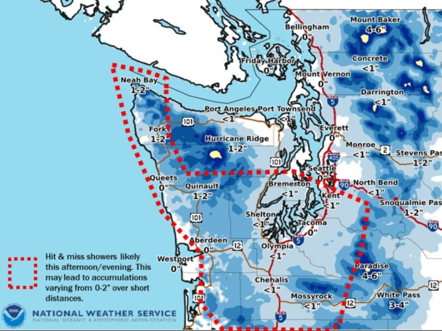
FORECAST UPDATE *Most lowland locations should not expect any snowfall accumulation. In fact, there will be off and on sun breaks through the day *However, hit & miss showers could see temporarily lowered snow levels and brief accumulations. See map for details.#wawx pic.twitter.com/V8DJn0J4HR
— NWS Seattle (@NWSSeattle) January 16, 2020
WEATHER HEADLINES
- Strongest winds through Wednesday night along the west slopes of the Cascades, the foothills and the east Puget Sound lowlands.
- Heaviest snow over the Kitsap Peninsula, Hood Canal, and the Olympics, including Clallam County.
- Temperatures near freezing overnight, then rising to the upper 30s in the lowlands during Thursday.
- Winds lighten up by Thursday afternoon as precipitation becomes more spotty.
- New weather system Friday with more high winds and widespread precipitation.
High winds in the east Puget Sound lowlands have the potential to cause power outages and tree damage into the early morning hours. Thousands of outages had already been reported in Kirkland, Fall City and North Bend by Wednesday evening. More than 13,000 outages were reported throughout Snohomish County.
Find out what's happening in Across Washingtonfor free with the latest updates from Patch.
Gusts in Everett, Seattle and Tacoma were projected between 25 and 30 mph.
Report of power out with gusts to 50 mph in North Bend. The high wind warning remains in effect until 10 pm for the Puget Sound lowlands including North Bend and Enumclaw for sustained east to southeast winds 35 to 45 mph with gusts 55 to 60 mph. #wawx
— NWS Seattle (@NWSSeattle) January 16, 2020
POWER OUTAGE MAPS
Find out what's happening in Across Washingtonfor free with the latest updates from Patch.
Puget Sound Energy
Snohomish County PUD
NWS Seattle said precipitation will transition to scattered showers by Thursday afternoon, and a few dustings of snow in the lowlands are possible Thursday afternoon into Friday morning. Another wet weather system is now forecast for Friday night, with snow levels hovering around 500 feet. Temperatures are expected to climb this weekend.
UPDATE: I-90 remains closed in both directions from North Bend (MP 34) to Ellensburg (MP 106). Crews are working to clear the wrecks and an evaluation will be made at midnight. No estimated reopening time.
— I-90 Snoqualmie Pass (@SnoqualmiePass) January 16, 2020
@KING5Seattle @komonews somehow we still have power, but a massive tree fell on our neighbors house just now! pic.twitter.com/VuGM4W6zKX
— Sarah Eisenhauer (@tw1tterlessarah) January 16, 2020
Well #Everett is faring pretty well in the power outage situation so far but the rest of Snohomish County not so much. If you see a @SnoPUD crew out there, thank them. pic.twitter.com/fX84zWmDG4
— MyEverettNews.com (@MyEverettNews) January 16, 2020
There is 12,609 @PSETalk and 10,603 @SnoPUD customers without power and these are steadily increasing. Charge phones, have flashlights/batteries ready, check on neighbors if you can especially the ones that rely on electricity.#PowerOutages #BePrepared
— WA Crime Watch (@WACrimeWatch) January 16, 2020
Winter Storm Warnings & Winter Wx Advisories have ended for most of lowlands. Winter Storm Warning downgraded to Winter WX Advisory for Hood Canal area until 4AM THU. Snow at times above 500 ft; additional accumulations up to 3". Plan on slippery road conditions. #WAwx
— NWS Seattle (@NWSSeattle) January 16, 2020
Traffic light at SR204 and 91st is out. Slow down, treat it like a 4-way stop. Hopefully it will be fixed quickly. @wsdot_north #lakestevenspd pic.twitter.com/pn1Li3ETAf
— Lake Stevens Police (@LKS_POLICE) January 16, 2020
Signal Warning!! The winds are causing havoc with the signals & the signal at NE Park Dr & 10th Ave NE has wrapped itself around, it's twisted. The signal still works, but Public Works is unable to put someone up in a boom truck with the wind until it slows. Please use CAUTION! pic.twitter.com/9DzB4bi3cc
— Issaquah Police (@IssaquahPolice) January 16, 2020
**SAFETY ALERT** A tree branch brought down some wires on the 14000 block of NE 72nd Place and the road is currently closed. Please avoid the area. Keep in mind to stay away from any live wires that come down and call 911 to report. pic.twitter.com/HZtuRuzMCy
— RedmondWaPD (@RedmondWaPD) January 16, 2020
Get more local news delivered straight to your inbox. Sign up for free Patch newsletters and alerts.