Weather
Puget Sound Forecast: Calmer Wednesday, With More Soakers Ahead
After a wild and windy Tuesday, Puget Sound looks to have earned itself a short break. But the next atmospheric river won't be far behind.

SEATTLE — Wednesday's weather should be relatively peaceful compared to Tuesday's wet and wind-fueled storms, but any reprieve from the rain won't last long, according to the latest forecasts.
Weather alerts sprouted up across the region Tuesday, including a brief tornado warning in Kitsap County, as powerful wind gusts swept across Western Washington. The high winds also took down power poles and trees, causing several headaches on the roads and power outages affecting thousands of households.
Some pictures from Madison Street just west of Lake Washington Boulevard in Seattle right after the heavy showers moved through earlier this afternoon. Pictures courtesy of a retired NWS Seattle lead forecaster. Stay aware out there today! #wawx pic.twitter.com/X3FATW8APd
— NWS Seattle (@NWSSeattle) November 9, 2021
Fortunately, the strongest gusts have eased, and forecasters say Wednesday looks considerably calmer, though a light breeze will stick around. Puget Sound should still see some moisture, but the National Weather Service expects showers will let up for at least part of the day, allowing a short window to dry off before the next front arrives. Then, on Thursday night, another atmospheric river winds its way into town.
Find out what's happening in Seattlefor free with the latest updates from Patch.
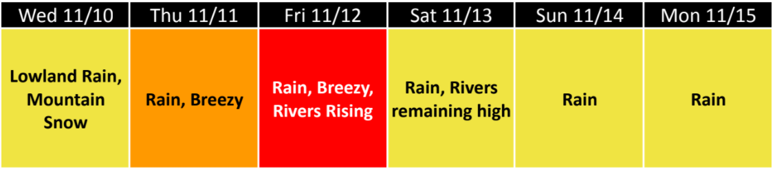
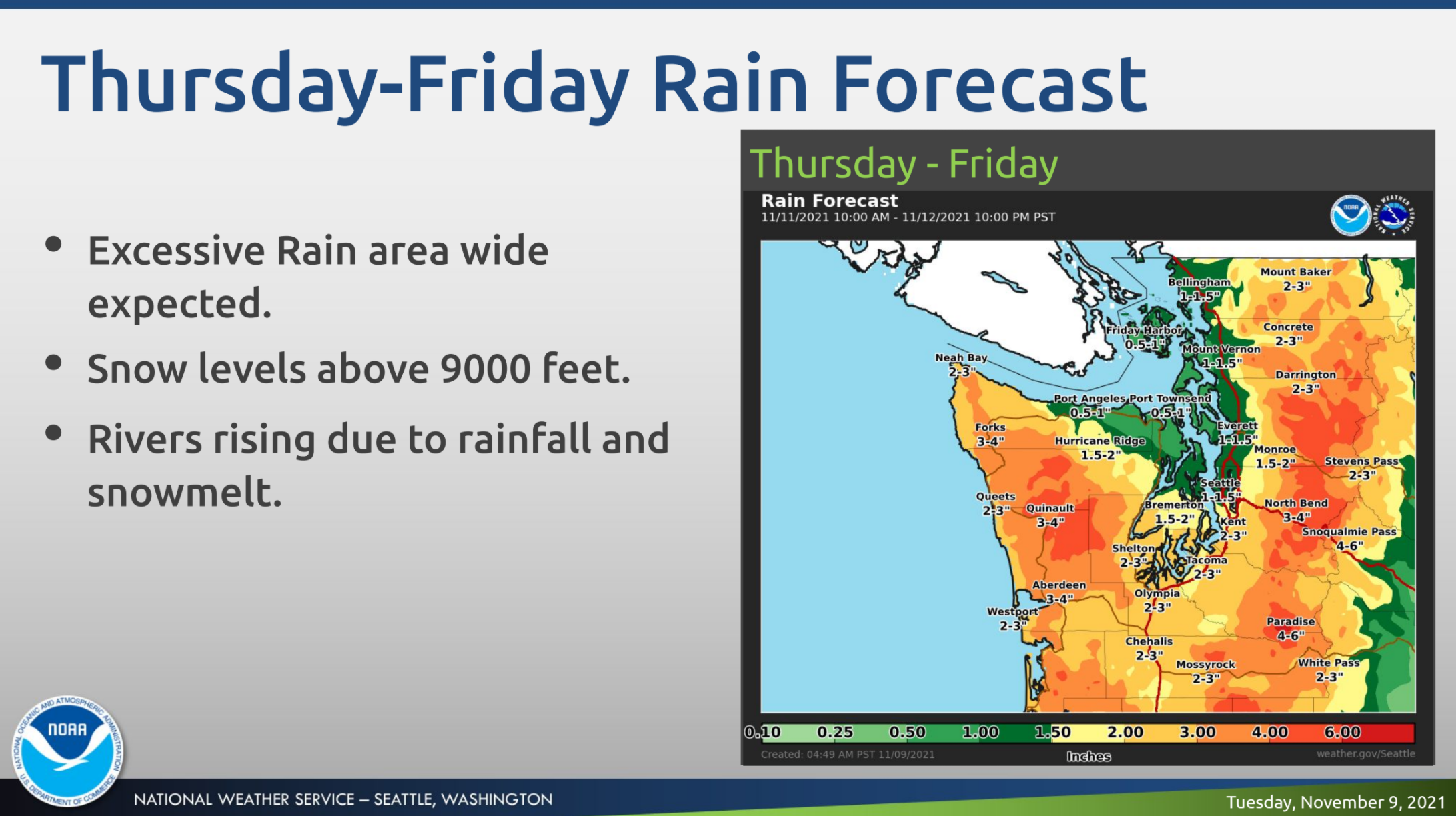
"Scattered showers Wednesday morning ought to end by afternoon for a brief break in the weather," NWS Seattle wrote Tuesday. "A warm front will arrive Wednesday night and Thursday, followed by an atmospheric river weather pattern Thursday night and Friday — a strong, moist, and rather warm plume of moisture will be directed into Western Washington for a period of heavy rain — especially in the mountains."
Forecasters are confident the late-week storm will bring periods of excessive rain across the region, and area rivers are likely to rise and run high through Saturday.
Find out what's happening in Seattlefor free with the latest updates from Patch.
The National Weather Service said another well-earned break in the weather could materialize Saturday before the next storms roll in.
"The heavy rain will taper off Friday night and Saturday looks like a break in the rain," NWS Seattle wrote. "Another warm front might arrive Saturday night and Sunday, followed by a cold front around Monday afternoon."
Here is the latest five-day weather outlook for the Seattle region:
- Wednesday: 52°/46° (Showers)
- Veterans Day: 55°/52° (Rain)
- Friday: 58°/49° (Rain)
- Saturday: 53°/46° (Rain likely)
- Sunday: 53°/47° (Rain likely)
Get more local news delivered straight to your inbox. Sign up for free Patch newsletters and alerts.