Weather
Vigorous, 'Fall-Like' Weather System Approaches: Puget Sound Forecast
Puget Sound is looking at a stormy mid-week, but warmer days are ahead. Here's what to expect this week in Western Washington.


SEATTLE — Puget Sound is looking at a fairly pleasant Tuesday, building on a nice start to the workweek, but the break will be over by Wednesday, as yet another round of rain, wind, and mountain snow sets up shop in Western Washington.
According to the National Weather Service, Tuesday will be partly sunny and should stay dry, with afternoon temperatures around the Seattle area climbing back into the 60s. All eyes are on Wednesday, where forecasters are tracking an active, "very un-May-like" system, packed with strong gusts, periods of rain, and heavy snow over the highest mountain passes.
"Our wet/cool spring continues this week with a more vigorous (fall-like) weather system affecting western WA on Wednesday and Wednesday night," NWS Seattle wrote Monday. "This system may bring some impacts to the area like strong winds along the coast and interior (north of Everett) along with heavy snow in the Cascades (affecting higher passes like Stevens and Washington Pass). Heavy snow is also expected on the higher peaks like Mt. Baker."
Find out what's happening in Seattlefor free with the latest updates from Patch.
Forecasters expect winds will be strongest between Wednesday morning and afternoon, before gradually easing into the evening. Around Seattle, residents can expect gusts peaking in the 25 to 30 mph range, while places like Bellingham could get closer to 40 mph.
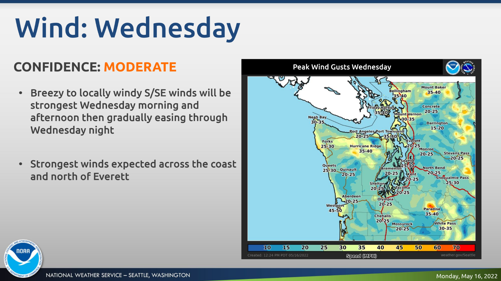
Although rain is in the forecast across the region, the National Weather Service expects lowland precipitation totals from this system will be fairly low, with about a quarter-inch of rain possible around Seattle. The wind gusts could lead to downed trees and localized power outages.
Find out what's happening in Seattlefor free with the latest updates from Patch.
For the Cascades, Snoqualmie Pass could pick up 1 or 2 inches, Stevens could see up to 6 inches, and Mount Baker could accumulate up to 18 inches.
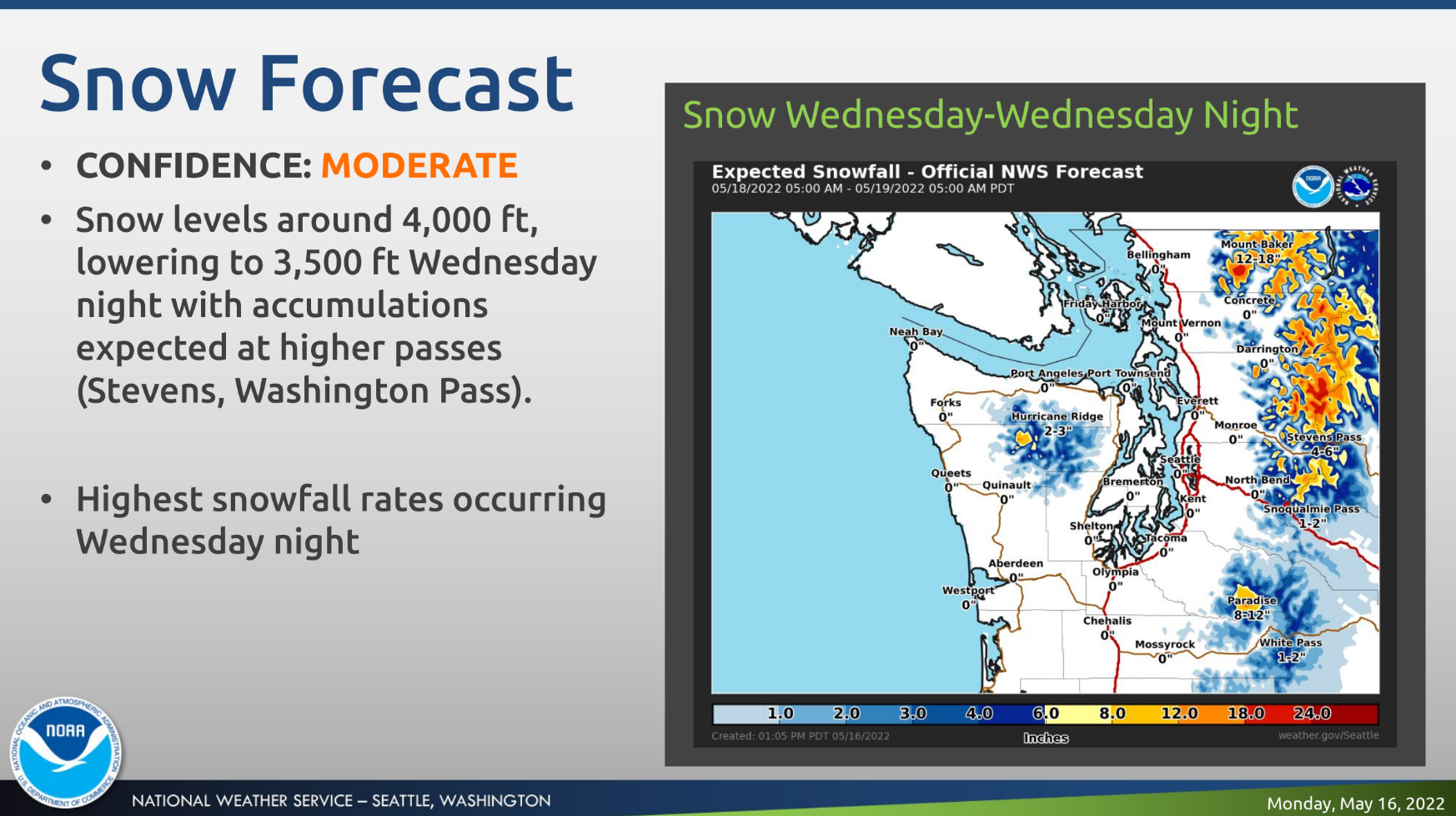
The latest unseasonable storm arrives amid an already-chilly spring, including one of the coldest Aprils in recent decades and one of the wettest first halves of May in 78 years. As of Monday, Seattle had logged more than 21 inches for the year, surpassing its typical rain totals through August 19.
Thankfully, there is some good news for late in the week, with forecasters seeing partly sunny skies and temperatures rebounding to the 60s Friday and lasting into Saturday.
Here is the five-day weather outlook for the Seattle area:
- Tuesday: 62°/47° (Partly sunny)
- Wednesday: 59°/44° (Rain/Wind)
- Thursday: 58°/43° (Chance of showers)
- Friday: 63°/46° (Partly sunny)
- Saturday: 66°/50° (Partly sunny)
Get more local news delivered straight to your inbox. Sign up for free Patch newsletters and alerts.