Weather
Warm, Sunny Saturday Before Rain Returns To Puget Sound: Forecast
Saturday promises to be sunny and pleasant across Western Washington before rain returns in full force for a soggy September send-off.



SEATTLE — Saturday is on track to bring Puget Sound its clearest skies and warmest temperatures for quite a while before a wet streak settles in for as far as the forecast can see.
After some morning clouds clear out, abundant sunshine is due across the region Saturday afternoon, with highs hitting the mid-70s around Seattle and coming close to the 80-degree mark in places like Issaquah and Puyallup. By Sunday, forecasters expect temperatures will tumble by at least 10 degrees, serving as an omen for the soggy week to come.
"The first of a series of weather systems will drag across the area on Sunday for a damp day on the Olympic Peninsula and an increasing chance of rain over the interior of Western Washington by Sunday afternoon," the National Weather Service wrote Friday. "Temperatures will cool accordingly. This sets the stage for a more active period of weather next week as we slide toward October."
Find out what's happening in Seattlefor free with the latest updates from Patch.
The storm track returns to Western Washington much of next week. The 1st system will arrive on Sunday with a 2nd on its heels for Monday. Unsettled conditions persist into Tuesday with snow levels dipping as low as 5000 feet. Stay tuned for additional details this weekend. #wawx pic.twitter.com/2NO7xi4b4B
— NWS Seattle (@NWSSeattle) September 24, 2021
Around Seattle, the latest forecasts show a 60 percent of precipitation by Sunday afternoon, growing to 90 percent by the evening, with between a quarter and half of an inch of rain possible. Heavier rain is forecast throughout Monday, with a shot for a few isolated thunderstorms.
"Almost immediately behind the front moving through Sunday is our next weather system," NWS Seattle wrote. "This system will bring more widespread rain to the region with the Olympics and North Cascades likely seeing over an inch of rain through the day. As this system moves through, ensembles are in agreement that there is roughly a 25 percent chance of thunderstorms to form throughout the region."
Find out what's happening in Seattlefor free with the latest updates from Patch.
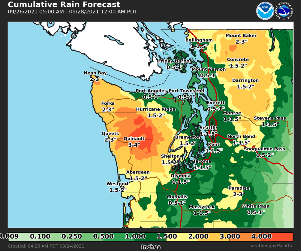
Early forecasts show rain likely straight through the end of the month Thursday and potentially carrying into October. Snow levels may drop as low as 4,500 feet by mid-week, bringing a fresh coat of snow to higher elevations in the mountains.
More details on next week's wet weather should be available in the next couple of days.
Here is the 5-day weather outlook for the Seattle area:
- Saturday: 74°/54° (Sunny, PM clouds)
- Sunday: 64°/57° (Rain likely)
- Monday: 63°/52° (Rain, chance of thunderstorms)
- Tuesday: 59°/50° (Showers, chance of thunderstorms)
- Wednesday: 61°/53° (Chance of rain)
Get more local news delivered straight to your inbox. Sign up for free Patch newsletters and alerts.