Weather
New Smoke Possible In Washington This Week: Air Quality Forecast
Forecasters are monitoring new smoke from California wildfires, which could soon begin to drift north. So far, impacts appear minimal.

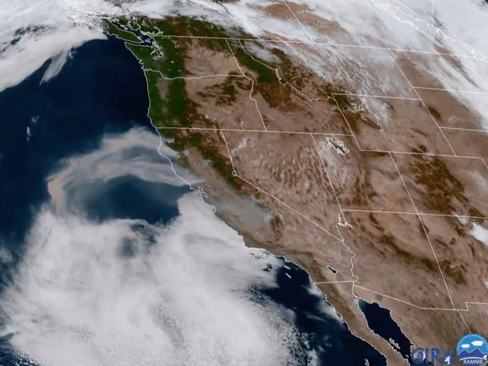
SEATTLE, WA — With rain and clouds out of the picture in Washington this week, forecasters are keeping a close eye on California smoke plumes that could shift north in the days ahead. The National Weather Service shared a new satellite loop Monday, focusing on smoke from wildfires burning in Northern California.
Latest: As Smoke Returns To Washington, Experts Hopeful It Stays Aloft
Clear skies across Washington this afternoon. You may notice a large area of smoke coming from new wildfires in Northern California. We're going to be keeping an eye on that as it may drift north over the next several days. To what extent is still unknown. #wawx #cawx pic.twitter.com/6BRLi4YOuQ
— NWS Seattle (@NWSSeattle) September 28, 2020
While the outlook will continue to evolve, early indications point to much less severe impacts than the weeklong barrage of smoke that the state only recently escaped.
Find out what's happening in Seattlefor free with the latest updates from Patch.
According to the Puget Sound Clean Air Agency, some upper-level smoke could pass over the region beginning Tuesday evening and continuing through Wednesday. Fortunately, good air quality should persist for most, sparing ground-level air from detrimental effects, and lending to especially colorful sunsets. Forecasters said there is a chance that conditions could degrade to the moderate range in some areas, but the specifics are still uncertain.
The Washington Smoke Blog's extensive recap of September's "super-massive" plume found it was too early to say for sure whether such events will become the new normal, but officials noted that three of the past four years have recorded days or weeks of unhealthy air in Seattle, Tacoma and Vancouver. The most recent bout of smoke degraded air quality below healthy ranges at every monitoring station in the state for five days.
Find out what's happening in Seattlefor free with the latest updates from Patch.
According to the blog, climate researchers also predict more acres will burn each year, as warmer winters and hotter summers create dangerous wildfire seasons.
"Whether it is a harbinger of the future or an exceptional event remains to be seen," the Department of Ecology wrote. "What 2020 has taught us, though, should be a call to action for everyone to be prepared for smoky skies and toxic air."
Live updates on air quality can be found via the Puget Sound Clean Air Agency, AirNow and Department of Ecology websites, along with the daily smoke forecast.
Unseasonably warm temperatures likely through the week
Apart from potential smoke, Sunny, mostly clear weather is forecast across Western Washington into the weekend, with afternoon highs flirting with the 80s in some areas by Wednesday. Dry conditions are expected for the foreseeable future, with highs in the mid-to-high 70s around Seattle, and in the high-60s to low-70s near Tacoma.
The normal high temperature in Seattle peaks at 77° July 19th to August 16th. Normal high today 67°, 66° Tuesday, 65° Thursday & 64° Sunday. Seattle record highs the next 4 days are all in the 80s. The record 89° set on October 1st, 1987 is the warmest Oct. day on record. #wawx pic.twitter.com/KzHEMm9E3L
— NWS Seattle (@NWSSeattle) September 28, 2020
Get more local news delivered straight to your inbox. Sign up for free Patch newsletters and alerts.
