Weather
Ice, Sleet And Snow All Headed Our Way Tuesday: Report
Plan on slippery road conditions. The hazardous conditions could impact the evening commute.

WISCONSIN -- Southeastern Wisconsin's adventures with winter weather continue Tuesday afternoon after a wintry mix will quickly over Southeastern Wisconsin, National Weather Service observers say.
The NWS says the bad weather will arrive in this afternoon in Racine and Kenosha counties and spread to the rest of the area this evening, tapering off or ending later tonight. Freezing rain and sleet will likely result in hazardous driving conditions later this afternoon through tonight, and perhaps stretching into Wednesday morning.
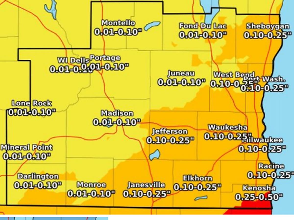
Ice accumulations between a tenth and two tenths of an inch are expected, mainly east and south of Madison. Some areas near Kenosha may approach a quarter of an inch of ice. Temperatures
will be in the 20s Tuesday night.
Find out what's happening in Brookfieldfor free with the latest updates from Patch.
Weather At A Glance:
What: Mixed precipitation expected. Total snow accumulations of up to one inch and ice accumulations of up to two tenths of an inch expected. Areas closer to the Illinois border could see amounts approaching a quarter of an inch.
Find out what's happening in Brookfieldfor free with the latest updates from Patch.
Timing: From 6 p.m. Tuesday to 6 a.m. Wednesday.
Details: Plan on slippery road conditions. The hazardous conditions could impact the evening commute.
Forecast:
Rest Of Today
Much colder. Partly sunny in the early afternoon then becoming cloudy. Highs in the mid 20s. Northeast winds 10 to 15 mph.
Tonight
Light sleet, possibly mixed with snow through around midnight. Freezing rain through the night. Chance of light sleet after midnight. Patchy fog in the late evening and overnight. Snow and sleet accumulation up to 1 inch. Ice accumulation of up to one quarter of an inch. Lows in the mid 20s. Northeast winds 5 to 10 mph. Chance of precipitation near 100 percent.
Wednesday
Cloudy. A 20 percent chance of light freezing rain late in the afternoon. Highs in the lower 30s. Northeast winds 10 to 15 mph.
NWS Graphic
Get more local news delivered straight to your inbox. Sign up for free Patch newsletters and alerts.