Weather
MD Nor'Easter: Power Outages, Hogan Says Stay Off Roads
Here is an updated look at how much snow is predicted, which counties have snow emergencies, and the Maryland forecast.


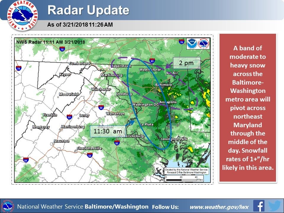
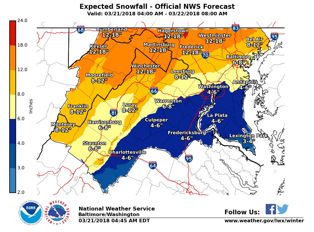
BALTIMORE, MD — If the National Weather Service is correct, the big winner from a snow accumulation standpoint will be Westminster and Frederick, where a whopping 18 inches of snow could fall, followed closely by Bel Air with a foot of snow, Baltimore with 8 inches and the Annapolis and Montgomery County areas with up to 6 inches. An update from the service just after 11:30 a.m. warns that the area of heaviest snow will fall midday across the Baltimore-DC metro with a rate of an inch or more an hour making driving difficult.
The weather service said the winter storm — hitting the state on the second day of spring — will bring conditions that rapidly deteriorate, especially along and east of the Interstate 95 corridor between Washington and Baltimore. Snowfall rates of up to 2 inches per hour will occur over the next few hours in these areas. "Please stay off the road if at all possible today as crews work to keep the roads clear," Maryland State Police asked.
Most of the state is under a winter storm warning until 8 p.m. Wednesday. The storm will start with an icy mix of precipitation that will become all snow. Snow could be heavy at times. The National Weather Service warns drivers to plan on difficult travel conditions. Be prepared for significant reductions in visibility at times.
Find out what's happening in Dundalkfor free with the latest updates from Patch.
A total of 9,034 Maryland utility customers were without power at 5 p.m. Anne Arundel County accounted for 4,040 of the outages, with 441 customers out in Kent County, 641 outages in Queen Anne's County and 143 outages in Caroline County.
Maryland State Police have responded to 572 vehicle crashes, 301 disabled vehicles, and 1,766 overall calls for service during the storm.
Find out what's happening in Dundalkfor free with the latest updates from Patch.
Gov. Larry Hogan is urging Marylanders to avoid unnecessary travel while crews work to clear roads as snow intensifies throughout the afternoon and early evening statewide. “I continue to urge all Marylanders to use common sense and stay off the roads if possible during this storm,” Hogan said. “State agencies have been working around the clock to coordinate resources and clear roads, but heavy snowfall will occur throughout much of the state this afternoon into the evening. Put your safety first, follow local weather forecasts, and be sure to heed all warnings as we continue to experience dangerous conditions.”
Statewide actions inclue:
State Highway Administration
- MDOT SHA has deployed 1,004 personnel and 2318 pieces of equipment (plows, salt trucks, etc).
- There have been incidents in counties across the state. To check current road conditions, go to roads.maryland.gov.
- Major incidents have included jackknifed tractor-trailers closed I-95 at MD 32 and I-70 at I-81 temporarily this morning. I-295 at I-195 was closed southbound earlier this morning, as well.
Maryland Transportation Authority
- Bridges have been placed on wind restrictions periodically. To view the wind policy, go to /go.usa.gov/xQcEX .
- Toll facility roads remain wet and crews continue treating roadways.
Baltimore-Washington International Thurgood Marshall Airport
- The BWI winter weather team has been in place since Tuesday night. Personnel pre-treated runways and taxiways overnight, and the airport’s winter weather employees are plowing the airfield for airline operations. Parking lots and public roadways will be treated as needed.
- Passengers with travel plans today should contact their airlines for updated flight status information. The BWI website also provides airline flight information.
Maryland Transit Administration
- For a full list of service status, go to mta.maryland.gov.
- Commuter Bus: Service is suspended.
- MARC: Service is suspended.
- Mobility: Service is suspended. Call Center is open.
- Bus: Phase 1 Service Reduction is now activated. A full list of bus diversions will be posted on the website, mta.maryland.gov. Articulated coaches were not used for the Wednesday morning peak service.
- Light RailLink: Minor delays in north and southbound service. Trains are operating at reduced speeds to maintain safety. Customers are reminded to use extra caution in and around stations and platforms.
- Metro SubwayLink: No impact to service at this time. Customers reminded to use extra caution in and around stations and platforms.
Helen Delich Bentley Port of Baltimore
- Salting and plowing will occur throughout the day as conditions dictate.
- Ships are being worked at the marine terminals. Trucks are being processed.
- There is no cruise ship scheduled until Saturday.
Maryland State Police
- Snow emergency plans are now in place in Allegany, Garrett, Baltimore, Charles, Washington, Carroll, Cecil, Frederick, Howard, Calvert, Anne Arundel, Prince George's, Caroline, Dorchester and Talbot counties.
- Under a snow emergency plan, a person may not drive or attempt to drive a motor vehicle, on any highway that is designated and appropriately signposted as a snow emergency route and for which a snow emergency has been declared and is in effect, unless the vehicle is equipped with chains or snow tires on at least one wheel at each end of a driving axle.
- A person may not park a vehicle on any highway that is designated and appropriately signposted as a snow emergency route and for which a snow emergency has been declared and is in effect. Any person who parks on effect snow emergency routes may have their vehicle towed.
- Road conditions will be closely monitored and the snow emergency plan will be lifted when the roads are determined to be safe for normal travel.
With the wet snow, be prepared for a power outage as well. If you must travel, keep an extra flashlight, food and water in your vehicle in case of an emergency. The latest road conditions are available by calling 5 1 1.
Have snow photos? Add them in comments or email them to deb.belt@patch.com.
The Maryland Transportation Authority says travel conditions will change rapidly as precipitation moves back in and urges residents to consider canceling travel plans. Icy spots are possible at this time. Remember bridges, overpasses and infrequently traveled roads will freeze first. Keep in mind that what looks wet may be ice.
For real-time updates on major incidents follow the authority on Twitter attwitter.com/TheMDTA or click the Twitter app. Call 1-877-BAYSPAN (229-7726) for current traffic conditions at the Bay Bridge. To view real-time traffic camera images on MDTA roadways, visit mdta.maryland.gov.Call 511 or visit MD511.org for statewide travel information.
SEE ALSO:
- Maryland School Closings List For Wednesday, March 21
- Closings In Harford County On Wednesday, March 21
- Harford County Declares Snow Emergency
- Montgomery County Winter Storm: What's Open, Closed
- Anne Arundel Snowstorm: Parking, Street Plowing, Who To Call
- Snow Closures In Howard County On Wednesday, March 21, 2018
- Baltimore County Snow Closures On Wednesday, March 21
AAA offers the following tips for driving on snowy or icy roads:
- Accelerate and decelerate slowly; it takes longer to slow down on icy roads.
- Turn the steering wheel in the direction your wheels are going if you start to skid. Do not hit brakes or gas.
- Increase following distance.
- Use the ball of your foot to apply firm, steady pressure on the brake pedal.
- Don't stop if you can help it. Slow down enough to stay moving until a traffic light changes.
- Don't speed up or stop going uphill. Try to get momentum going on a flat surface before you reach a hill and let inertia carry you to the top. At the crest of the hill, reduce your speed. Proceed as slowly as possible.
Important Maryland Utility Numbers:
- BGE: 1-877-778-2222 for outages or 1-800-685-0123 for downed wires.
- Delmarva Power at 1-800-898-8042.
- First Energy/Potomac Edison: 1-888-544-4877
- PEPCO: 1-877-737-2662
- SMECO: 1-877-747-6326 or 1-888-440-3311
- Washington Gas: 1-800-752-7520
- Washington Suburban Sanitary Commission: 1-800-828-4002
For more news like this, find your local Patch here. If you have an iPhone, click here to get the free Patch iPhone app; download the free Patch Android app here.
Maryland Weather Forecast:
Wednesday: Snow, possibly mixed with sleet, becoming all snow after 11am. The snow could be heavy at times. High near 33. North wind around 11 mph, with gusts as high as 21 mph. Chance of precipitation is 100%. Total daytime snow and sleet accumulation of 3 to 7 inches possible.
Wednesday Night: Snow, mainly before 11pm. Low around 26. Northwest wind around 14 mph, with gusts as high as 22 mph. Chance of precipitation is 80%. New snow accumulation of around an inch possible.
Thursday: Partly sunny, with a high near 41. Northwest wind 14 to 16 mph, with gusts as high as 26 mph.
Thursday Night: Partly cloudy, with a low around 26. Northwest wind 8 to 11 mph, with gusts as high as 20 mph.
Friday: Mostly sunny, with a high near 42. Northwest wind 8 to 13 mph, with gusts as high as 22 mph.
Friday Night: Mostly clear, with a low around 25.
Saturday: Sunny, with a high near 43.
Saturday Night: Mostly cloudy, with a low around 27.
Sunday: Mostly sunny, with a high near 43.
Sunday Night: Partly cloudy, with a low around 27.
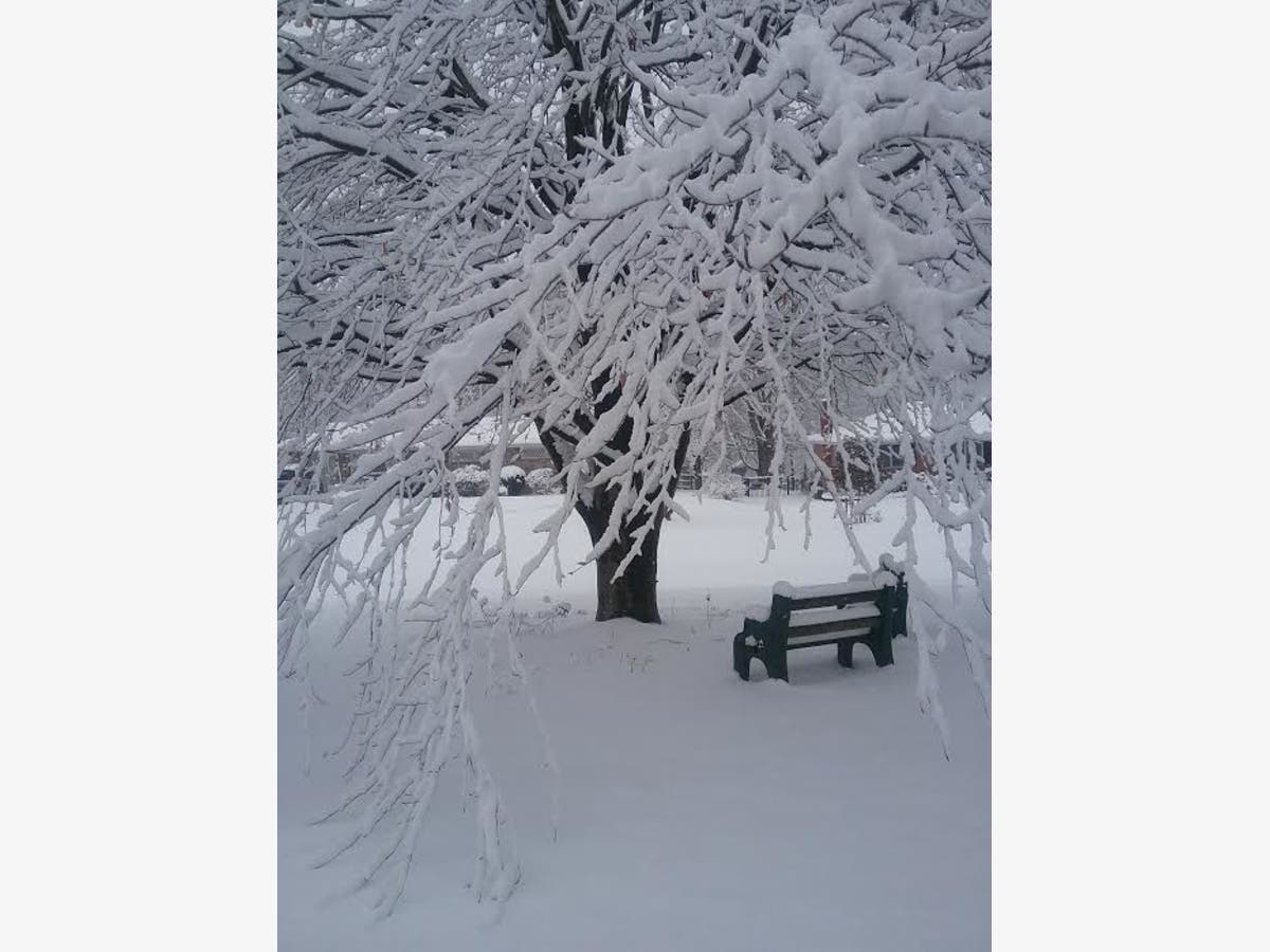
Main image of Patch reader Sandy Lundahl's yard in Ellicott City
Get more local news delivered straight to your inbox. Sign up for free Patch newsletters and alerts.


