Weather
Unusually Cool Temps Hit Phoenix Before 100-Degree Heat Returns
Enjoy the cool weather while it lasts, Phoenix, because triple digits are coming by the weekend, forecasters warn.

PHOENIX, AZ — Phoenix is getting a brief break from the heat this week, but it won't last long.
Temperatures across the Valley will stay unusually cool through Tuesday, with afternoon highs expected to reach only the low 80s Monday and potentially struggle to hit 80 degrees Tuesday.
That puts the area roughly 5 to 15 degrees below normal for early May, according to the National Weather Service.
Find out what's happening in Phoenixfor free with the latest updates from Patch.
The cool-down is tied to a low pressure system moving inland from the California coast and pushing across Southern California and Arizona on Tuesday. Thick cloud cover is expected to limit daytime heating, keeping temperatures in check through midweek.
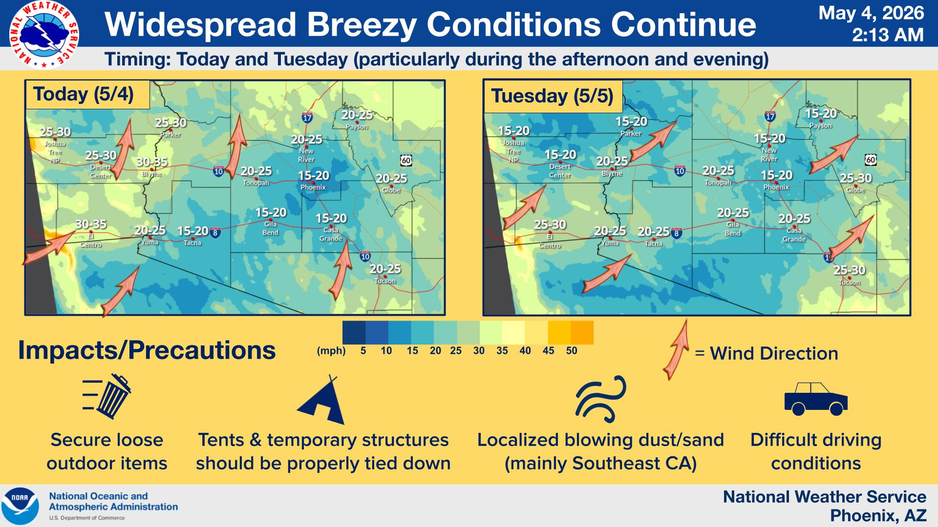
Along with the cooler temps, expect some wind, forecasters warn.
Find out what's happening in Phoenixfor free with the latest updates from Patch.
Gusts of 20 to 30 mph are likely through Tuesday across much of the region. Areas to the west could see stronger gusts, with some spots in southwestern Imperial County potentially hitting 40 mph or more.
There is also a slight chance of rain, though don't get too excited. Subtropical moisture moving into southern and eastern Arizona could bring light showers Monday evening into overnight hours, mainly across southeast Arizona and higher terrain south and east of Phoenix.
Most rainfall totals are expected to stay below 0.10 inch, and the greater Phoenix area may see only a few stray drops.
For those flying out of the Valley, no major disruptions are expected at Phoenix-area airports.
However, sustained winds and periodic gusts around 20 knots are possible late Monday. Scottsdale and Deer Valley airports could also see some hazy conditions and reduced visibility tied to the brush fire burning in Buckeye.
The pleasant weather ends fast. Temperatures are forecast to climb into the 90s by Thursday and could hit triple digits as early as Friday as high pressure builds across the western United States.
The National Weather Service says heat risk levels across most of the area are expected to increase into the moderate category as highs push into the 100s heading into the weekend.
So if you have outdoor plans, this week's first half is your window.
Get more local news delivered straight to your inbox. Sign up for free Patch newsletters and alerts.