Weather
From Bone Dry To Devastating Floods: California's Spring Forecast Released
California's spring outlook is looking rather rosy, but more flooding may be in the cards as the state's robust snowpack continues to melt.

CALIFORNIA — California's drought has already been cut in half, and residents can expect conditions to improve almost across the board as spring gets underway in the Golden State. The vernal equinox arrives Monday afternoon.
The National Oceanic and Atmospheric Administration (NOAA) released its official U.S. spring outlook Thursday, predicting widespread drought relief and lingering flood risks as a historic snowpack begins to melt.
The release of the spring outlook arrived the same day that federal climatologists updated the U.S. drought monitor, showing stunning improvements since the water year began in October. California started off with 99 percent of the state under drought conditions, a figure that is now down to 36 percent. Nearly 100 percent of the Bay Area is classified as drought-free.
Find out what's happening in Across Californiafor free with the latest updates from Patch.
NOAA said Thursday that drought conditions nationwide were at their lowest levels since 2020 and expected to continue to improve, or outright end, through the season in California and the Great Basin.
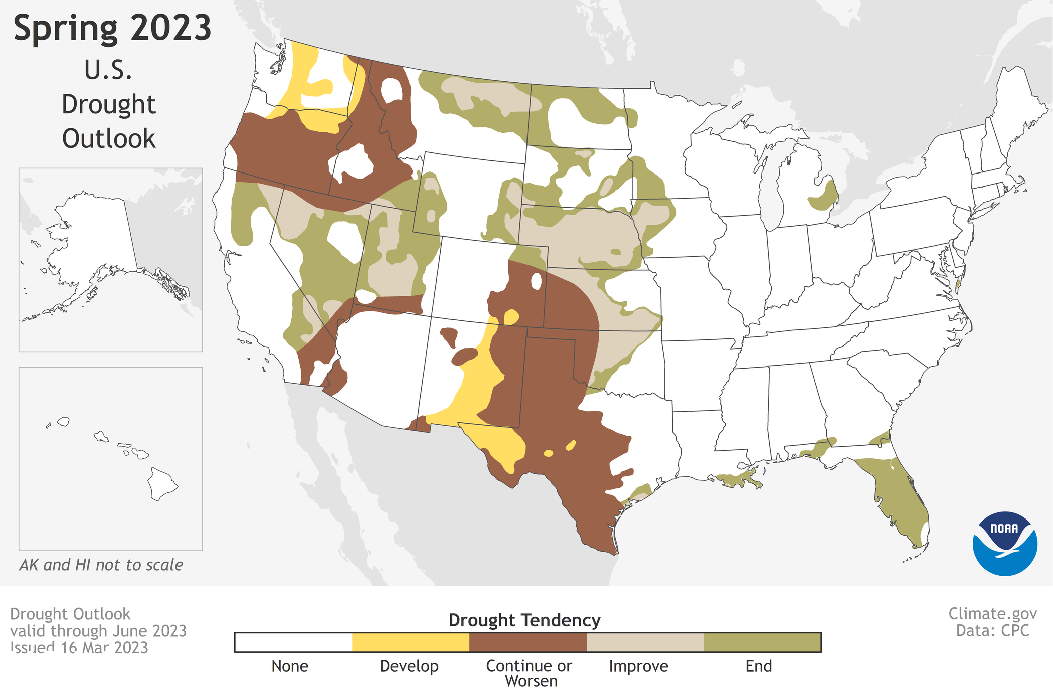
While California's spring outlook is largely positive, forecasters cautioned that very high snowpack and moist soil will create new flooding risks this season.
Find out what's happening in Across Californiafor free with the latest updates from Patch.
"Approximately 44% of the U.S. is at risk for flooding this spring," said Ed Clark, director of NOAA's National Water Center. "California's historic snowpack, coupled with spring rain, is heightening the potential for spring floods."
And historic it is. This week California's snowpack reached 215 percent of its peak average, and could well soar to the top of the record books by the end of the month.
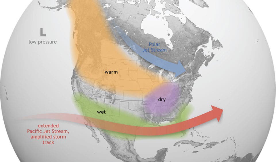
Another change in the air has already materialized with the departure of La Niña, whose presence has been felt since 2020, and the likely arrival of its counterpart, El Niño.
"La Niña has finally ended after being in place continuously for more than two years," said Jon Gottschalck, of NOAA's Climate Prediction Center. "ENSO-neutral — the transition period between El Niño and La Niña — is likely to continue into the early summer with elevated chances of El Niño developing thereafter."
El Niño can have significant impacts on weather in the western hemisphere, as warmer waters push the Pacific jet stream south. Typically, this brings drier and warmer weather to the northern parts of the U.S. and Canada, while bringing wetter conditions to the South and Southwest, including Southern California.
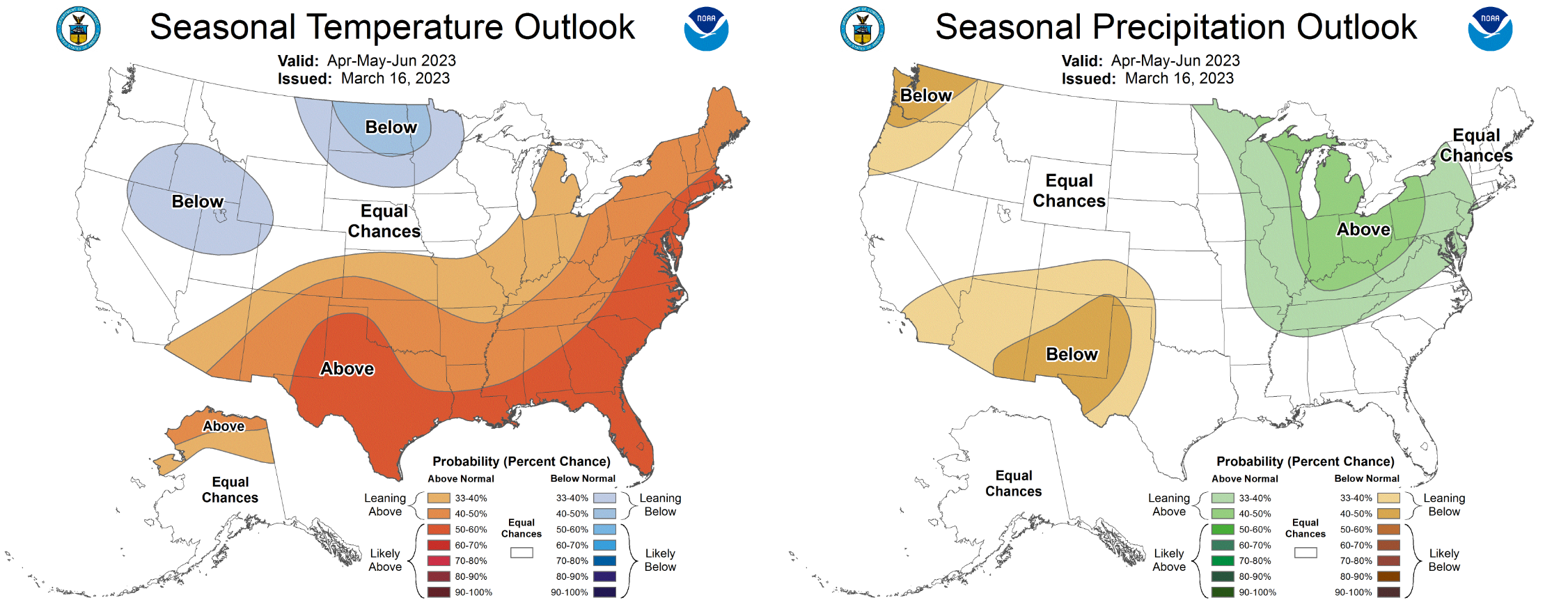
In some ways, California may be in for a classic spring, with updated seasonal outlooks now showing equal chances for temperatures and precipitation to land below or below average into June. Elsewhere in the country, climatologists favor hotter temperatures for much of the southern and eastern parts of the country, especially in the High Plains and Forida. Parts of the Great Basin and northern Plains may see things running colder than usual.
Get more local news delivered straight to your inbox. Sign up for free Patch newsletters and alerts.