Crime & Safety
Cranston Fire Day 3: 11,500 Acres, Containment Decreases, Map
The fire grew by 4,000 acres overnight. Here are all the latest stats on the blaze.


MOUNTAIN CENTER, CA — A fast-moving brush fire in the San Bernardino National Forest in Riverside County was only slightly contained Friday after blackening at least 11,500 acres, threatening communities and prompting the evacuation of thousands of people. Before crews entered the third day of fighting, the massive blaze's estimated size increased by 4,000 acres overnight and the estimated containment decreased from 5 percent to 3 percent.
More than 1,300 firefighters from agencies across the state are now battling the Cranston Fire, which has destroyed at least five homes and prompted road closures and the evacuation of 6,000 people in Mountain Center, Idyllwild, Herkey Creek, San Jacinto Mountain State Park, Fern Valley, Pine Cove, Cedar Glen and the northern section of Garner Valley, according to the U.S. Forest Service.
"Yesterday’s fire behavior remained very active...which was verified by infrared last night with an increase of hot spots detected; however, all hot spots remain inside the fire perimeter," the U.S.F.S. said Friday morning.
Find out what's happening in Banning-Beaumontfor free with the latest updates from Patch.
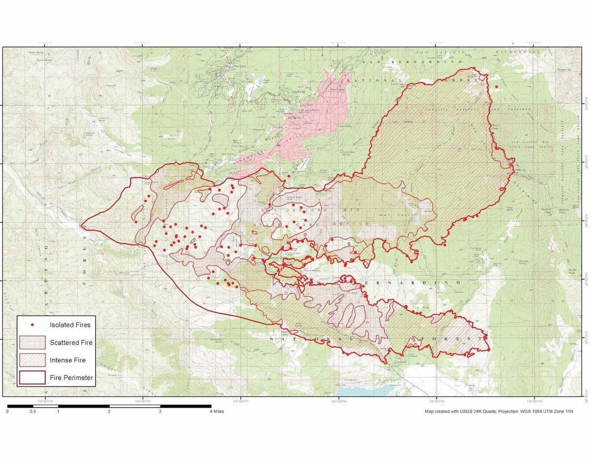
Below is the latest fire map, released Friday morning:
Here are some quick stats on the blaze:
- Location of Origin: East of Cranston Fire Station
- Start date: July 25, 2018, 11:57 am
- Size: Approximately 11,500 acres
- Percent Contained: 3 percent
- Cause: Arson
- Resources Assigned: 1393 personnel
- Structures threatened: 4,830
- People Evacuated: 6,000
- Firefighter Injuries: 2
- Civilian Injuries: 0
As for evacuations, here is the latest information from the U.S. Forest Service:
- Evacuation Center: Banning High School, 100 W. Westward Ave., Banning, CA
- Animal Evacuation Centers: Dysart Equestrian Park 2101 W. Victory Ave Banning, CA Banning High School (small animals only) 100 W. Westward Ave Banning, CA Riverside County Animal Services - San Jacinto Valley Animal Campus 581 S. Grand Ave San Jacinto, CA Road Closures: Highway 243 is closed from Banning to Highway 74 (Residents north of Marion Ridge Drive with ID can enter at Banning). Highway 74 is closed from Cranston Station to Highway 371.
- Evacuation Warning: This is NOT an Evacuation Order. This is an advisement only of potential Evacuation Order should conditions change: Southside of Garner Valley (All homes south of Hialeah Way, including homes accessed from Hialeah Way, are under evacuation warning through just south of Highway 371)
- Mandatory Evacuations: Areas that are currently under a mandatory evacuation include: The entire Mountaintop communities of: Mountain Center, Idyllwild, Herkey Creek, San Jacinto Mountain State Park, Fern Valley, Pine Cove and Cedar Glen. The northern section of Garner Valley is also under a mandatory evacuation (All homes accessed from roads north of Hialeah Way, not including homes accessed via Hialeah Way).
An excessive heat warning was extended to midnight Friday, according to the National Weather Service.
Find out what's happening in Banning-Beaumontfor free with the latest updates from Patch.
Authorities issued a smoke advisory for the region, advising that winds could bring smoke into various parts of Riverside County, including the Coachella Valley, Banning Pass, the Hemet/San Jacinto Valley, Perris Valley and Anza. The advisory will be in effect through Friday morning and possibly longer.
A fire information call center for the public has been established at (909) 383-5688.
#CranstonFire [update] off Highway 74 and Control Road, east of Hemet (Riverside County) is now 11,500 acres and 3% contained. Unified Command: CAL FIRE/Riverside County Fire and San Bernardino National Forest https://t.co/tEZx1sFiep pic.twitter.com/6feFXqKs5Y
— CAL FIRE (@CAL_FIRE) July 27, 2018
— City News Service contributed to this report / Image via Palo Alto Fire Department
Get more local news delivered straight to your inbox. Sign up for free Patch newsletters and alerts.