Crime & Safety
Evacuation Orders & Warnings Lifted For Healdsburg, Sonoma Coast
While officials canceled some orders and warnings, others are still in place throughout Sonoma County.

SONOMA COUNTY, CA — Evacuation orders and warnings, stemming from the LNU Lightning Complex fires, were lifted Tuesday afternoon in Healdsburg and on the Sonoma Coast, according to officials.
The Sonoma County Sheriff’s Office lifted orders and warnings in the following areas:
Map Grid 1D1 all orders lifted:
Find out what's happening in Healdsburgfor free with the latest updates from Patch.
- East of the Sonoma Coast
- North of the Russian River
- West of Myers Grade Road
- South of Fort Ross Road
Map Grid 1D2 all orders lifted:
- East of Myers Grade Road
- North of Russian River
- West of Cazadero Highway
- South of Fort Ross Road
Map Grid 1D3 all orders lifted:
Find out what's happening in Healdsburgfor free with the latest updates from Patch.
- East of the Cazadero Highway
- North of Russian River
- West and South of Old Cazadero Road
Map Grid 1C1 all orders lifted:
- East of the Sonoma Coast
- North of Fort Ross Road
- West of the south fork of Gualala River
- South Stewarts Point Skaggs Springs Road
Map Grid 1C2 all orders lifted:
- East of the south fork of the Gualala River
- North of Fort Ross Road
- West and South of King Ridge Road
Map Grid 1E1 all orders lifted:
- All areas south and west of Willow Creek Road
- North of Coleman Valley Rd. and Wright Hill Road
- East of the California Coastal National Monument (BLM property)
Map Grid 1E3 all orders lifted:
- All areas south of the Russian River
- West of Bohemian Hwy.
- North and East of Coleman Valley Road and Willow Creek Road
Map Grid 1F1 all orders lifted:
- All areas east of Bohemian Hwy.
- North of Graton Road and Harrison Grade Road
- West of Harrison Grade Rd., Green Valley Road and Hwy. 116
- South of the Russian River
Map Grid 1F2 all orders lifted:
- All areas south of the Russian River
- East and North of Hwy. 116 (Pocket Canyon)
- West of Martinelli Road
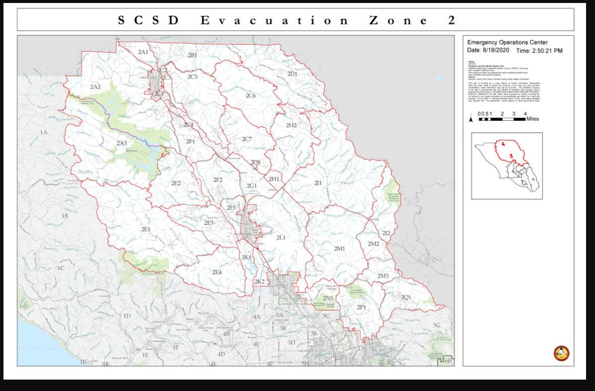
Map Grid 2C4 all orders lifted:
- South and West of Asti Road
- East of Hwy 101
- North of Hwy 128
Map Grid 2F1 all orders lifted:
- North of Canyon Road
- West of Dutcher Creek Road and the Dry Creek the actual creek
- West of Hwy 101
Map Grid 2F2 all orders lifted:
- South of Canyon Road
- East of the Dry Creek (the actual creek)
- North of Lytton Springs Road
- West of Geyserville Avenue
Map Grid 2F3 all orders lifted:
- South of Lytton Springs Road
- East of the Dry Creek (the actual creek)
- North of Westside Road
- West of the Healdsburg city limits.
Map Grid 2G1 all orders lifted:
- East of Hwy 101
- South and West of Hwy 128
- North of Alexander Valley Road
Map Grid 2K1 all orders lifted:
- All areas North and East of Westside Road
- South of Hwy. 101
- West of the Russian River
Map Grid 2K2 all orders lifted:
- All areas west of Hwy. 101
- East of the Russian River to the Windsor Town limits
- North of where Windsor River Road dead ends, extending west to the Russian River.
Map Grid WI-A (Town of Windsor) all orders lifted:
- North of Windsor River Road to the northern town limit
- West of Hwy 101 to the western town limit
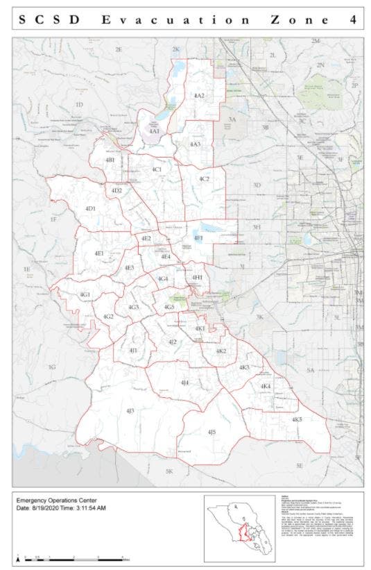
Map Grid 4A1 all orders lifted:
- All areas East of the Russian River
- North of River Road
- West of Trenton Healdsburg Road and Eastside Road
- South of the area between the western dead end of Windsor River Road and the Russian River
Map Grid 4A2 all orders lifted:
- East of Trenton Healdsburg Road
- North of Mark West Station Road
- West of the Windsor City Limits and Windsor Road
- South of Windsor River Road
Map Grid 4A3 all orders lifted:
- East of Trenton Healdsburg Road
- North of River RoadWest of Slusser Road
- South of Mark West Station Road
Map Grid 4B1 all orders lifted:
- All areas south of River Rd. from Martinelli Rd. to the intersection of River Road at Trenton Road
- West of Covey Road.
- North of Front Street/ Hwy. 116
- East of Martinelli Road
Map Grid 4C1 all orders lifted:
- North of Guerneville Road
- East of Covey Road and Hwy 116
- West of Laguna Road
- South of River Road
Map Grid 4D1 all orders lifted:
- South of Pocket Canyon/Hwy 116
- East and North of Green Valley Road
- West of Atascadero Creek
Map Grid 4D2 all orders lifted:
- South and West of Hwy 116
- East of Atascadero Creek
- North of Green Valley Road
Officials noted that River Road and Highway 116 will remain closed from the Hacienda Bridge to Old Cazadero Road and Highway 116 will also be closed at Drake Road coming into Guerneville. Locals going to the Monte Rio, Camp Meeker, Jenner and the Cazadero areas are advised to use alternate routes to return home.
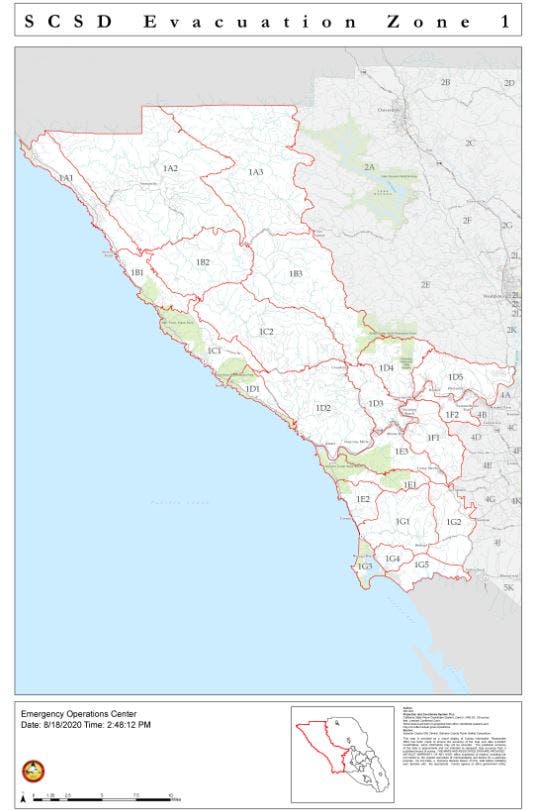
All other areas under evacuation order are still closed. FOLLOW THIS LINK TO EVACUATION MAP.
Those living in the above listed areas are clear to return home, officials said, adding that residents must continue to follow instructions from first-responders, listen for hi-lo sirens and use caution around any burned areas.
The fires also may have disrupted PG&E services, but the utility "is working around-the-clock to restore services to all its (affected) customers," deputies said. Anyone with questions about gas or power can check the PG&E website or call 1(800)743-5000. Any downed power lines should be treated as "live," and PG&E should be contacted.
Here are evacuation changes issued Monday for Sonoma County.
-----------------
ALSO SEE:
Get more local news delivered straight to your inbox. Sign up for free Patch newsletters and alerts.