Weather
12 Inches Of Snow Expected In RivCo Mountains Near Elsinore
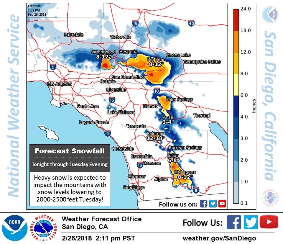
Bundle up, Riverside County! Area mountains may see up to 12 inches of snow!

RIVERSIDE COUNTY, CA — After several days of cold — yet dry — weather across the Inland Empire, an approaching cold front is expected to dump rain and snow in the region overnight Monday into Tuesday. Mountains in the Southland will get up to a foot of snow in this storm, according to the National Weather Service.
Described as "very cold" storm, the system is going to bring "widespread rain and snow," weather officials said on Monday afternoon.
"We expect our mountain community locations at 5,000 to 6,000 feet to see anywhere from six to 12 inches of snow," Meteorologist Alex Tardy said in the video briefing embedded above. "We'll even see some wet snowflakes all the way down to 2,000 feet on Tuesday."
Find out what's happening in Lake Elsinore-Wildomarfor free with the latest updates from Patch.

As a result, commuters are being asked to prepare for hazardous driving conditions on Tuesday.
"Snowfall will make slippery road conditions and possibly impassable for a time at higher elevations," meteorologists said. "Blowing snow and fog will reduce visibility at times."
Find out what's happening in Lake Elsinore-Wildomarfor free with the latest updates from Patch.
Some highlights of this storm are:
- Heavy snow is predicted around 4,000 feet, with about 6 to 12 inches expected
- 2 to 4 inches of snow are expected to fall above 2,500 feet
After this upcoming storm, wet and cool weather is expected to continue through the end of the work week, according to NWS forecasts.
Here's the National Weather Service forecast for Lake Elsinore for the coming days:
Monday Afternoon
Rain likely after 4pm. Mostly sunny, with a high near 63. Southwest wind 10 to 15 mph, with gusts as high as 20 mph. Chance of precipitation is 60%.
Monday Night
Rain. Low around 39. Southwest wind 5 to 10 mph becoming northwest after midnight. Chance of precipitation is 90%.
Tuesday
Showers likely before 10am, then showers likely and possibly a thunderstorm between 10am and 4pm, then a slight chance of showers and thunderstorms after 4pm. Mostly cloudy, with a high near 50. Light and variable wind becoming southwest 5 to 10 mph in the afternoon. Chance of precipitation is 70%.
Tuesday Night
A 20 percent chance of showers before 10pm. Patchy frost after 10pm. Otherwise, mostly cloudy, then gradually becoming mostly clear, with a low around 35. West wind around 5 mph becoming calm.
Wednesday
Patchy frost before 10am. Otherwise, sunny, with a high near 57. Light south wind becoming southwest 5 to 10 mph in the afternoon.
Wednesday Night
Partly cloudy, with a low around 41.
Thursday
Partly sunny, with a high near 57.
Thursday Night
Rain likely. Mostly cloudy, with a low around 42.
Friday
Showers likely. Partly sunny, with a high near 55.
— Image via Ey Mariya, Shutterstock.com
Get more local news delivered straight to your inbox. Sign up for free Patch newsletters and alerts.