Weather
Heavy Rain, Snow To Fall Near Elsinore In Trifecta Storm Series
Get ready for some more storms! Plus, see some preliminary precipitation totals from around the region.

RIVERSIDE COUNTY, CA — Well, it's no polar vortex, but the Lake Elsinore and Wildomar areas will again be slammed with our own SoCal version of winter weather. The second of three storms predicted to sweep through the Inland Empire in quick succession will hit the region Friday evening through Sunday morning, bringing heavier precipitation than the first storm throughout Riverside County, according to the National Weather Service.
"This is a stronger storm than Thursday's in terms of wind and precipitation," according to the NWS.
The final wave of the storm is expected to come around Tuesday night, the NWS said.
Find out what's happening in Lake Elsinore-Wildomarfor free with the latest updates from Patch.
-1549039906-4215.jpg)
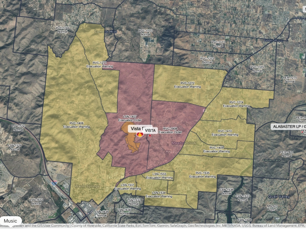
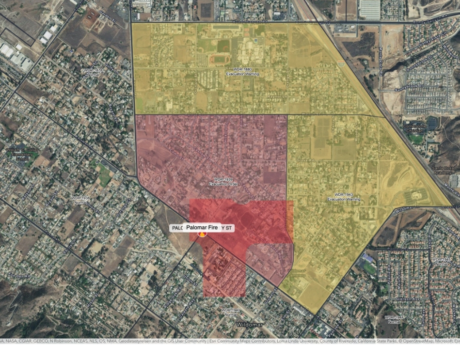
The storm series prompted county officials to issue mandatory evacuation orders on Thursday for select areas near the recent Holy Fire burn area. More evacuations will likely be ordered in the coming days and EMD officials urged residents to stay alert for evacuation orders and check maps at www.RivCoReady.org/StormReady for the latest information.
In a 24-hour period ending around 3 a.m., Temecula had received the highest rainfall in western Riverside County at .63 inches. Beaumont recorded .55 inches; Lake Elsinore .39 inches; Riverside Municipal Airport about .34 inches and Palm Springs about .19 inches, according to the National Weather Service.
Find out what's happening in Lake Elsinore-Wildomarfor free with the latest updates from Patch.

The Riverside metropolitan area could get up to 1.2 inches of rainfall Saturday while Lake Elsinore is expected to see up to 1.8 inches and the San Gorgonio Pass near Banning is forecast to get around 2 inches, meteorologists said. Up to 2.4 inches of rainfall is predicted for Idyllwild Saturday and the Coachella Valley will receive around a half-inch.
The NWS issued a flash flood watch that will last from Saturday morning through Saturday evening for the county mountains, valleys, the Riverside metropolitan area and the San Gorgonio Pass near Banning. The Coachella Valley was not included in the flash flood watch.
As for Lake Elsinore in particular, here's what that National Weather Service is forecasting:
Friday
A chance of rain after 5pm. Mostly sunny, with a high near 62. Calm wind becoming south around 5 mph in the afternoon. Chance of precipitation is 30%. New precipitation amounts of less than a tenth of an inch possible.
Friday Night
Rain, mainly after 11pm. Low around 50. South wind 5 to 10 mph. Chance of precipitation is 80%. New precipitation amounts of less than a tenth of an inch possible.
Saturday
Rain. The rain could be heavy at times. High near 60. Windy, with a southeast wind 10 to 20 mph increasing to 20 to 30 mph in the afternoon. Winds could gust as high as 45 mph. Chance of precipitation is 100%. New precipitation amounts between 1 and 2 inches possible.
Saturday Night
Rain before 11pm, then showers likely after 11pm. The rain could be heavy at times. Low around 46. Southwest wind 10 to 15 mph becoming light. Winds could gust as high as 25 mph. Chance of precipitation is 80%. New precipitation amounts between three quarters and one inch possible.
Sunday
A chance of showers. Mostly cloudy, with a high near 56. Southwest wind 10 to 15 mph, with gusts as high as 25 mph. Chance of precipitation is 40%. New precipitation amounts between a tenth and quarter of an inch possible.
Sunday Night
A chance of showers. Mostly cloudy, with a low around 44. Chance of precipitation is 50%.
Monday
Showers likely. Mostly cloudy, with a high near 55. Chance of precipitation is 60%.
Monday Night
A chance of showers. Mostly cloudy, with a low around 42.
Tuesday
A slight chance of showers. Mostly cloudy, with a high near 55.
Tuesday Night
Partly cloudy, with a low around 39.
--
— Main image by Renee Schiavone
Get more local news delivered straight to your inbox. Sign up for free Patch newsletters and alerts.