Weather
When Will The Rain Arrive In Lake Elsinore? Back-To-Back Storms On The Way
Rain, wind and falling temperatures are expected in Lake Elsinore, Wildomar and across Southwest Riverside County. How cold will it get?


LAKE ELSINORE, CA —Two inbound storm systems will drop temperatures in Lake Elsinore through the remainder of the week, bringing rain and more mountain snow to lower elevations, the National Weather Service San Diego reports.
A winter storm is in effect in the Riverside County mountains Thursday evening through Sunday morning, with the added warning of possible heavy snow and strong winds.
Forecasters predicted rain to arrive in Lake Elsinore after 10 p.m. Thursday night, with a 70 percent chance of rain all day Friday.
Find out what's happening in Lake Elsinore-Wildomarfor free with the latest updates from Patch.
Lake Elsinore's Detailed Weather Forecast: NWS:
Thursday:
Mostly sunny, with a high near 69. South wind 5 to 10 mph, with gusts as high as 20 mph.
Find out what's happening in Lake Elsinore-Wildomarfor free with the latest updates from Patch.
Thursday Night:
A slight chance of showers, then showers and possibly a thunderstorm after 10pm. Low around 46. South wind 5 to 10 mph. Chance of precipitation is 80%. New rainfall amounts between a quarter and half of an inch possible.
Friday:
Showers and possibly a thunderstorm. High near 55. Light west wind becoming southwest 10 to 15 mph in the afternoon. Winds could gust as high as 25 mph. Chance of precipitation is 90%. New rainfall amounts between a quarter and half of an inch possible.
Friday Night:
A chance of showers and thunderstorms. Mostly cloudy, with a low around 43. Southwest wind 10 to 15 mph becoming light and variable after midnight. Winds could gust as high as 20 mph. Chance of precipitation is 30%. New precipitation amounts of less than a tenth of an inch, except higher amounts possible in thunderstorms.
Saturday:
A chance of showers. Partly sunny, with a high near 53. West wind 10 to 20 mph, with gusts as high as 30 mph. Chance of precipitation is 40%. New precipitation amounts of less than a tenth of an inch possible.
Saturday Night:
A chance of showers, mainly before 10pm. Partly cloudy, with a low around 38. Chance of precipitation is 30%.
Sunday:
Mostly sunny, with a high near 58.
Sunday Night:
Mostly clear, with a low around 39.
Wind-prone areas could see gusts of up to 25 miles per hour are possible between the storms.
As much as 2 feet of snow could fall above 6,000 feet, with 1 to 5 inches possible at lower elevations down to 4,000 feet, according to the weather service. The first system will arrive Thursday evening and into Friday, followed by another round of precipitation Friday night into Sunday.
"Snowy and windy conditions with significant reductions in visibility are possible, especially during the morning commute on Friday," according to the NWS.
A wind advisory will also be in effect for Riverside County mountains from noon through midnight.
Wind gusts of up to 70 mph are possible in some areas.
Temperatures were forecast to start falling Thursday, plummeting further on Friday and Saturday.

"The weather will turn sharply colder Friday through Sunday as a series of shortwaves in cold northwest flow brings rain, wind and mountain snow," according to the NWS.
Weather service officials said Southwest Riverside County should expect approximately a quarter-inch of rain. t
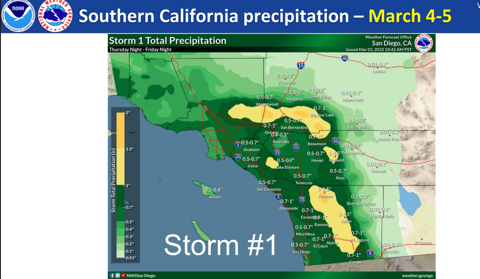
The San Diego County mountains will likely receive the most precipitation during the first wave of the storm, with 1 to 1.75 inches of rain possible, while coastal and valley areas could get between a quarter-inch to an inch of rain.
Desert areas will see 0.1 to 0.25 inches, forecasters said.
As the second front moves into the region Saturday, more rain will fall in mountain areas, along with another quarter-inch possible in valley areas. Meanwhile, the snow level will drop to about 3,500 feet, with "several more inches" of snow likely.
Get more local news delivered straight to your inbox. Sign up for free Patch newsletters and alerts.