Politics & Government
District Elections Are Coming - Take a Closer Look
Looking at contiguity, natural boundaries, and communities of interest
We've been examining the proposed district maps and the extent to which the maps met the criterion of "one person one vote" (Click Here). Adhering to the "one person one vote" mandate is the main consideration in drawing up district maps, but it isn't the only consideration. Other considerations include adherence to natural boundaries, having districts contiguous, and maintaining communities of interest.
CONTIGUITY
All 12 maps had contiguous districts. One map (#114) was characterized by the demographers as "barely" contiguous but I think they made a mistake. The barely contiguous map seems to be #103.
NATURAL BOUNDARIES
The City has a few "natural boundaries".
Find out what's happening in Lake Forestfor free with the latest updates from Patch.
- In the East we have the mountains , generally identified as beginning with the 241 and including Foothill Ranch and Portola Hills.
- In the South we have Aliso Creek (AC), generally identified with homes to the South of El Toro Rd.
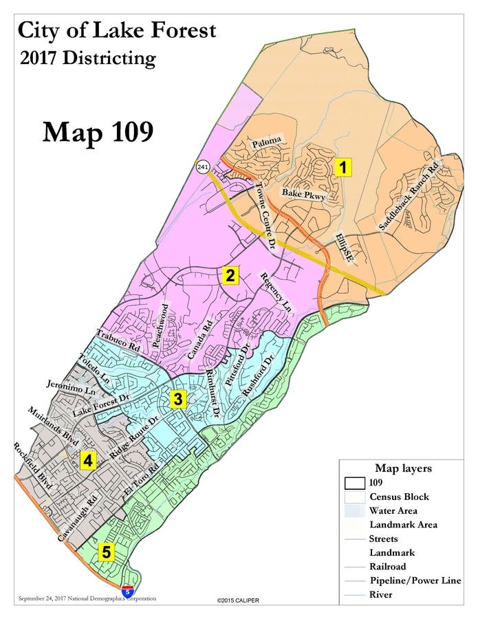
All the maps but one (#109) violated at least one of these natural boundaries, and some of the maps violated all of them. Here's a list of the maps with the least boundary breaking. (Note - AC refers to a major breakup of homes south of Aliso Creek and ac = a minor breakup).
- Map #109 -
- Map #114 - ac
- Map #116 - AC,
- Map #127 - AC,
COMMUNITIES OF INTEREST
You can't make an omlette without scrambling some eggs, and this is also true with making district maps. All the proposed plans appear to break up at least one "community of interest", and some plans do a lot more. Here are some of the common break-ups -
Find out what's happening in Lake Forestfor free with the latest updates from Patch.
PORTOLA HILLS AND FOOTHILL RANCH
PH and FHR have a total of about 17,000 residents and the ideal number for the 5 districts is 15,453. So it's impossible to include both of these areas in one district. Some people addressed this by breaking them up into two distinct areas and combining them with other sections of the city (Maps #111, 112, 115). Most of the others addressed this by including 15,000+ into one district and then siphoning off the additional 2,000 residents, always from the extreme north/west part of the area.
LAKE 1
Lake 1 has 1,800 homes and about 5,000 residents. Most maps broke Lake 1 into two or more major sections but two maps kept Lake 1 intact (Map #108 and 109) and 1 map kept Lake 1 mostly intact (Map #114)
LAKE 2
Lake 2 has 3,600 homes and about 10,000 residents. All the maps broke Lake 2 into two or more sections, but a few of the maps managed to keep 80% or more of Lake 2 intact (Maps #106, 108, 109, and 115).
CREEKSIDE
The area East of Trabuco and South of E l Toro represents a relatively homogeneous group of homes that are set between Mission Viejo and Aliso Creek. Most maps broke this area up into separate districts, but a few managed to keep them together (Maps #109, 110, 112, 127) and for a number of others the separation was minor (Maps #105, 108, 111, 114, 116)
MOBILE HOMES
All but one of the maps separated the 4 mobile homes. The only map to combine all of them was #111.
Tomorrow we'll try to put all of these pieces of information together to see which maps achieve the best results.
ABOUT THE AUTHOR
Dr. Jim Gardner is on the City Council for Lake Forest. You can check him out on LinkedIn and/or Facebook and you can share your thoughts about the City at Lake Forest Town Square on Facebook. His comments are not meant to reflect official City Policy.
Dr. Gardner has office hours every Tuesday from 4 pm to 6 pm at the City Hall. In addition, he holds a mini town meeting every quarter. The next meeting will be on Dec 2 at 2 pm at the El Toro Public Library.