Crime & Safety
Wildfires Force National Forests In CA To Close
About 12,400 firefighters are battling 14 active wildfires in California. This interactive map makes it easier to track California's fires.

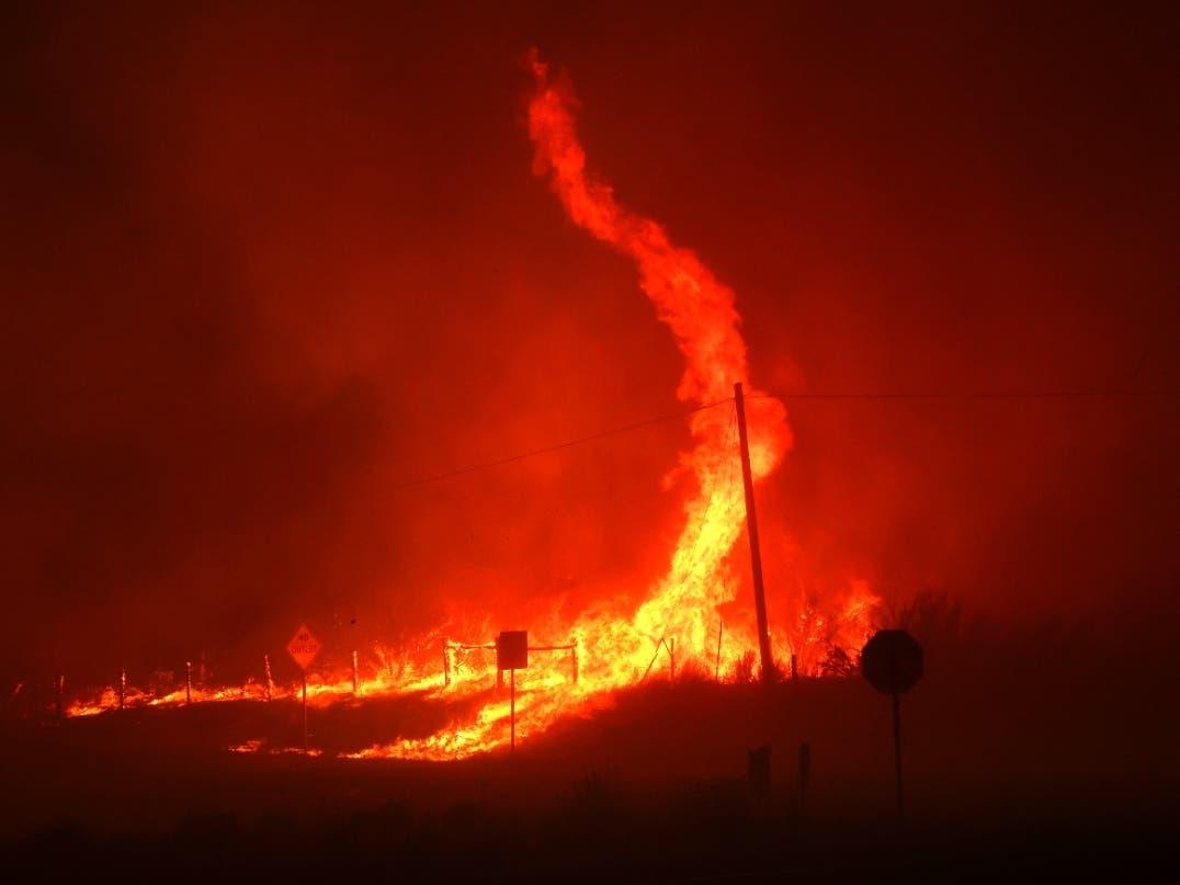
CALIFORNIA — Firefighting forces in California are stretched thin battling 14 major wildfires, and the U.S. Forest Service announced Friday that it will close nine national forests in the state during the week leading up to the Labor Day Holiday.
The closures begin on Sunday and last through Sept. 6 as extreme fire conditions slam Northern California.
The forests subject to closure include the following.
Find out what's happening in Los Angelesfor free with the latest updates from Patch.
- Klamath National Forest.
- Lake Tahoe Basin Management Unit.
- Lassen National Forest.
- Mendocino National Forest.
- Modoc National Forest.
- Plumas National Forest.
- Shasta-Trinity National Forest.
- Six Rivers National Forest.
- Tahoe National Forest.
“We do not take this decision lightly and understand how this impacts people who enjoy recreating on the National Forests,” Regional Forester Jennifer Eberlien said in a written statement. “These temporary closures are necessary to ensure public and firefighter safety, as well as reduce the potential for new fire starts.”
About 12,460 firefighters are already spread across the state battling monster fires, including the Dixie fire, which spans 1,060 square miles and has been burning since July 13. As of Friday, the Dixie fire was still just 35 percent contained and menaced 16,000 structures, Cal Fire reported.
Find out what's happening in Los Angelesfor free with the latest updates from Patch.
On Thursday alone, another 27 brush fires broke out in the state. Crews managed to contain them quickly in order to devote resources to the massive fires already burning across Nothern California.
To help Californians keep safe and keep tabs on where fires are burning, the National Alliance for Public Safety GIS Foundation created an interactive map showing all active fires.
The map showed recently contained fires and regions that have a red flag warning in place. The map does not show evacuation routes, but the foundation also maintains a spreadsheet with updated evacuation maps in areas that apply.
Cal Fire Currently Monitors 13 Fires Of Interest
Glen Fire: Yuba County, Northwest Of Dobbins
- 184 acres, 99 percent contained.
- 10 structures destroyed.
- All evacuations lifted.
Dixie Fire: Butte, Plumas, Lassen, Tehama And Shasta Counties
- 700,630 acres, 35 percent contained.
- Nearly 16,000 structures threatened.
- 1,208 structures destroyed (14th most destructive wildfire).
- Unified Command of Cal Fire, U.S. Forest Service, Bureau of Land Management and National Park Service.
Caldor Fire, El Dorado County, South Of Grizzly Flats
- 73,415 acres, 0 percent contained.
- Evacuation orders and warnings remain in place.
- Nearly 6,900 structures threatened.
- More than 100 structures destroyed.
- Emergency forest closure of all lands, roads, and trails within the El Dorado National Forest.
- Damage assessment underway.
French Fire, Kern County, Sequoia National Forest
- 4,272 acres, 5 percent contained.
- Evacuation orders in place.
McFarland Fire: Shasta, Trinity And Tehama Counties, Shasta-Trinity National Forest
- 115,996 acres, 52 percent contained.
- Evacuation orders and warnings remain in place.
Monument Fire: Trinity County, Five Miles West Of Big Bar, Shasta-Trinity National Forest
- 142,250 acres, 10 percent contained.
Federal Incidents
Antelope Fire: Siskiyou County, Five Miles South Of Tennant, Klamath National Forest
- 64,827 acres, 30 percent contained.
River Complex: Siskiyou County, Seven Miles West Of Callahan, Klamath National Forest
- 80,400 acres, 10 percent contained.
- Complex is comprised of 23 fires; 16 fires contained
McCash Fire: Siskiyou County, Ten Bear Mountain McCash Creek, Six Rivers National Forest
- 7,659 acres, 0 percent contained.
Walkers Fire: Tulare County, 16 miles Northeast Of Springville, Sequoia National Forest
- 2,482 acres, 15 percent contained.
Lava Fire: Siskiyou County, Northeast Of Weed, Shasta-Trinity National Forest
- 26,409 acres, 85 percent contained.
- Two structures damaged.
- 23 structures destroyed.
Beckwourth Complex: Lassen/Plumas Counties, Northeast Of Beckwourth, Plumas National Forest
- 105,670 acres, 98 percent contained.
- 23 structures damaged.
- 148 structures destroyed.
Tamarack Fire: Alpine County, South Of Gardnerville, Humboldt-Toiyabe National Forest
- 68,637 acres, 82 percent contained.
Extended Attack Incident
Bell Fire: Mendocino County, Five Miles East Of Leggett
- 50 acres, 100 percent contained.
Cache Fire: Lake County, Clearlake
- 75 acres, 40 percent contained.
Historic drought and recent heat waves tied to climate change have made wildfires more difficult to quell on the West Coast. Rising temperatures have made the American West much warmer and drier in the past 30 years and will continue to make weather more extreme and wildfires more frequent and destructive, scientists have said.
The explosive pace of new wildfires showed no sign of slowing.
"Today more than 12,460 firefighters continue to battle 14 large wildfires across the state.
Yesterday firefighters responded to 27 new wildfires, all of which were quickly contained," Cal Fire reported Thursday. "Since January 1, there have been 6,630 wildfires that have burned more than 1.4 million acres."
Weather conditions were expected to aid firefighters Friday, but wind gusts are expected to return on Saturday to drive the spread of flames.
While all red flag warnings for extreme fire weather have been lifted, firefighters continued to work against drought conditions, Cal Fire warned Friday. "West to southwest winds are projected to continue through the weekend and into next week. On Saturday, gusts up to 30-35 mph are expected in many areas, including the Greater Lake Tahoe area, Lassen, Eastern Plumas and Eastern Sierra Counties. After a brief break from dense smoke, smoke will likely return to areas of the Sierra crest and into far western Nevada starting tomorrow afternoon."
The Dixie fire is the Golden State's largest wildfire so far this year, burning 700,630 acres and destroying more than 1,200 structures and more than 600 homes.
Pacific Gas & Electric Co. equipment may have ignited the Dixie fire, according to a report released by the utility last month.
Last month, a repairman reportedly spotted what he suspected to be a blown fuse while he was responding to an outage in Feather River Canyon off Highway 70 in Oroville. Because of rough terrain and roadwork, the worker could not reach the pole for several hours, the utility said. By the time he reached the area, two or three blown fuses may have sparked a fire at the base of a healthy green tree leaning on the pole that held the conductor.
The combination of worsening drought, rising temperatures and arid fuels pointed to another devastating wildfire season, Gov. Gavin Newsom warned in May.
"You're already feeling the temperature shifts," he told reporters. "You already saw those red flag warnings, which are earlier in May than we've seen in many, many years because of the winds that are coming earlier. "
Californians last year were hard-pressed to find refuge between an intensifying coronavirus pandemic and a hellscape of wildfires that hampered air quality all over the state.
A historic 4,257,863 acres of California burned last year in the state's largest fire season in modern history. As fire season was already in full swing last year, more than 12,000 lightning strikes hammered the state, igniting massive fires. The state also experienced its first "gigafire" in 2020: a burn area that exceeded 1 million acres.
This year, the state is falling deeper into drought, which means that firefighters could find themselves facing fires in thousands of miles of dry brush, grass and trees across the state, all ripe for a wildfire season amplified by warming, dry temperatures and high winds.
READ MORE:
- 4 Key Things To Know About CA's 2021 Wildfire Season
- PG&E Says Its Equipment May Have Sparked NorCal Fire
Patch Editor Kat Schuster contributed to this report.
Get more local news delivered straight to your inbox. Sign up for free Patch newsletters and alerts.