Weather
12 Inches Of Snow Expected In RivCo Mountains Near Murrieta
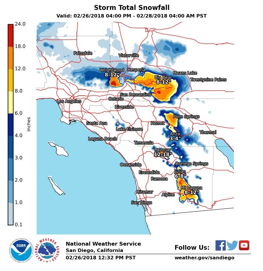
Bundle up, Riverside County! Area mountains may see up to 12 inches of snow!

RIVERSIDE COUNTY, CA — After several days of cold — yet dry — weather across the Inland Empire, an approaching cold front is expected to dump rain and snow in the region overnight Monday into Tuesday. Mountains in the Southland will get up to a foot of snow in this storm, according to the National Weather Service.
Described as "very cold" storm, the system is going to bring "widespread rain and snow," weather officials said on Monday afternoon.
"We expect our mountain community locations at 5,000 to 6,000 feet to see anywhere from six to 12 inches of snow," Meteorologist Alex Tardy said in the video briefing embedded above. "We'll even see some wet snowflakes all the way down to 2,000 feet on Tuesday."

As a result, commuters are being asked to prepare for hazardous driving conditions on Tuesday.
"Snowfall will make slippery road conditions and possibly impassable for a time at higher elevations," meteorologists said. "Blowing snow and fog will reduce visibility at times."
Some highlights of this storm are:
- Heavy snow is predicted around 4,000 feet, with about 6 to 12 inches expected
- 2 to 4 inches of snow are expected to fall above 2,500 feet
After this upcoming storm, wet and cool weather is expected to continue through the end of the work week, according to NWS forecasts.
Here's the National Weather Service forecast for Murrieta for the coming days:
Monday Afternoon
Rain likely after 4pm. Mostly sunny, with a high near 64. Southwest wind around 15 mph, with gusts as high as 20 mph. Chance of precipitation is 60%.
Monday Night
Rain. Low around 39. Southwest wind around 5 mph becoming northwest after midnight. Chance of precipitation is 100%.
Tuesday
Showers before 10am, then showers likely and possibly a thunderstorm between 10am and 4pm, then a slight chance of showers and thunderstorms after 4pm. High near 51. Light and variable wind becoming south 5 to 10 mph in the afternoon. Chance of precipitation is 80%.
Tuesday Night
A 20 percent chance of showers before 10pm. Patchy frost after 10pm. Otherwise, mostly cloudy, then gradually becoming mostly clear, with a low around 33. Calm wind.
Wednesday
Patchy frost before 10am. Otherwise, sunny, with a high near 58. Light south wind becoming southwest 5 to 10 mph in the morning. Winds could gust as high as 20 mph.
Wednesday Night
Partly cloudy, with a low around 39.
Thursday
Increasing clouds, with a high near 58.
Thursday Night
Rain likely. Mostly cloudy, with a low around 40.
Friday
Showers likely. Partly sunny, with a high near 56.
Friday Night
A chance of showers. Partly cloudy, with a low around 38.
— Image via Ey Mariya, Shutterstock.com