Politics & Government
Remember When Temecula, Murrieta And Wildomar Would Flood?
Efforts to prevent future flooding of Murrieta Creek are still alive.


SOUTHWEST RIVERSIDE COUNTY, CA — Flood control efforts along the Murrieta Creek channel that runs through Temecula, Murrieta and Wildomar received another round of funding, Rep. Ken Calvert (R-Corona) announced Thursday.
The $1.7 million in funding for the ongoing Murrieta Creek Flood Control Project is included in the U.S. Army Corps of Engineers Fiscal Year 2022 Work Plan that was released Wednesday and is part of this year's appropriations bill, which Calvert voted for and President Joe Biden signed off on.
The U.S. Army Corps of Engineers is expected to use the $1.7 million to further the construction of various flood control improvements, a multi-purpose trail, and riparian habitat along the Murrieta Creek channel.
Local officials are also eyeing a possible 50-acre regional sports park within the detention basin to include several soccer fields, baseball/softball fields, a tot playground, restrooms and picnic areas. It would be situated adjacent to Cherry Street and Jefferson Avenue, just west of the FedEx Shipping Center.
The Murrieta Creek Flood Control Project "will increase the channel capacity by excavating a wider and deeper channel section," according to environmental documents filed with the state. Rock and soil cement are proposed to protect the banks from erosion. The project will also include the establishment of a riparian corridor to provide higher quality native habitat for wildlife species, according to the environmental documents.
The project is intended to provide 100-year flood protection, according to the environmental documents.
"The Murrieta Creek project will provide significant flood control protection for the cities of Murrieta and Temecula when completed," Calvert said in a released statement. "The funding included in the Corps of Engineers’ work plan will pave the way for the construction of Phase 2B of project. I have been proud to work collaboratively with the County of Riverside, as well as the cities of Murrieta and Temecula to successfully advocate for this critical funding."
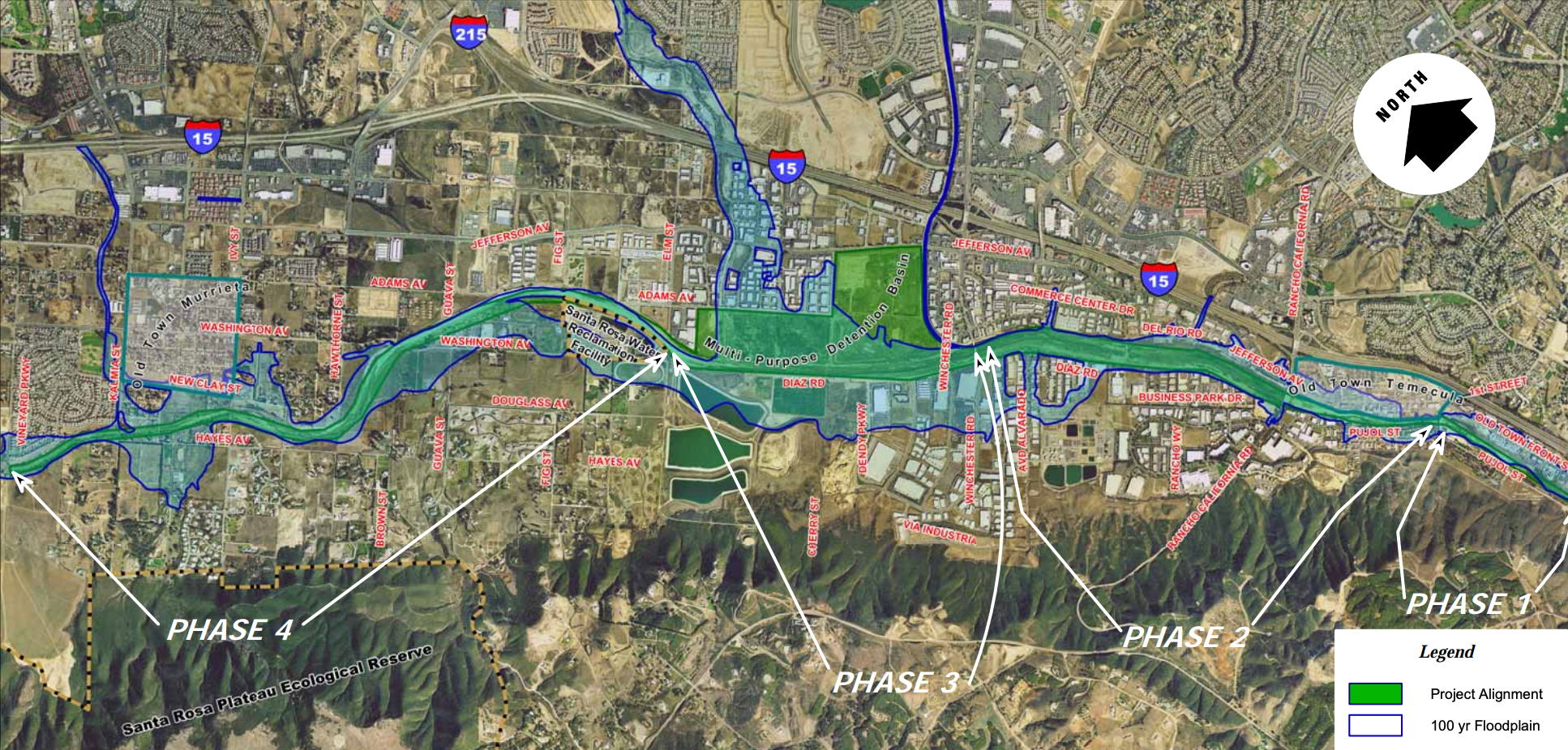
Phase 2B of the project includes construction work between Rancho California and Winchester roads.
Today the creek is dry and is known as a site for homeless encampments, but its waters have flooded Old Town Temecula, and the west sides of Murrieta and Wildomar. In January 1993, several days of heavy rains caused the creek to overflow, flooding surrounding homes and businesses, resulting in fatalities and roughly $100 million in damage.
Riverside County officials said the federal government was to blame for the death and destruction in Temecula and Murrieta caused by the flooding because local jurisdictions had not been allowed into the creek to remove growth and debris that blocked proper water flow.
The federal government has had oversight on the waterway. The Flood Control Act of 1936 along with the Water Resources Development Act of 1986 specify that "navigable waters" are a "proper activity" of the federal government in cooperation with states and local entities.
Murrieta Creek is approximately 13.5 miles long and drains an area of approximately 220 square miles, according to U.S. Army Corps of Engineers documents. It's part of the Santa Margarita River watershed that encompasses approximately 750 miles: Murrieta and Temecula Creeks converge downstream to form the Santa Margarita River that flows through San Diego County, passing through U.S. Marine Corps Base Camp Pendleton and into the Pacific Ocean, according to the documents.
Portions of the Murrieta Creek Flood Control channel were constructed by Riverside County in 1939, following damaging floods in 1938. For the next 25 years, no major modifications to the channel were made. By 1969, severe bank erosion and channel degradation had taken place, blocking water flow, so officials embarked on a restoration program. In the early 1970s, additional channel widening and deepening took place from approximately Rancho California Road to Winchester Road to protect newly developed homes and businesses, according to the U.S. Army Corps of Engineers documents.
Other channel restoration projects — from downstream of Old Town Temecula to as far upstream as Vineyard Parkway in Murrieta — took place in the years that followed, according to the documents.
Finally, in 2000, the Murrieta Creek Flood Control Project was initiated at an estimated cost of approximately $90 million. It's unclear what today's updated estimated cost is — and whether climate change and the ongoing drought may prompt future amendments to construction plans.