Weather
Snow, Rain Blanket Southland: Here Are The Storm Totals So Far
Rain, snow and hail, oh my! National Weather Service storm totals are in.

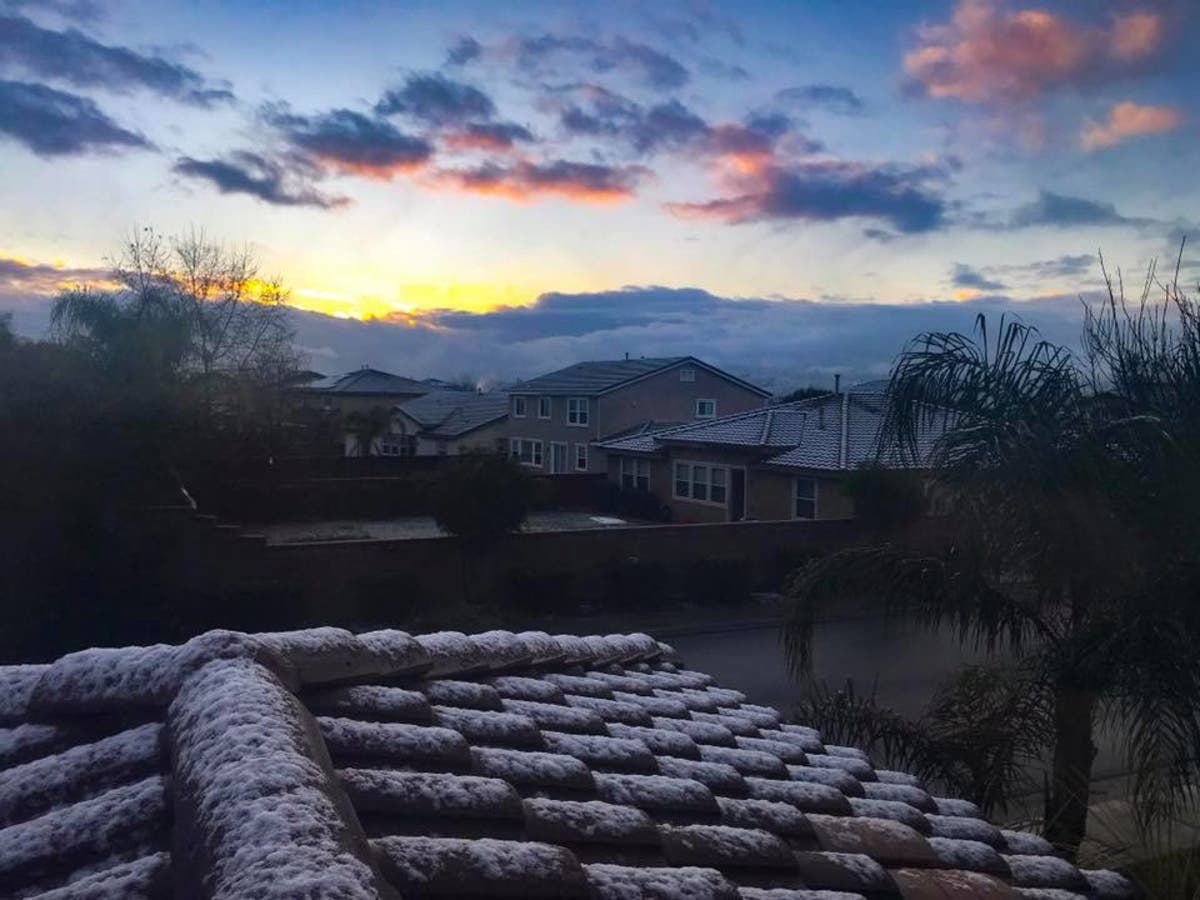
A cold storm system made its way across the Southland early Tuesday morning, dumping rain, hail and snow in the region. Snow levels dropped down to 2,000 feet, making for some hazardous road conditions for commuters — but some beautiful photo ops for those adventuring outside.
According to the National Weather Service, the most snow fell in Big Bear, with 8 inches of fresh powder blanketing the ski resort. Running Springs also received 8 inches, while Oak Glen got 6 inches and Idyllwild got 5. (Scroll down for full rain and snow totals).
Forecasters say the storm is still making its way across Southern California on Tuesday and there's a slight change of more rain and thunderstorms.
"Snow showers will continue in the mountains and adjacent foothills, along with cold conditions," the NWS said. "The storm will exit to the east tonight, with fair but cool weather Wednesday and Thursday. The next storm will move through southern California Friday and Saturday and will bring more rain with snow in the mountains, but a warmer atmosphere will preclude the really low snow levels. Fair weather will likely return early next week."
Share your local snow photos by sending them to renee.schiavone@patch.com.
If, like us, you were curious as to how much snow and rain fell in the region, we've got you covered. Here are the preliminary storm precipitation totals (for a 24-hour period) as of 9:01 a.m.:
| LOCATION | SNOW(In) | ELEVATION(Ft) |
| BIG BEAR RESORT | 8 | 7000 |
| RUNNING SPRINGS | 8 | 6200 |
| BLUE JAY | 7 | 5400 |
| GREEN VALLEY | 6 | 6800 |
| CRESTLINE | 6 | 4900 |
| WRIGHTWOOD | 6 | 5900 |
| FOREST FALLS | 6 | 6000 |
| OAK GLEN | 6 | 4900 |
| MT BALDY | 6 | 6400 |
| ANGELUS OAKS | 5 | 5800 |
| IDYLLWILD | 5 | 5200 |
| MT LAGUNA | 5 | 5200 |
| PINE HILLS JULIAN | 5 | 4200 |
| ARROWBEAR | 5 | 6200 |
| PALOMAR MOUNTAIN | 5 | 5200 |
| FERN VALLEY | 4 | 5000 |
| BIG BEAR YARD | 4 | 6800 |
| DESCANSO | 3 | 3500 |
| PINON HILL | 1 | 3500 |
| PHELON | 1 | 3500 |
| RANCHITA | 1 | 3200 |
| OAK HILLS | 0.5 | 3300 |
| ALPINE | TRACE | 2000 |
.TOP RAINFALL AMOUNTS FROM ALL ZONES
Information shows the station name, precipitation amount (in inches) and elevation (in feet).
1. OTAY MOUNTAIN RAWS 0.85 3283
2. HARBISON CANYON 0.82 1240
3. SKYLINE RANCH 0.81 562
4. BARONA 0.80 1280
5. FLINN SPRINGS 0.79 880
6. SD COUNTRY ESTATES 0.78 1660
7. MT. WOODSON 0.76 1720
8. BROWN FIELD 0.75 524
9. GRANITE HILLS 0.74 533
10.THOUSAND TRAILS 0.74 740
.SAN DIEGO COUNTY COASTAL AREAS
Information shows the station name, precipitation amount (in inches) and elevation (in feet).
BROWN FIELD 0.75 524
SAN YSIDRO 0.59 30
EL CAMINO DEL NORTE 0.58 50
CARLSBAD 0.57 305
SMUGGLERS GULCH 0.51 74
CHULA VISTA 0.47 120
CPEN LAKE ONEILL 0.47 109
TIJUANA ESTUARY 0.47 20
CARLSBAD EAST 0.46 610
DEL MAR 0.45 295
SAN ONOFRE 0.44 162
ENCINITAS 0.43 242
KEARNY MESA 0.43 455
FASHION VALLEY 0.42 20
SD CITY HEIGHTS 0.41 305
GOAT CANYON 0.40 110
SD LINDA VISTA 0.39 270
SD UNIVERSITY HEIGHTS 0.37 345
MONTGOMERY FIELD 0.36 423
OCEANSIDE 0.34 30
VISTA 0.31 440
SAN DIEGO SEA WORLD 0.30 15
CPEN FALLBROOK RAWS 0.30 876
CARLSBAD AIRPORT 0.30 357
SAN DIEGO INTL AIRPORT 0.29 42
LA JOLLA 0.28 275
.SAN DIEGO COUNTY VALLEYS
Information shows the station name, precipitation amount (in inches) and elevation (in feet).
STATION PRECIP(IN) ELEVATION(FT)
HARBISON CANYON 0.82 1240
SKYLINE RANCH 0.81 562
BARONA 0.80 1280
FLINN SPRINGS 0.79 880
SD COUNTRY ESTATES 0.78 1660
MT. WOODSON 0.76 1720
GRANITE HILLS 0.74 533
THOUSAND TRAILS 0.74 740
LOS COCHES CREEK 0.70 560
DULZURA SUMMIT 0.69 1512
GOOSE VALLEY RAWS 0.68 1530
ALPINE 0.67 1700
RANCHO BERNARDO MESONET 0.63 690
RANCHO BERNARDO 0.63 690
RINCON SPRINGS 0.62 970
RAMONA 0.62 1420
VALLEY CENTER 0.61 1295
VALLEY CENTER RAWS 0.60 1370
MIRAMAR LAKE 0.59 130
SANTEE NORTH 0.58 505
RAMONA AIRPORT 0.58 1400
LAKE WOHLFORD 0.58 1490
ESCONDIDO 0.58 640
LA MESA 0.56 530
COLE GRADE RD 0.56 750
SANTEE 0.55 300
LAKE MURRAY 0.55 530
LAKESIDE 0.54 625
ALPINE RAWS 0.54 2041
EL CAJON 0.52 493
DEER SPRINGS 0.51 1000
LOWER OAT FLATS 0.50 2239
POWAY 0.47 440
SCRIPPS RANCH EAST 0.43 930
SAN MIGUEL RAWS 0.42 425
COUSER CANYON 0.41 285
BONSALL CRS 0.40 185
RAINBOW CAMP 0.39 1553
RED MOUNTAIN 0.34 1600
FALLBROOK 0.33 675
.SAN DIEGO COUNTY MOUNTAINS
STATION PRECIP(IN) ELEVATION(FT)
Information shows the station name, precipitation amount (in inches) and elevation (in feet).
OTAY MOUNTAIN RAWS 0.85 3283
LA JOLLA AMAGO 0.70 2400
HENSHAW DAM 0.69 2750
VALLECITOS REPEATER 0.67 2945
MESA GRANDE 0.61 3204
LA JOLLA ERN TANKS 0.59 3000
DESCANSO RS 0.37 * 3650
SANTA YSABEL 0.34 2990
ECHO DELL 0.30 3060
WARNER SPRINGS 0.29 3040
DESCANSO RAWS 0.28 3480
CAMPO 1N 0.27 2610
PINE HILLS FS 0.23 * 3645
OAK GROVE RAWS 0.23 2770
PINE HILLS RAWS 0.15 * 3600
CAMERON RAWS 0.14 3443
PUERTA LA CRUZ 0.10 2970
RANCHITA 0.10 * 4008
PINE VALLEY 0.08 * 3730
TIERRA DEL SOL 0.04 * 4000
CAMPO ASOS 0.02 2609
.SAN DIEGO COUNTY DESERTS
Information shows the station name, precipitation amount (in inches) and elevation (in feet).
SAN FELIPE 0.04 2280
COYOTE CK 0.02 1189
.ORANGE COUNTY COASTAL AREAS
Information shows the station name, precipitation amount (in inches) and elevation (in feet).
OCEANVIEW 0.55 43
E GARDEN GVE/WNTRSBRG 0.51 120
SANTA ANA ENGINEERING 0.47 170
PICO RETARDING BASIN 0.44 760
BELL CANYON 0.44 700
BEE CANYON 0.43 755
YORBA LINDA 0.41 370
LAGUNA HILLS 0.40 400
SANTA ANA FIRE 0.40 112
YORBA PARK 0.40 305
ANAHEIM HILLS 0.39 1231
LAGUNA NIGUEL PARK 0.39 200
FULLERTON CSU 0.36 240
BREA OLINDA 0.35 750
YORBA RESERVOIR 0.35 300
ALAMEDA STORM CHANNEL 0.35 339
HUNTINGTON BEACH 0.35 20
UPPER ALISO CREEK 0.35 560
LAGUNA CYN REPEATER 0.32 530
SANTIAGO CREEK 0.32 120
PETERS CANYON WASH 0.32 40
LAGUNA BCH @ WOODLAND 0.32 47
JOHN WAYNE AIRPORT 0.31 50
EL MODENA-IRVINE 0.28 70
COSTA MESA 0.27 47
LAGUNA AUDUBON 0.27 314
LOWER OSO CREEK 0.27 220
FULLERTON AIRPORT 0.26 96
MILLER BASIN 0.25 220
CORONA DEL MAR 0.24 300
SAN JUAN GUARD 0.24 660
UPPER OSO CREEK 0.24 420
WESTMINSTER CHANNEL 0.23 40
SAN JUAN CAPISTRANO 0.23 75
SAN CLEMENTE PIER 0.21 25
BREA 2W 0.20 340
GARDEN GROVE 0.20 80
GILBERT RETARDING BSN 0.19 100
SAN DIEGO CK @ CAMPUS 0.19 20
SEGUNDA DESHECA 0.18 85
ANAHEIM BARBER CITY 0.16 5
SANTA ANA DELHI CHNL 0.16 24
MOULTON PEAK REPEATER 0.16 888
VILLA PARK DAM 0.07 560
LAKE FOREST 0.02 970
.SANTA ANA MOUNTAINS
Information shows the station name, precipitation amount (in inches) and elevation (in feet).
SANTIAGO CREEK 0.57 1210
MODJESKA CANYON 0.55 1260
UPPER SILVERADO CYN 0.44 2880
SANTA ROSA PLATEAU 0.41 1980
EL CARISO RAWS 0.38 2660
EL CARISO 0.32 2600
SIERRA PEAK 0.30 3040
FREMONT CANYON RAWS 0.26 1781
.SAN BERNARDINO COUNTY VALLEYS-THE INLAND EMPIRE
Information shows the station name, precipitation amount (in inches) and elevation (in feet).
DALEY SPUR 0.55 2680
SMALL CANYON DAM 0.55 1810
CUCAMONGA CANYON 0.51 1766
DAY CANYON 0.47 1880
HIGHLAND PLUNGE CREEK 0.47 1911
SAN ANTONIO HEIGHTS 0.44 2335
LARSON RANCH 0.44 2121
SAN SEVAINE SPRDG GRD 0.43 1938
GLEN HELEN REG PARK 0.43 2000
ELDER GULCH 0.43 2933
RIALTO AIRPORT 0.40 1418
CAL ST SAN BERNARDINO 0.40 1556
CUCAMONGA BASIN 0.39 1551
ONTARIO FS #4 0.39 1081
CHINO HILLS 0.39 988
ELDER CREEK 0.39 1649
HEMLOCK BURN 0.39 2280
CRAFTON RESERVOIR 0.39 2000
YUCAIPA REGIONAL 0.39 2620
LITTLE CHINO CK 0.36 646
WILSON CREEK 0.35 2235
ALTA LOMA 0.34 1940
GILBERT ST NR SBD 0.33 1120
ELY BASIN 0.31 832
LYTLE CREEK CANYON 0.31 3060
CHINO AIRPORT 0.29 650
SAN TIMOTEO LANDFILL 0.28 1766
RIALTO CHANNEL 0.27 1018
ONTARIO AIRPORT 0.24 922
RECHE CANYON 0.23 1021
SAN BERNARDINO CO YRD 0.20 1033
CORONA LUISENO 0.16 1395
.RIVERSIDE COUNTY VALLEYS-THE INLAND EMPIRE
Information shows the station name, precipitation amount (in inches) and elevation (in feet).
HEMET VALLE VISTA 0.59 2050
BEAUMONT 0.47 2624
NORCO 0.43 650
CRANSTON RAWS 0.41 1950
GILMAN HOT SPRINGS 0.40 1511
FRENCH VALLEY 0.38 1425
FRENCH VALLEY AIRPORT 0.36 909
PORTRERO CANYON 0.35 2220
TEMECULA 0.35 1180
SKINNER LAKE 0.35 1700
RIVERSIDE AIRPORT 0.34 847
BEAUMONT RAWS 0.33 2680
LAKE MATTHEWS RAWS 0.33 1522
RIVERSIDE SOUTH 0.32 875
HEMET/RYAN FIELD 0.28 1510
MURRIETA CK AT TENAJA 0.28 1100
WOODCREST DAM 0.27 861
CLARK RAWS 0.27 1718
RIV PRESIDENTIAL PARK 0.25 880
VAIL LAKE 0.25 1470
PIGEON PASS DAM 0.24 1700
MURRIETA 0.23 1250
PERRIS CDF 0.23 924
CABAZON RAWS 0.23 2155
RIVERSIDE - MARCH ARB 0.22 1535
RAILROAD CANYON DAM 0.20 1420
MORENO-CLARK 0.19 1810
.RIVERSIDE COUNTY MOUNTAINS
Information shows the station name, precipitation amount (in inches) and elevation (in feet).
BANNING BENCH 0.36 * 3619
SAGE RAWS 0.36 2560
GARNER VALLEY CENTRAL 0.09 * 4585
PINYON PINES RAWS 0.06 * 4060
.COACHELLA VALLEY
Information shows the station name, precipitation amount (in inches) and elevation (in feet).
WHITEWATER TROUT FARM 0.16 2200
MORONGO VALLEY 4SSW 0.08 2400
WINDY POINT 0.04 1060
.SAN BERNARDINO COUNTY MOUNTAINS
Information shows the station name, precipitation amount (in inches) and elevation (in feet).
DEER CREEK DAM 0.63 2917
LYTLE CREEK RAWS 0.57 2790
MT BALDY VILLAGE 0.49 * 4230
STRAWBERRY CREEK 0.39 2986
CITY CREEK RANGER STA 0.32 2647
MORMON ROCK RAWS 0.22 3300
WILDWOOD CANYON 0.16 2946
.APPLE AND LUCERNE VALLEYS
Information shows the station name, precipitation amount (in inches) and elevation (in feet).
MOJAVE FORKS DAM 0.18 2449
ANTELOPE CREEK WASH 0.14 3103
VICTORVILLE LANDFILL 0.14 2959
HESPERIA 0.13 * 3580
APPLE VALLEY 0.12 2762
ORO GRANDE 0.12 2798
GRANITE MOUNTAIN RAWS 0.12 * 4720
ADELANTO 0.11 2896
DESERT KNOLLS WASH 0.11 2808
HELENDALE 0.04 2428
LUCERNE VALLEY 0.02 3035
— Patch photo by Renee Schiavone